Characterising the Landscape: Topographic Survey
Fieldwork
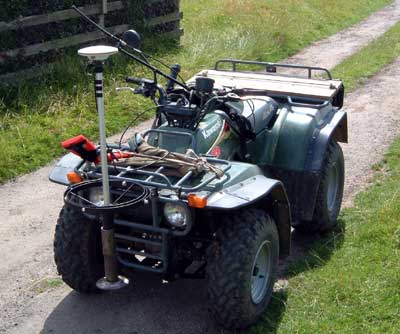
The topographic surveys were carried out using a Leica System 500 GPS, a Real-Time Kinematic satellite navigation system that allows continuous recording of data at high accuracy, usually to within one or two centimetres. This consists of a reference station that remains stationary at a known point, and a 'rover' which for the purposes of these surveys was mounted on either a quad bike (below) or Landrover driven at low speed over the terrain to be modelled.

The reference station gathers satellite data continuously and broadcasts corresponding correction data to the rover in order to maintain accuracy. The time or distance interval at which the rover records a point can be specified according to requirements. The vehicle mounted rover was driven in traverses across the field recording a point every 2.50 metres, providing the accuracy of that point was within 5 centimetres. This results in the collection of several thousand height readings for each site surveyed. Where variations in topography were obvious in the field, break lines were also recorded along the top and bottom of the slopes. The figure below illustrates the density of height readings for site 120, some 20,177 readings.

Data Processing
The information gathered was initially processed using Leica's SKI-Pro software to convert the data to the Ordnance Survey grid. These data were exported as a text file, and imported into an Access database containing the topographic information for all the sites surveyed using this method. The data used for modeling the topography were then filtered to exclude all points with an accuracy less than 2.5 centimetres, and exported as a CSV (comma separated variable) file for each site.
The topographic data were imported into G-Sys on a site by site basis, and interpolated using a Delauney tessellation to produce the contour plots included in the various site dossiers, and a DEM (digital elevation model) for each site. Subsequently the individual site triangulations were loaded into G-Sys and combined to produce landscape wide DEM. The availability of fields in which to undertake the topographic survey was dependant on crops and livestock etc., and it proved impossible to survey all the fields within the project area due to these constraints although the un-surveyed areas represent only a small part of the total area.
The topographic surveys were carried out by Guy Hopkinson of the Landscape Research Centre.
|
