|
Heslerton Parish Project: Morphology
Morphology and Landscape
The parish morphology both to the north and south of the River Derwent in the centre of the Vale shows a remarkable uniformity, and although those parishes to the north of the river are quite different to those to the south, incorporating a far larger upland component, in both cases they seem to reflect economically viable and roughly equal areas of the two different principal ecological resources from the lowland and upland areas. Only Yedingham, a monastic parish supported by revenues generated from the river crossing and lands situated beyond the parish, and perhaps from barge traffic on the River Derwent, does not conform to this pattern. Yedingham was the highest navigable point on the river during the nineteenth century, although little is known about the state and use of the river in earlier periods.

Fig. 1: Parish Morphology of Helserton and surrounding area
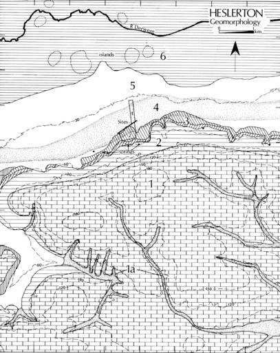
Although the choice of Heslerton as the focus for a long term landscape research project was reactive rather than pro-active, attention being focussed on the area following the discovery of the Anglian cemetery during mineral extraction, its central location along the southern side of the Vale of Pickering and an examination of the parish morphology (Fig. 1) and geomorphology (Fig. 2) across the Wolds-Vale interface indicated that the area could form a good representative sample for a much more extensive landscape, a landscape that spanned physical as well as ecological zones perfectly suited for human occupation.

Fig. 2: Parish Morphology of Helserton and surrounding area
(Click a Landscape Zone to link description)
The Heslerton Parish Project utilised a landscape transect (Fig. 3) to provide a theoretical and visual mechanism for encapsulating the evidence across the project research area. The transect provided a simple mechanism for presenting the combined evidence of geomorphology, topography and archaeology. By bringing together evidence form a 10km. wide swath extending to either side of the transect line a schematic view of the landscape could be constructed reflecting both land-use and, with respect to some activities, period as well.

Fig. 3: Heslerton parish landscape transect
After twenty years of research, the combination of soils, relief and water sources which form the foundations of the local ecology remain, not surprisingly, largely unchanged, with the exception of the peat deposits which continue to dry out at an alarming rate as a consequence of intensive drainage and water abstraction from the River Derwent. However, our interpretation has evolved reflecting the greatly enhanced resolution and density of the available data set. The six geomorphological zones characterised in 1980 still provide an effective framework with which to view the landscape; only in one zone, Zone 6, has a fundamental reinterpretation been required.
Next Page: Zones
|
