Multi-Spectral Imaging
LRC Project EH3841
Ground-based remote sensing
Ground-based remote sensing uses a variety of geophysical survey techniques to "see" beneath the surface of the soil, providing a map of the underlying archaeological, alluvial and geological features. The main techniques used at Heslerton have been magnetometry and earth resistance, with limited ground penetrating radar.
The desire for fast and effective methods to assist in the evaluation of archaeological potential, and the need for non-destructive methods of investigation, has led to the birth and growth of modern archaeological prospecting. The discipline was initially driven by adapting technologies from other disciplines, in particular geology and physics, although specialized machinery is now made specifically for archaeological purposes. The now wide availability of cheap electronic components and computers has given this process a further stimulus, enabling survey methods to be refined and allowing the time taken for surveys to be dramatically reduced, while the data can be processed and displayed in ways that had not previously been possible. Ground based remote sensing techniques are both cheaper and less labour intensive than the alternative option of excavation, and given the current position some years after the introduction of PPG16, the use of geophysical survey as a pre-excavation component of archaeological investigation seems set to continue to expand.
Magnetometry and resistivity are not the only two methods of ground-based archaeological prospecting, but they are the clear leaders in terms of achieving consistently useful results, and are both practical and fast. While there are a number of other types of instruments for measuring magnetic and electrical properties, this page will limit discussion to the two most widely used techniques. Although geophysical surveying has been used for many years, the prediction of the potential success or failure of any method to identify archaeological remains is largely dependent upon very localised conditions. Magnetic susceptibility can be used to pinpoint areas where magnetometers are most likely to be successful, although it is quite possible to detect features even where the susceptibility is low, providing other factors are present. Thus it is prudent to adopt a “try it and see” attitude with geophysical surveying, as quite spectacular results can be obtained even from sites which were expected to reveal very little. On the whole, resistivity meters are better at detecting buried walls and structures, while magnetometers are better at detecting “cut” features such as pits and ditches. Due to the nature of resistivity survey, it is slower than using the currently available fluxgate gradiometers, but new developments which use a quad bike to pull a wheeled resistivity system mean that this problem has now been overcome, and much larger resistance surveys can now be anticipated. Equally, a number of machine driven magnetometry devices are currently under development. However, due mainly to commercial constraints, most surveys carried out today use fluxgate gradiometers, as they are (relatively) cheap and can cover ground quickly.
A short history of geophysical prospecting in the area
A proton magnetometer survey was carried out over the Iron Age square barrow site at Arras on the Yorkshire Wolds in 1959 (Stead, 1979, 10). This was one of the earliest surveys of its type in Yorkshire, and a very creditable area of almost 3 hectares was covered. Unfortunately, in an area where 19 square barrows were subsequently shown by excavation to exist, only 2 were detected magnetically, and even these not completely (only 3 sides of each barrow ditch appeared as magnetic anomalies). Further work by Arnold Aspinall and Tony Pacitto in the 1970's and 80's demonstrated that other sites on the chalk Wolds, for example the East Heslerton long barrow, Paddock Hill, Thwing and areas around Rudston, responded well to magnetic survey (Arnold Aspinall pers comm).
In the sandy zone at the foot of the Wolds, initial trials by Arnold Aspinall over a known round barrow at the Cook’s Quarry excavations (Site 1) using both magnetometry and resistivity in 1980 were inconclusive; the sands and gravels in this zone were considered to be unresponsive to these techniques.
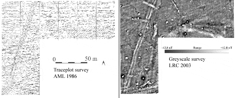
In April 1986, the English Heritage (Ancient Monuments Laboratory) team carried out a magnetometer and magnetic susceptibility survey at site 2, over an area suspected to be part of an Anglian settlement, as a precursor to excavation. The fluxgate gradiometer survey was carried out with an instrument which produced trace plots only and is documented in the AML report Series/No Geophysics G 3/86. The results clearly indicated the presence of a number of localised anomalies, some linear anomalies, as well as a number of less clearly defined linears. The area was resurveyed by the LRC team in 2003, and the greyscale plot is included as a comparison in the image below.

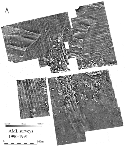
The 1986 survey demonstrated that magnetic techniques could work well on the areas away from the sands of the quarry zone, but did not reveal the full complexity of the underlying archaeology. Further work by the AML team, using a fluxgate gradiometer (model FM36) confirmed the effectiveness of the technique in this zone, with another 10 hectares of the Anglian settlement surveyed during 1990 and 1991, providing some stunning results (see below). This discovery led to the trial of using high resolution magnetic surveying over a stripped area.

|
