Excavations at Heslerton,
By DOMINIC POWLESLAND, with CHRISTINE HAUGHTON and JOHN HANSON
The Archaeological Journal,
1986, Volume 143, pages 53-173
This report describes the excavation of a 4 hectare multi-period site
situated in the parish of Heslerton, North Yorkshire, on the southern edge of
the Vale of
Occupation at the site began during the late Mesolithic with a flint
knapping area, which was also used during the Neolithic and early Bronze Age.
During the Late Neolithic a series of shallow gullies may represent the first
attempts to establish a field system, and domestic activity may be indicated by
two pairs of refuse pits. Other pits of this period demonstrate the presence of
an ill-defined avenue of very large post pits running across part of the site.
During the early Bronze Age two barrow cemeteries were present. The excavation
of
After the barrow cemeteries went out of use, woodland regenerated in the
area prior to the late Bronze and early Iron age, when the central part of the
site became the setting for extensive occupation dispersed along the line of a
major boundary which, once established, continued to function, though on a
lessening scale, throughout the Roman period when much of the site was turned
over to agriculture. During the early Anglo-Saxon period a cemetery was
established, focused upon
Note: This report has been prepared along the lines recommended by the Cunliffe Report (DOE 1975) and is divided into the printed report comprising of a description of all major contexts, their relationships and the artefactual and other evidence, with the principal periods of activity presented in eight chronological phases, labelled Periods 0 to 8; and the microfiche containing full specialist reports and supporting documentation. The complete archive from Site 1 is available for study by arrangement with Malton Museum.
INTRODUCTION
PROJECT STRATEGY
This report is the first of two covering rescue excavations carried out in the parish of Heslerton, in North Yorkshire, between 1977 and 1982. The Heslerton Parish Project was established in 1980 to provide an academic, framework against which to set the results of the excavations in an area of underestimated potential. The project area spans the interface between two distinct zones (Figure 1); in the south the scarp face of the Yorkshire Wolds rises to over 200m OD before gently sloping down into the Great Wold Valley whilst to the north the area is bounded by the River Derwent at the centre of the broad flat plain of the Vale of Pickering.
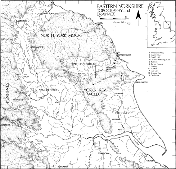
Figure 1 The Topography of Eastern Yorkshire
The position of eastern Yorkshire in the archaeology of the British Isles and northern Europe has long been established; the work of Greenwell (1877) and Mortimer (1905) has illustrated the wealth of its field monuments, but it is clear that the special place afforded eastern Yorkshire is largely based on the investigation of a single type of monument, the barrow, and also that the evidence is exclusively derived from the two upland areas in the region. On the chalk uplands, the Yorkshire Wolds included a large number of upstanding monuments, principally barrows and linear earthworks, which have frequently survived as modern boundaries. In the north of the region the North York Moors are similar, and it is easy to see why antiquarians and archaeologists have focused their attention on them. In contrast, the Vale of Pickering, separating these regions, has few upstanding monuments and in the past has been considered an area of very low potential, appearing on most distribution maps as a blank. Given that the distribution of barrows on the uplands indicates the presence of a large population in the area, the extent of the non-sepulchral database is minimal; what is perhaps more disturbing is that the work of Mortimer, Manby and others indicates that the Wolds, for the most part, become so badly denuded that only in exceptional conditions is there any likelihood of finding extensive domestic deposits that have survived erosion or destruction.
Excavations in the Vale of Pickering at Staxton and Sherburn by T. C. M. Brewster (1957, 1952) indicated that extensive aeolian deposits had preserved old land surfaces to an exceptional degree. The chance discovery in 1977 of Anglian metalwork, whilst stripping overburden at Cook's Sand Quarry, West Heslerton, led to a salvage excavation, undertaken by J. S. Dent (area 1HE, Figure 6b) followed by a small scale rescue excavation by the author in 1978 and 1979 (areas 1A, 1B, 1C, and 1D). The results of this work coupled with limited air photographic survey in the area indicated that the southern margins of the Vale not only contain very extensive archaeological deposits, but also that in places they were well preserved as a result of capping layers of aeolian sands derived from the sandy deposits in the centre of the Vale. The uniformity of the geology, topography and the nature and extent of the archaeological deposits indicated from the air suggested that the examination of the Heslerton area could provide a representative archaeological sample of an extensive landscape incorporating the whole of the southern edge of the Vale and the northern margins of the Wolds. The strategy was designed to transcend the restraints imposed by concentration on features or sites of any particular type or period, focusing instead on a landscape approach.
A parish transect was established running perpendicular to the geological, topographical, and environmental zones present which not only provided a means of presenting and isolating areas of particular potential but was also seen as a useful tool for the interpretation of the results of field-work (Figure 4).
The project, covering an 8 by 10 km area, includes the whole of Yedingham and Heslerton parishes together with parts of Sherburn to the east, Knapton to the west, East and West Lutton to the south, and Ebberston to the north, incorporating the parish boundaries. Since there is considerable uniformity in the parish morphology (Figure 2) both to the north and south of the Derwent, a detailed study of a single parish central to either group ought to provide a data base that is relevant to the group as a whole. The Vale has the potential to produce well-preserved and stratified sites, and it is possible that a detailed approach to part of the Vale will provide the necessary contexual data to enable the important body of evidence from the Wolds or the Moors to be set in a broader framework.
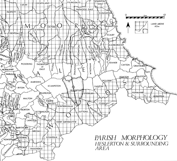
Figure 2 The Parish Morphology
TOPOGRAPHY AND GEOMORPHOLOGY
The project area covers a sample of the six distinct geomorphological zones, which can be identified at the interface of the two geographical regions (Figure 3).
Zone 1, the largest single zone, comprises the chalk downland of the Wolds top, defined to the north by the 150m contour and elsewhere by dry valleys containing extensive alluvial sands and gravels frequently capped by colluvium (Zone 1A).
Zone 2 incorporates the north facing scarp of the Wolds where the steep incline has restricted the formation of good soils, but where steep sided chalk knolls have provided an ideal setting for early settlement as in the case of the late Bronze/early Iron Age palisaded enclosures of Staple Howe and Devil's Hill (Brewster 1963; 1981).
Zone 3, spanning the basal red chalk and Speeton clay deposits between the 50m and 90m contours, incorporates the spring line and is the setting for the current settlements along the southern margins of the Vale.
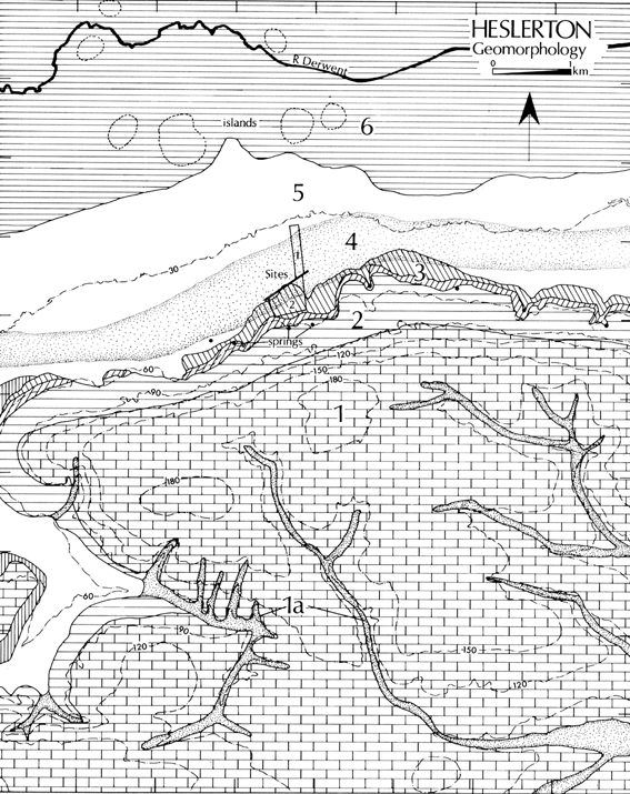
Figure 3 The Geomorphology of the Project Area
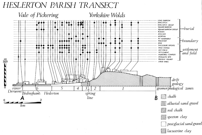
Figure 4 The Parish Transect
Zone 4 was defined as a result of the recent excavations and covers the extensive aeolian sand deposits which can be traced for over 10 km both to the east and the west of the project area. The deposition of the aeolian deposits over much of the zone has served to conceal and preserve areas of relict landscapes.
Zone 5, the dry vale, covers an area of postglacial sands and gravels bounded to the south by the overlying aeolian deposits and running into the lacustrine clays of the wet vale to the north.
Zone 6, at the base of the Vale bordering the River Derwent, comprises a large flat area of lacustrine clays frequently cut by relict, and now peat filled, water courses and including a number of slightly elevated gravel islands. Although Zone 6 would have supported a fenland environment during the later prehistoric period, successive drainage schemes have dried out the greater part of the area which, as in the other zones except Zone 3, now support intensive arable farming.
PAST WORK IN HESLERTON
Work in the parish began with Greenwell's identification of a long barrow at Heslerton Wold in 1868 which produced evidence of a Yorkshire Cremation long barrow (Greenwell 1877, 142-45) This may be a separate long barrow to that excavated in 1962 by F. and L. Vatcher which still survives as an earthwork (1965) and which was also typical of the Yorkshire series of cremation long barrows. Greenwell also examined three round barrows in the parish; Barrow VI produced a number of features typical of the Yorkshire cremation long barrow tradition, a facade bedding-trench and a ritual pit, and a quantity of Neolithic pottery. Barrows IV and V illustrated the high degree of organic preservation in the area, in the former a quantity of seeds was recovered and in the latter what was thought to be preserved leather (Greenwell 1877, 142). A prehistoric burial was recorded within the former quarry works in West Heslerton in 1968 by Brewster (pers. comm.) which was accompanied by a jet necklace normally associated with Food Vessels.
Work began on a palisaded settlement at Devil's Hill in 1966 (Brewster 1981) and was completed during 1981, when a number of structures, and the enclosing palisade with its entrances, were examined in detail (Brewster, forthcoming). The relationship of Devil's Hill in Zone 2, to the contemporary occupation examined in this paper is of great importance. In addition to these excavations, Brewster undertook a programme of field-walking within the parish in the 1950s which resulted in the recovery of finds including several polished axes, prehistoric and Romano-British pottery scatters, a number of Anglian beads and medieval pottery, together with structural traces (Brewster, pers. comm.).
THE EXCAVATIONS
LOCATION OF THE SITES
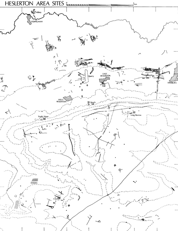
Figure 5 The Project Area Map
Sites 1 and 2 are located at the centre of the Parish Transect (PL. IA) extending across the whole of Zones 3 and 4 (Figure 4). Although the ground rises over 10 m towards the southern edge of Site 2 (NGR SE 91657625) the natural surface over Site 1 (NGR SE 91757670) dips away to the north at a uniform gradient, dropping only 5 m over 700 m and would have provided an ideal setting for early occupation with light, easily worked sandy soils. Access to the chalk uplands and the wetlands at the centre of the Vale would have been easy at most times and provided a wide range of ecological zones. The principal line of communication would have been to the east and west, along the Vale margin, providing access to the coast with its important flint deposits and to the Vale of York. To the north, routes would have been restricted, while to the south a number of dry valleys provide easy access to the Wolds, the plain of Holderness and the Humber. Excavation and air photography have indicated the presence of a series of relict stream channels draining into the vale from the spring line at the foot of the Wolds. These water courses, which appear to be regularly spaced at c. 200 m intervals, must have provided an important source of water, reducing the need for wells and the resulting requirement for nucleated settlements.
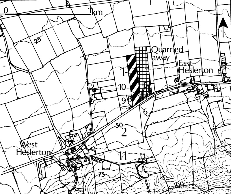
Figure 6a Location of Sites
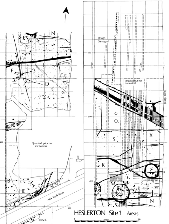
Figure 6b Site Plan showing Area codes
SOILS By Richard MacPhail (M1/76-97, M2/ 1-10)
The surface geology over both sites comprises sands and gravels derived as postglacial outwash from Forge Valley in the north-west corner of the Vale. From the southern edge of Site 2 chalk gravels give way to the mixed sand and gravel deposits characteristic of Site 1. The horizontally bedded sands at the southern edge of Site 1 are interspaced with chalk gravel which increases in density until at the northern limit of the site the quantity of sand is minimal. A complex sequence of erosion and deposition, starting at least as early as the late Neolithic, had left large parts of Site 1 capped with deposits of aeolian sands which in the central area (1D, 1K, 1L, 1M, 1N, 1P, and parts of 1R, 1S, 1T, and 1X) had preserved early ground surfaces from subsequent erosion and plough damage. Elsewhere on Site 1 plough damage had truncated the archaeological deposits to varying degrees in areas 1A and 1B in the south, and areas 1R, 1S, 1T, and 1X in the north.
METHODOLOGY (M1/72-74)
THE RESULTS
PERIOD 0: THE EARLIER MESOLITHIC (M1/75)
A series of relict stream channels emerges from the spring-line at the foot of the Wolds and is important both for site topography and water supply. Detailed examination of two of these provided evidence of erosion and depositional processes from the early Boreal phase onwards (Zylawyj, M2/11-17;M3/02)
PERIOD 1: THE LATER MESOLITHIC
THE EVIDENCE
No archaeological features can be assigned to this period, human activity being indicated solely by the lithic assemblage. This evidence is discussed in detail in two reports by Gillian Wilson presented originally on microfiche (M1/01-71), now linked as Flint Reports 1 and 2, from which the evidence below has been abstracted.
Three phases of flintworking can be isolated, all demonstrable through cores, tools, and debitage, the distribution being illustrated in Figure 7. The earliest, represented by microlithic tools, micro-cores and a number of blanks, represents about ten per cent of the total assemblage from Site 1. Given that the greater part of the assemblage is debitage rather than readily dateable tools the two criteria of breadth (< 10 mm), and method of detachment (indirect percussion), have been used to isolate what may be considered a minimum count of primary phase or late Mesolithic blanks.
The relative frequency of material attributable to this period is indicated in Table 2. Although the frequency of Mesolithic material remains fairly uniform when expressed purely as percentages of the total assemblage per excavated area, the density varies dramatically from one part of the site to another, ranging from 1 per 5.3 sq.m in area 1A to 1 per 4050 sq.m in areas 1T and 1X. The high densities present in areas 1A, 1B, 1E, and 1F towards the southern end of the site are of considerable importance. In these areas the density variation may to some extent be due to differential rates of recovery, but this alone cannot explain the differences.
The assemblages from areas 1B and 1F included cores, debitage, and identifiable microliths; those from 1A and 1C included a considerable quantity of debitage accompanied by microliths. In area 1B, where the proportion of tools and cores was the highest, a much higher density can be postulated since although the area investigated was quite large, c. 750 sq. m, only a small portion had not already been truncated by stripping. All the microlithic pieces were recovered from a strip covering a 15 by 15 m area against the western limit of excavation, where the sealing layers of blown sands appeared to be increasing in depth, producing a density of 1 per 5.7 sq. m, a figure which closely matches the high density in area 1A.
DISCUSSION
Besides a number of tools (including rods, crescents, edge-blunted points, backed blades, and an awl) and cores the material attributed to this period includes a large amount of debitage (278 pieces) which is viewed as a minimum rather than a maximum count. Thus it is clear that flint was worked on site during this period and that this activity was concentrated at the southern and western margins of the site in areas 1A, 1B, 1E, and 1F, the highest concentrations indicating a relationship between the flint knapping areas and the relict stream channel. It is unfortunate that the area between the high concentrations located in areas 1A and 1E was quarried away prior to the start of the excavation. Although the natural sands and chalk gravels of the site contain a large quantity of chert it is of very poor quality and all the raw materials of the lithic industries at both sites were imported.
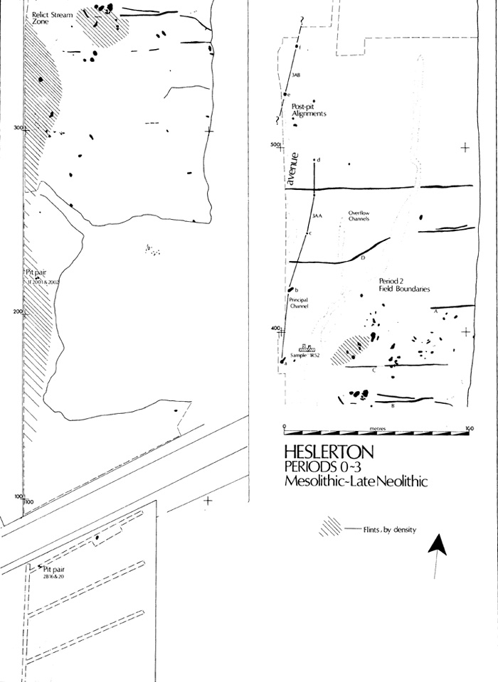
Figure 7 Plan of Periods 0-3 (Earlier Mesolithic, Later Mesolithic, Middle Neolithic and Later Neolithic)
PERIOD 2: MIDDLE-LATE NEOLITHIC
THE EVIDENCE (PL. IB)
The earliest man-made features are a series of ten ditches aligned broadly east-west. None produced artefacts but stratigraphic precedence was established to phase 3A pits, phase 4 burials and the mounds of barrows 1L and 1M. They are consistently of U-profile and less than 0.5 m deep. In two cases, in areas 1X and 1N, the ditches are paired, perhaps as quarries for hedge banks. Thin-section analysis of the fills (MacPhail M2/01-10) suggests that the ditches had been cut through a brown earth indicative of agricultural activity.
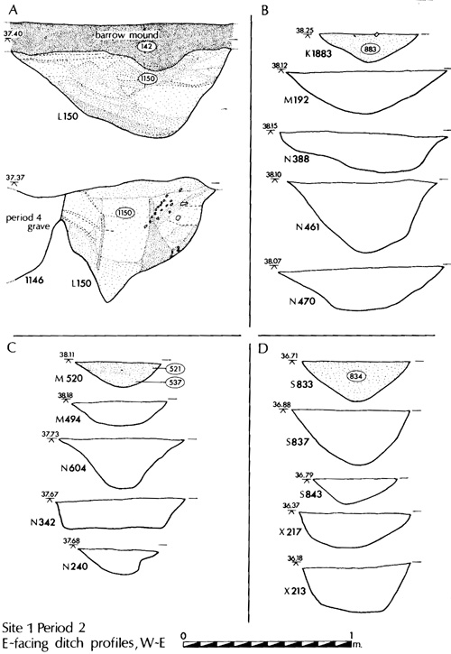
Figure 8 Period 2 ditch profiles
DISCUSSION
The total lack of artefacts from any of the segments examined reduces the degree to which these features may be interpreted; however the uniformity of profiles, scale, fills, and alignment suggests that the whole group is both contemporaneous and part of a system of land division or fields. If they are to be interpreted as early field boundaries then the lack of any elements running north-south must be explained. Given the presence of the active stream course on the western margin of the examined area and a second, still active, to the east an acceptable system may be reconstructed in which the stream channels form the principal north-south boundaries. This arrangement would provide a series of 'fields' covering a 30m by 200m area at maximum.
PERIOD 3: THE LATE NEOLITHIC
THE EVIDENCE
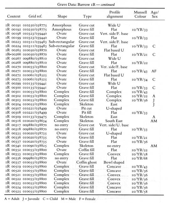
Three groups of Pits (3A-3C) are attributed to this phase by morphology or assigned function. They share a distinctive very dark fill (Munsell 10/YR/21-32), otherwise matched only in buried soil horizons and Period 4 barrow mounds and graves.
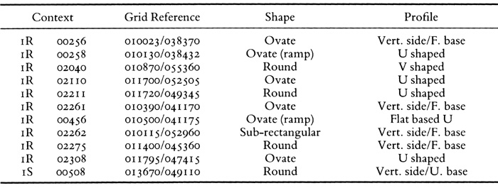
GROUP 3A (Figure 9, PL. IIA)
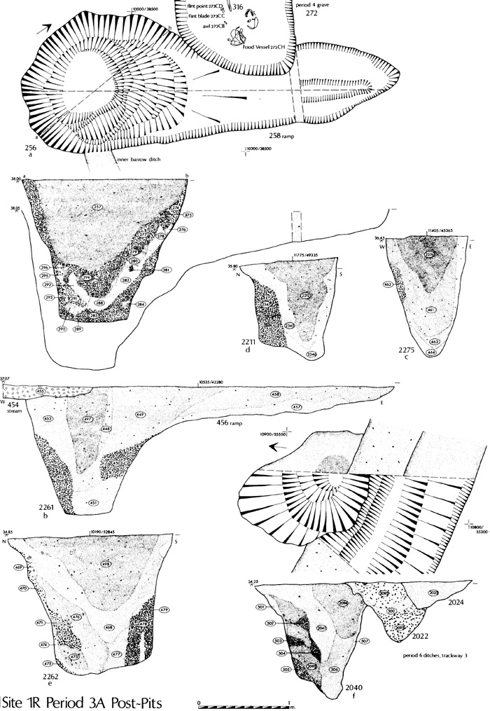
Figure 9 Period 3A pits: Sections and Plans
Eight large pits have been identified. All apparently had held massive posts and they appeared to form two irregular but parallel north-south alignments traced over some 175 m. The largest example (1R256) was sealed by Barrow 1R and was 1.6 m in diameter, 1.6 m deep with a ramp from the NE 2m long; a post diameter of c.0.6 m could be inferred. Its neighbour (1R261) was of comparable size and again ramped with a clear post-pipe c. 0.4 m in diameter. The remaining pits were smaller but could still have held substantial posts.
GROUP 3B
This comprises over 40 widely-dispersed pits, grouped by fill and morphology. Most were ovate with near-vertical sides, a sloping base, and a uniform infill. Two were sealed by a Period 4 barrow mound (1M235, 1M237) and another cut by a barrow ditch (1L1153); several preceded Period 5 features (1E1519, 1C2426, 1K1859).
GROUP 3C (Figure 10)
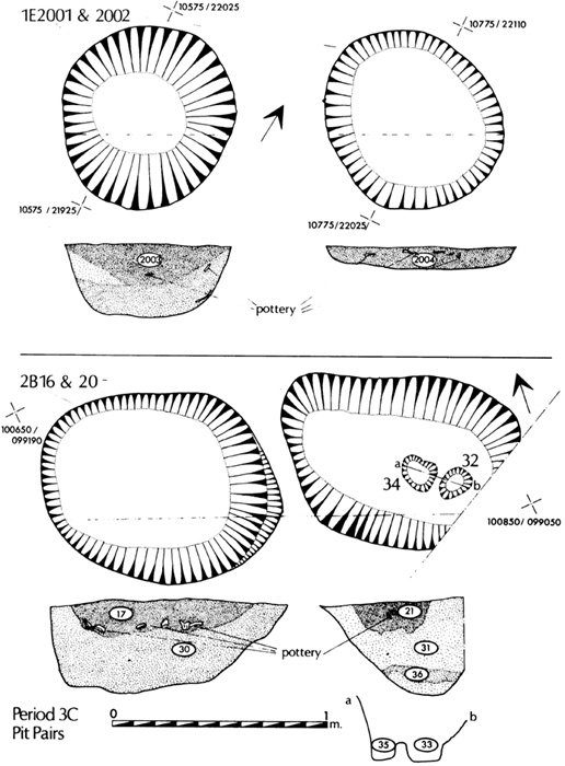
Figure 10 Period 3C Pit Pairs
Two pairs of pits produced quantities of later Neolithic pottery and other material. The first (1E2001 and 2002) were excavated by J. Dent in 1977-78 and lay 2m apart. Both were circular, 0.8 m in diameter, and flat-based, depths 0.34m and 0.11m with fills of dark sand. Contemporaneity can be presumed from the pottery represented (Figures 11 and 12). The second pair (2B16 and 20) were m and 0. 0.97 m in diameter and 0.4 m deep with a black sandy fill incorporating carbonized material including burnt bone and hazelnut shells. The pottery (Figures 12 and 13) and a fragment of jet cylinder bead were concentrated in the upper fills.
OTHER EVIDENCE
Apart from scattered material, especially in the southern part of Site 1 and beside the relict stream channel in areas 1E and 1F, features likely to be of this period were sealed by Barrows 1M and 1R. Beneath the south-west side of 1M was a row of six post-holes aligned NE-SW, and at the east side was another group defining a possible ovate structure, 5 m by 3.5 m in area. A much-damaged scatter of post-holes lay beneath the north side of 1R.
The total flint assemblage, including scattered material, comprises over 4000 pieces and ranges from imported raw materials to finished products, representing earlier Neolithic to early Bronze Age traditions.
D1SCUSSION
Three basic phases in the 1ithic material have been identified, one of which, the Mesolithic, has been assigned to period 1 (seeM1/25, M1/66). The remainder, about 90 per cent of the overall assemblage, dates from the Neolithic and early Bronze Age. The presence of serrated blades, leaf-shaped arrowheads, and a single laurel leaf indicate earlier Neolithic activity, particularly in area 1F, a suggestion which gains some support from the examination of the debitage. Following the scheme suggested by Pitts and others (M1/32) in which the blade industries are assigned to early, and broad flake industries to late Neolithic phases, Wilson has demonstrated a marked concentration of blades in areas 1F and 1B. The lack of any early Neolithic material in the ceramic assemblage however indicates that at this period the foci of activity must lie elsewhere; the small number of tools, and in particular the arrowheads, could result from casual loss. Although this distinction between the early blade and later flake industries may be tenable with reference to material in Wessex, there is no reason to believe that this distinction should be so readily accepted in the North. During the late Neolithic concentrations of ceramic material, particularly Peterborough type wares, both within the Period 3C pits and elsewhere indicate some degree of domestic activity. Apart from the pit groups the highest densities of late Neolithic material were in areas 1F (39 sherds) and 1A (17 sherds), and even though this suggests some degree of activity it must still have been limited, the distributions perhaps being peripheral to more extensive activity to the south and west of Site 1.
Regardless of whether this distinction between early and late Neolithic lithic material can be accepted in the light of the limited ceramic assemblage, which is predominantly later Neolithic, that the site was a centre for flint knapping can be readily accepted. The flint assemblage, amounting to more than 4000 pieces, includes the complete spectrum of material from imported raw materials through to finished products. This flint knapping industry, concentrated in the same areas as that related to period 1 cannot be closely related to the feature groups discussed above.
The phase 3A pits are the most distinctive of the pit groups and appear to be post pits which may be interpreted as the component parts of an irregular avenue crossing the site from the south-south-west in a north-north-easterly direction, comprising two alignments, 3AA and 3AB (Figure 7). Three of the pits certainly contained massive posts and there is no reason to believe that the other pits in the series did not perform the same function. The limits of the site preclude more detailed interpretation at present. but it is possible that further evidence may come to light in future extensions of the quarry, particularly to the west, which would allow for a more detailed assessment.
The phase 3B pits are perhaps the most difficult to interpret; they were readily definable during excavation as a coherent group, based upon morphological grounds, and it is assumed that this must relate to their function. The well-defined and frequently vertical sides indicate that they must be man made but their function must remain unknown.
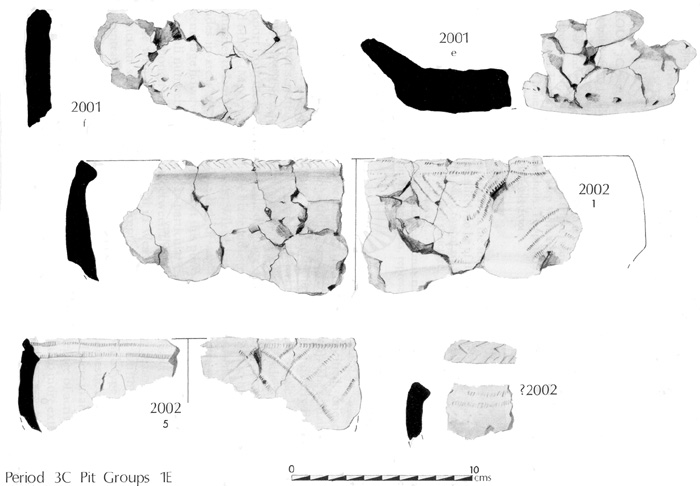
Figure 11 Pottery (Period 3C) from Area 1E
The phase 3C pits belong to a class widely recognized both in eastern Yorkshire (Manby 1974) and from elsewhere (Bradley 1982). The pairing of these pits is an important feature which has been identified at a number of the Grooved Ware sites on the Wolds collated by Manby (1974). Both contained extensive assemblages which cross-relate in each pair, indicating contemporaneity of the backfilling. In both cases the material would seem to derive from a domestic context and its concentration in the upper fills suggests that it was deposited there as a secondary function of the pits.
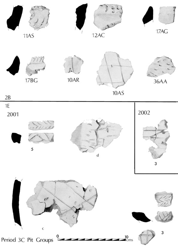
Figure 12 Pottery (Period 3C) from Areas 1E/2B
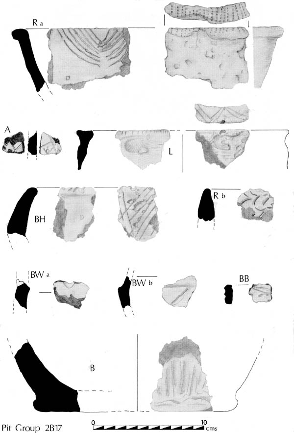
Figure 13 Pottery (Period 3C) from Area 2B
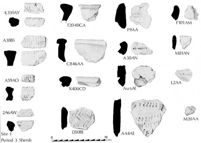
Figure 14 Other Period 3 pottery
THE LATE NEOLITHIC POTTERY by T. G. Manby (M2/23-43)
Towthorpe Style
Three pieces appear to be from vessels of the Middle Neolithic Towthorpe style: 1C846 AA, 1K400 CD, 2B U/S. The first two may be pieces of the same vessel.
Peterborough Ware
The main spread of sherds at Heslerton Site 1 consists of Peterborough Ware with some Beaker sherds of small size. The principal assemblages comprise the sherd groups from two pits, 1E2001 and 2002. There are no complete vessels, but at least three, probably six vessels, are determinable from pit 1E2001 and five vessels from pit 1E2002. The fragments show little evidence of weathering, the broken edges are uneroded. The general characteristics allow attribution to the Fengate style and the prevailing vessel form can be reconstructed as tall jars with deep collared rims, the body running downwards at a steep angle to a narrow flattish base. Decoration shows a preference for fingernail impressions to form herringbone patterns on the internal rim bevels. The same technique applied to the collars produced standing and pendant arc patterns. Arcs were also produced in cord maggot, used for lines on rims and collars. A sharp point was employed on some vessels to produce the herringbone on the internal bevel; it was used for the criss-cross lattice on the bodies. Some vessels display pits on the bodies immediately below the collar. A further technique observed is finger-tip rustication to furrow the collar.
All these decorative methods and motifs can be paralleled at the Fengate type site (Leeds 1922, B10-12, 15, 17 & 21) at Peterborough. Further Fengate style collared vessels come from Salmonby, Lincolnshire (unpublished; Lincoln Museum), Mount Pleasant, Derbyshire (Garton and Beswick 1983, 19-20) and the East Yorkshire sites of Driffield and Acklam Barrow 211 (Manby 1957a). Closely related in shapes and decoration to West Heslerton are the conical vessels from Thirlings, northern Northumberland, where one pit produced a carbon 14 date of (HAR1451) 2130 + 130 bc (Miket 1976, 119, Figure 7. 10-12). The few C14 dates associated with Fengate style pottery has been noted to extend over half a millennium and pre-dating (BM-75) 1540 + 156 bc at Windmill Hill causewayed enclosure (Garton and Beswick 1983, 20).
Extending the collared profiles and the preferred fingernail-incised motifs of Fengate-Heslerton assemblages are the wider range of vessel forms and decorative motifs provided at the Wold site of Carnaby Top Site 19 (Manby 1975, 41-44, Figures 13-14). Here are elaborately moulded hammershaped rims with internal ridges, and there is a preference for incised herringbone patterns. T-rimmed vessels with incised decoration are present amongst the Fengate style assemblages at Driffield (Manby 1957, Figure 2.5), and Fengate (Leeds 1922, Figures 11 and 12). The weak neck and rounded shoulder of these vessels bear little resemblance to the well-modelled forms at Carnaby Top and their decoration is of a simple casual character. This element is also present at Heslerton.
The Late Neolithic date for the Fengate style is emphasized by the occurrence of scattered Beaker sherds. The development of this style of Peterborough Ware over its very wide geographical distribution, from Kent to Wiltshire and northwards to Northumberland, is not at present fully understood. It emerged as one of the Peterborough styles of Burgess's Mount Pleasant Period c. 2750 B. c. to 2000 B. C. which was also the period spanned by Steps 1 to 4 of Lanting and van der Waals British Beaker sequence (Burgess 1980, 37-68). It is likely that a Fengate assemblage with a wide range of vessel forms including hammer-shaped rims such as Carnaby Top Site 19 is earlier than the Heslerton assemblage. The Carnaby Top material has a great proportion of elements derived from earlier Ebbsfleet, Mortlake, and earliest Rudston styles (Manby 1975, 54-5 5). The development of the Peterborough styles, Mortlake, Rudston, and Fengate, is not a linear series, but overlapping and parallel developments chronologically and regionally, that culminated in the Food Vessel and Collared Urn traditions of the early Bronze Age.
The Carbon 14 Dates
A number of radiocarbon dates are awaited relating to the complete activity sequence at the site. Discussion of these dates will appear in a later report. Those dates which are available are referred to under the relevant sections of the text.
PERIOD 4: THE EARLY BRONZE AGE
THE EVIDENCE
Period 4 represents one of the three principal phases of activity at the site and is represented primarily by two round barrow cemeteries. Barrow Cemetery 1 was located at the centre of Site 1 in areas 1L, 1M, and 1R, while Barrow Cemetery 2 was situated 300 m to the south in areas 1A and 1HE, extending beyond the limits of Site 1 onto Site 2 to the south. The full limits of neither cemetery were examined; in the case of Barrow cemetery 1 the presence of a barrow to the east of Site 1 may be inferred from the discovery of a burial accompanied by a jet necklace of Food Vessel type during quarry operations in 1967, while further barrows associated with this cemetery are indicated by crop marks to survive in the adjacent field (Site 10). Further barrows associated with Barrow cemetery 2, which survived to a lesser extent on account of plough damage, may be inferred on Site 2 by the excavation of the Food-Vessel burial 2C40. The level of structural preservation was outstanding in the case of Barrow Cemetery 1 however, particularly in the case of Barrow 1L.
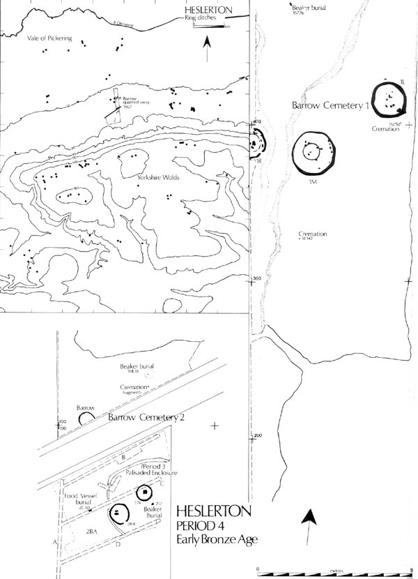
Figure 15 Eastern Yorkshire : Location of Barrows
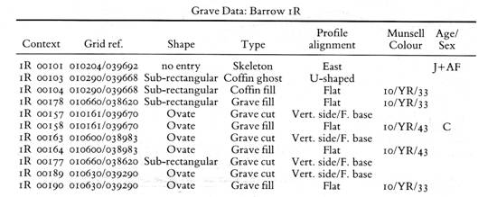
BARROW CEMETERY 1
If the burial accompanied by a jet necklace and located during quarrying in 1967 was indeed interred in a barrow, as is suspected, this (see Figure 15 for location) cemetery comprised at least five barrows. Two, 1L and 1M, were entirely within the threatened area. A third 1R, extended beyond the threatened area and thus only half was excavated. The fourth lay to the east while the fifth is indicated as a crop mark in the adjacent field to the West (Site 10). Three flat burials and two cremations located beyond the limits of any barrow demonstrate that burial practice was not restricted to ground enclosed by the barrow ditches. The evidence for each of the three barrows examined is discussed individually below.
Barrow 1L (Figure 16, Pls. IIB, IIIA)
This, the best preserved of the barrows, was entirely sealed by a capping layer of blown sand; thus the mound survived intact cut only by three graves and by a small number of very shallow plough marks, although the ditch had in places been cut by period 6 ditches. The monument was defined by a 1.5-2.5m wide, sub-circular ditch flattened on the southern side, measuring 22m in diameter and enclosing an area of c. 380 sq.m. The mound, which survived to a height of c. 3m, had partially slumped across the filled ditch.
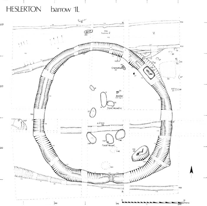
Figure 16 Barrow 1L Plan
The Mound (Section: Figure 74)
The mound, which was almost flat on the top, with a slight depression on the southern side, was composed of a homogeneous dark brown/black sand (Munsell range 10/YR/21 to 10/YR/32) which was virtually stone-free.
The examination of the deposits at the base of the blown sand around the perimeter of the barrow indicated that at the time the old land surface was scaled a turf deposit was not present. Dr MacPhail, in his report on the soils (M2/08), has suggested that the Period 2 ditch 1l150, sealed by the barrow mound, had been part of an agricultural landscape and that much of the barrow mound material must derive from A-horizon material. The lack of stone in the mound matrix may imply that the soil was derived from an abandoned agricultural and heavily worm turned soil, in which case part at least of the mound matrix may derive from the ground surface around the perimeter of the barrow. An increase in the density of stone at the base of the mound was identified with the interface of the mound and the old ground surface, and it may be that this concentration resulted from worm action in the mound redistributing the stone element that had been derived from the cutting of the ditch. Dr MacPhail has argued that prior to the construction of the mound the old ground surface was already denuded, perhaps through wind erosion, as one might expect after the abandonment of agricultural activity.
The Ditch
The barrow ditch had a regular broad V-shaped profile which was uniform except on the southern side, where there may initially have been a causeway. The depth ranged between 0.8m and 0.2m. Apart from limited cleaning in association with the backfilling of grave 1L1110, the ditch had not been cleaned or recut. The fills could generally be broken down into three layers: a primary silt composed of mixed sandy-silt and gravels; secondary silting comprising a mixed silty-sand combined with aeolian sands; and finally a stabilization layer of aeolian sand combined with loamy sand and barrow mound material. The fills in segment 1L1123 followed the same basic pattern as elsewhere except in the lower 0.3m, where redeposited mound material combined with evidence of cleaning give a different picture. The ditch profile had been widened on the outer edge by a shallow scoop which, on excavation, gave the impression of a squared-off corner to the ditch. This change in profile and the more complex sequence of ditch fillings may be attributed to a cleaning up operation associated with the insertion of the burial in grave 1L1110 0.5m to the north-west. This burial must have been inserted soon after the barrow mound was thrown up, certainly within six months; part at least of the soil derived from digging the grave pit had been thrown out across the ditch to the south-cast such that when the grave was backfilled, cleaning against the outer edge of the ditch broadened the profile which extended 0.65 m into a shallow scoop beyond the edge of the ditch proper.
The Burials
Nine burials were located within the area covered by the barrow; a further three were discovered in the immediate vicinity. Two examples were cremations, the remainder inhumations, two being accompanied by Food Vessels. The well-preserved nature of the barrow mound meant that it was possible to isolate the relative sequence of the burials with a high degree of certainty. The level of bone preservation in the majority of the Period 4 burials was very low, only surviving to any great extent where burials had penetrated the chalk gravel layers in the natural.
Primary Burials
Five graves were isolated in a primary position: four inhumations, 1L1146, 1L1147, 1L1149, and 1L55 lay within the central area, whilst the fifth, a cremation, 1L59, was located near the northern perimeter of the monument.
1L1146 (Figure 17), which cut the Period 2 ditch 1L150, was an ovate cut with vertical sides and a flat base. The generally homogeneous sandy matrix filling the grave included a patch of redeposited natural chalk gravel against the southern side, which led to the preservation of sonic fragments of adult long bones, probably male.
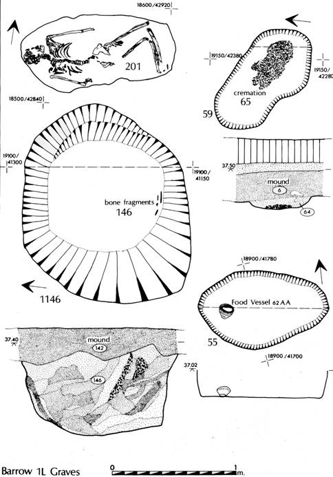
Figure 17. Barrow 1L: Primary Burials.
1L1147 (Figure 20), a sub-rectangular and shallow cut, contained no surviving bone traces but did contain an upright Food Vessel (1L147 AA, Figure 18) located against the south-west corner of the cut.
1L1149 (Figure 20) again cut the Period 2 ditch 1L150 and was sealed by the mound. It contained no artefacts but did contain fragments of long bones and staining indicating a crouched or flexed burial of indeterminate age and sex lying on the left side with the head to the north-west.
1LS5 (Figure 17) was the smallest of the grave cuts and, in the absence of any surviving bone or staining, was presumed to have contained an inhumation of a child. That the feature had been a grave was indicated by the presence of a small Food Vessel (1LS6AA,Figure 19) lying on its side at the western end of the cut.
1L59 (Figure 17) appeared to be the latest of the primary graves and contained the cremated remains of a young adult 1L65, which lay in a shallow scoop in the old ground surface. The mass of clean cremated bone was very well defined and appeared to have been contained. One metre to the west of the cremation an extensive deposit of charcoal, 1L17, lay on the old ground surface. This deposit, derived from some sizeable timbers, may be related to the cremation. The C14 date of this material provides a terminus post quem for the construction of the mound: (HAR-6690) 3840 + 40 b. p. (1890 bc).
Most of an S4 Beaker, 1L20 AA (Figure 19), was also found in a primary position, lying on the old ground surface beneath the northern side of the mound. The vessel had been smashed in antiquity and did not appear to relate to any burial.
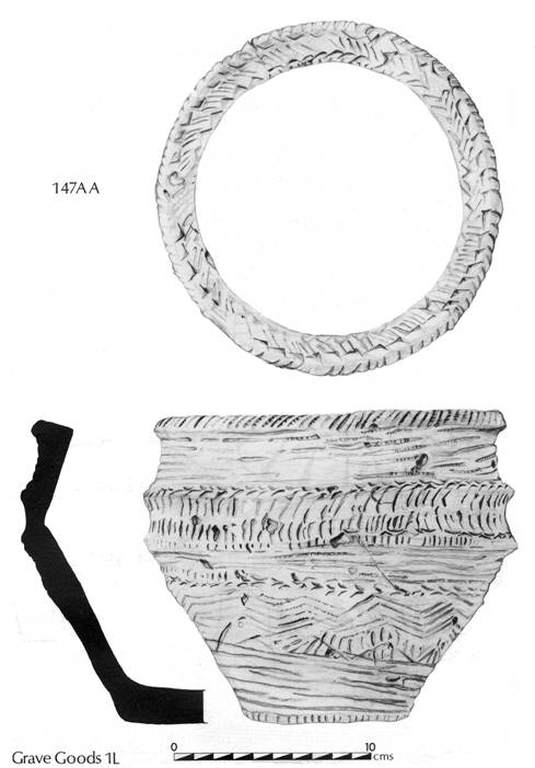
Figure 18. Barrow
1L: Pots (Food Vessel).
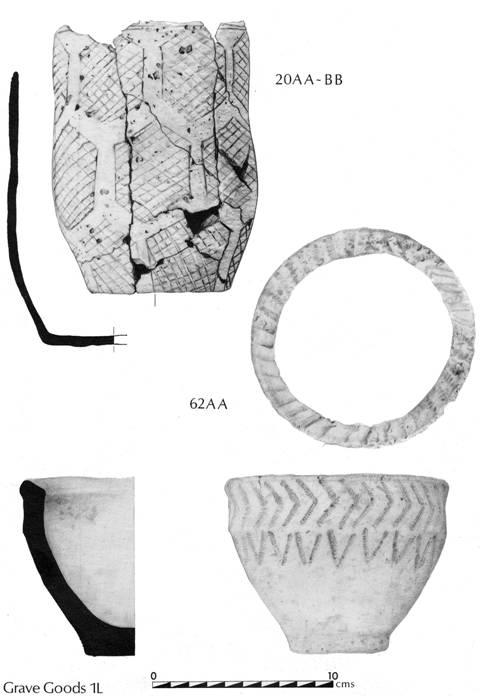
Figure 19.
Barrow 1L: Pots (Food Vessel and Beaker).
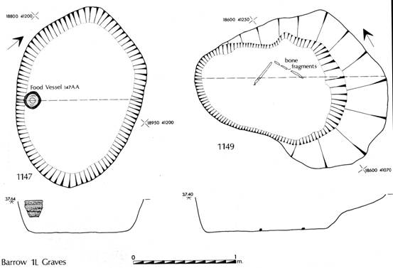
Figure 20.
Barrow 1L: Grave Plans (1147, 1149).
Secondary Burials
1L57 (Figure 21) was located nearest to the centre of the monument and may possibly have been a primary cut. The mound matrix and the grave fill were practically indistinguishable and although this feature could not be distinguished in plan on the mound surface, there was a slight indication in section of an associated cut through the mound. The grave contained no artefacts but did contain the poorly preserved long bones and tooth-caps of a young adult of indeterminate sex in a crouched position on the right side, facing cast with the head to the south.
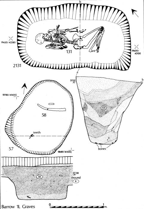
Figure 21. Barrow 1L: Grave Plans (57, 2131).
1L12 (M3/01) The secondary nature of this cut was much more obvious than in 1L57 above on account of the presence of quantities of aeolian material in its upper fill. The mixing of aeolian sand with the fill may indicate that it post-dated the construction of the mound by a considerable time; it contained no artefacts and only the slightest suggestion of a body stain, which could not be adequately defined.
1L1110 (Figs. 22 and 23), the most important of the secondary cuts, was located adjacent to the ditch in the south-east quadrant of the barrow. Its relationship to the ditch has been discussed above. The cut was by far the largest and contained the well-preserved bones of an adult male aged between 25 and 30 years. The body, which was flexed, lay on its back with the head to the south-west with the hands possibly clasped to the right of the cranium. The burial was unaccompanied. The C14 date for this burial will provide a terminus ante quem for the construction of the mound.
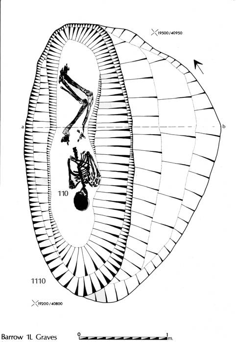
Figure 22.
Barrow 1L: Grave Plan (110).
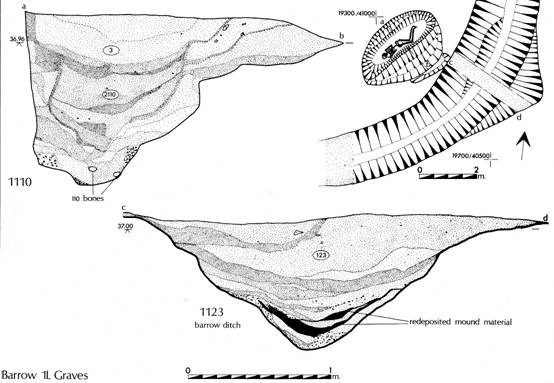
Figure 23. Barrow 1L: Grave 110 Location Plan; ditch section.
Tertiary Burials
One grave, 1L2131, may be considered to be represent a tertiary burial. Three other burials, 1L201, 1L83, and 1N750, cannot be securely linked with the phases of grave activity since they lay beyond the limits of the monument.
1L2131 (Figure 21) was a deep rectangular grave cut containing the well preserved skeleton of an adult male aged 25-30 years old, laid on the left side facing east with the head to the north-west. The legs were tightly contracted, the upper body extended and supine. This grave had been cut through the barrow ditch which by this time had almost completely filled in; the C14 date for the skeleton thus provides a terminus ante queen for the stabilization of the ditch.
1L201 (Figure 17), the prone burial of an adolescent female, lay three metres beyond the northern limit of the barrow ditch. Its relationship to the barrow had been destroyed by the Period 6 trackway which sealed it and had removed almost all evidence of the grave cut itself. The burial, which was aligned east-west with the head to the west, was unaccompanied.
1L83 was a shallow cut, at first thought to be a rubbish pit. It contained, however, a number of fragments of human bone including part of the shaft of an adult right tibia. The feature was almost certainly a grave but had been greatly disturbed by the northern boundary ditch of the Period 6 trackway which cut across the northern edge of this barrow.
Associated Burial Area
1N750, a cremation located eight metres to the south of the barrow but presumably related to it. The deposit, discovered in a baulk after completion of excavation of the area, was badly disturbed by animals; no associated artefacts were recovered. Insufficient bone was available for analysis.
The Human Bones by Jean Dawes (M2/18-19).
Barrow 1M (Figure 24, PL. IIIB)
This, the largest of the barrows examined, was located in the centre of the excavated area 65m to the south-west of barrow 1L; it was excavated in its entirety. Immediately to the west of this monument the relict stream channel separated it from barrow 1R 35m to the north-west. A small ring gully enclosed an area 10m in diameter at the centre of the monument, perhaps representing a primary phase; the main barrow ditch enclosed an area 25 m in diameter, its centre offset from that of the inner ring gully.
The Mound (Section: Figure75)
The mound was partially denuded, in particular on the western side where it appeared to have been eroded by stream activity. As with the other barrows in this group the mound matrix was heavily oxidized, individual turves could not be identified, and it was virtually impossible to isolate the interface between the mound and the old ground surface. The presence of a large fragment of a Food Vessel (1M3 6AA, Figure 27) on the mound surface in the centre may indicate that the mound itself had contained one burial at least, but that it had been destroyed by subsequent erosion.
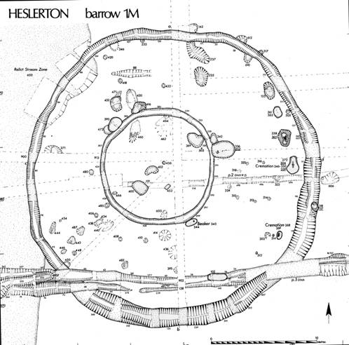
Figure 24. Barrow 1M: Plan.
If the ditches served as quarries for the mound material then the monument could never have stood to any great height, unless large quantities of mound make-up were brought in from the surrounding area. Taking the volume of the ditch at its largest point no more than 40 cubic metres of material would have been produced; this volume of soil, even allowing for the higher volume of loose as opposed to packed soil, would create a mound no more than 0.2 m in height if uniformly spread over the area enclosed by the outer ditch. On the inner edge of the outer ditch the black matrix was only c. 50mm thick, increasing in depth towards the centre of the enclosed area to a maximum of 0.2m, suggesting that the mound may have been largely confined to the central part of the monument. An examination of the mound in section (Figure 75) where it had been cut by the later ditch 1M60 revealed that at this point subsequent erosion through agricultural and other agencies had been restricted possibly by the presence of a hedge bank and an associated headland. The evidence from this section, when compared with adjacent areas, suggests that for the most part subsequent erosion and damage from agriculture was superficial.
The Ditches
The inner ring gully varied in breadth from 0.4m on the western side to 0.75m at its widest point; the sides were almost vertical and the depth nowhere greater than 0.25m. The fill, a stone free black sandy matrix, was uniform on all sides; a lack of any weathering layers indicating that the gully had not been exposed to the elements for any great time before it was filled. No rapid silts had formed in the base and the edges remained very well defined. Such a feature might well be considered to be structural, but there was no evidence to suggest that it had ever performed any such function. At a number of points the inner gully had been cut by later grave pits.
The outer ditch varied in breadth from 0.75 m on the north-western side, adjacent to the stream channel, to just under 2 m on the southern and eastern sides; the depth likewise varied from 0.5m to 0.9 m. On the western side the ditch had been rapidly filled soon after it was cut, probably as a consequence of flooding from the stream channel. On the eastern side the sections showed limited rapid setting followed by gradual filling with aeolian material as was observed in barrow 1L to the east. The ditch contained very few artefacts but was cut by a single grave, 1M118, which was inserted through the partially filled ditch on the eastern side. In contrast to barrow 1L there was no evidence of mound slip in the upper fills of the ditch.
The Graves
Given the large area defined by the outer ditch the number of grave cuts was very small. The level of bone preservation was very low, few graves being deep enough to cut into the alkaline chalk gravels which occurred at a depth of about 0.5m below the surface of the natural subsoil. In a number of cases, where no bone or artefacts were recovered, there can be no certainty that features were graves and not Period 3 Pits.
No single well-defined grave could be isolated within the central area defined by the primary ring gully; only one feature, 1M400, produced any bone, and only minute fragments. In contrast to barrow 1L the relative sequence of the grave cuts was difficult to determine, and it is assumed that the central ring gully defined the primary phase of the monument, a suggestion supported by the fact that this feature was cut by one certain and two possible graves.
Primary Burials
1M400 (Figure 25) was a shallow sub-rectangular cut, 0.18m deep and 1.32m long, which had cut through a Period 2 ditch/gully 1M915. The fill, a black sandy matrix, contained fragments of the shafts of two long bones, probably human and from a child. There were no accompanying artefacts nor sufficient bone or a body stain to indicate the position or alignment of the body. A very small quantity of burnt bone may also have been human but the quantity was insufficient to make any determination.
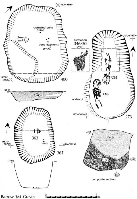
Figure 25. Barrow 1M: Graves 361, 400, 273
Two further cuts in the central area may also
have contained burials, 1M402, a shallow but irregular cut in the centre and
1M369 located adjacent to the ring gully on the north-eastern side. Neither
produced bone or artefacts which could be used to confirm their function as
graves. A third and much deeper cut, 1M460, was discounted as a grave on
account of its profile which compared well with the Period 3B pits.
Secondary Burials
The space between the inner and outer ditches contained a number of well-defined grave cuts containing inhumations and cremations, in once case, 1M273, in the same grave.
1M269 (Figure 26), a very small but deep ovate pit located in the south-east quadrant, had vertical uneroded sides and contained the cremation of a child or juvenile aged 8-12 years at death. The burial was unaccompanied.
1M344 (Fig 26) was located adjacent and parallel to, but not cutting, the outer edge of the inner ring gully in the south-east quadrant of the monument. The sub-rectangular cut, which was only 0.20 m deep, did not contain any human remains, but must have been a grave since it contained a Beaker (1M345 AA, Figure 27) standing almost upright in the centre of the eastern half.
1M273 (PL. IVA, Figure 25), located on the eastern perimeter of the enclosed area, contained three burials: in a primary position, skeleton 1M359 was of a small child aged 2-3 and probably female; the body was extended with the head to the south. This burial was sealed by a small quantity of chalk gravel, which may represent natural collapse of the grave walls, upon which lay the cremated remains of a female (samples 1M346-50) aged 25-30. This burial was in turn sealed by a thin layer of redeposited natural gravel upon which lay a second extended inhumation, skeleton 1M304, again that of a child laid out with the head to the south. The skeleton was probably that of a female, aged between 2.5-6 years. The shape of the grave both in plan and section, coupled with the layering demonstrable in the burials and the scaling deposits, indicate that the grave lay open between the insertion of the three burials, but that the time span between the insertion of the first and last burial must have been very short. An edge retouched knife (1M273) was recovered from the fill.
1M336 (Figure 28) was largest of all the grave cuts in this barrow, and must clearly be secondary to the inner ring gully through which it had been cut on its eastern side. The broad, shallow, egg-shaped pit was aligned east-west and contained the much decayed remains of an adult male skeleton laid out in a flexed position with the head to the east. This burial was accompanied by a crude edge-retouched flint knife (1M336 AA) placed just to the west of the feet.
1M338 (PL. IVB, Figure 26) was situated just inside the outer ditch 1m to the north of 1M273. The grave pit contained a tightly contracted skeleton of a child, probably female, aged 7-8. The long bones were disarticulated as a consequence of the tightly contracted position of the body. The body was accompanied by a perforated cow astragalus (1M365 AA, Figure 27), perhaps a toggle or a mace-head. Two fragments of cremated bone contained in the grave filling may be residual and indicate that this grave post-dates the nearby grave 1M273.
1M361 (Figure 25) This small grave pit, located to the north of 1M338 and just inside the outer ditch on the eastern side of the barrow, contained the fragmentary remains of the skeleton 1M363, an infant aged under I5 months. The burial, which was apparently flexed with the head to the south, was unaccompanied.
1M102, located on the southern side of the monument, was almost certainly a grave pit, given its sub-rectangular shape and size. Unfortunately all trace of any burial that it may have contained was subsequently removed during the cutting of the Period 5 ditch 1M902.
Four other features (1M52I, 1M370, 1M432, and 1M416) may also have been grave pits on the basis of their shape and size; unfortunately no bone or grave goods were recovered which could confirm this interpretation.
Just to the south-west of the barrow some human bone fragments were recovered during removal of the blown sands. No associated grave cut was located.
The Human Bones by Jean Dawes (M2/19-20)
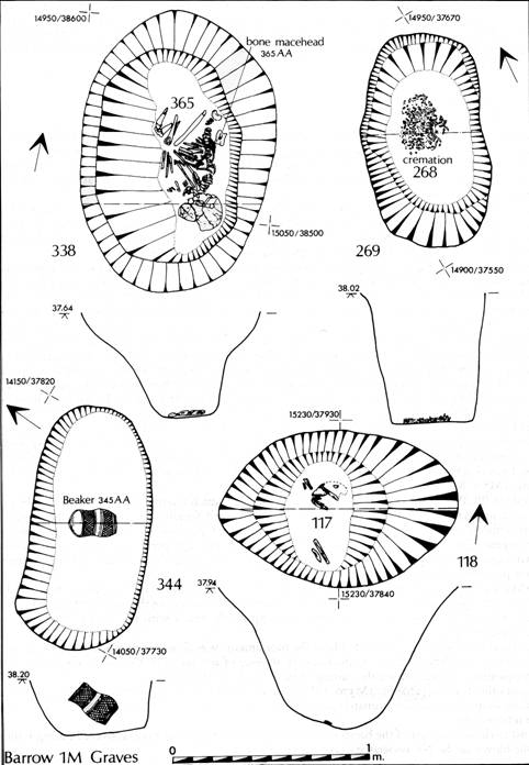
Figure 26.
Barrow 1M: Graves 338, 344, 118.
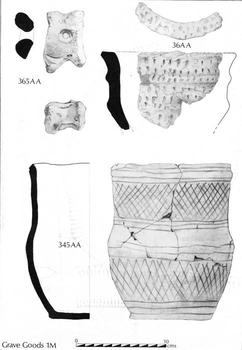
Figure 27.
Barrow 1M: Grave Goods 365, 36, 345.
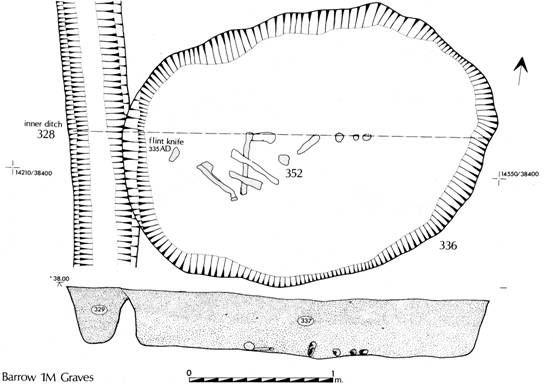
Figure 28.
Barrow 1M: Grave Plan 336.
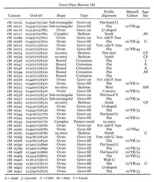
Barrow 1R (PL. VA, Figure 29)
This barrow, located on a slight platform in a bend on the western bank of the stream channel which separates it from barrow 1M 35m to the south-cast, extended beyond the limits of excavation to the west. It contained the highest density of burials in any of the barrows examined, the majority of which were accompanied. As with barrow 1M the central area was defined by a shallow ring gully, the outer ditch being much more substantial. Both the inner ring gully and the outer ditch were interrupted at a number of points. On the basis of the part examined the barrow appears to have covered an area up to 18m in diameter. Like the western side of barrow 1M, the mound seemed to have been partially eroded as a result of stream activity, the degree of preservation being generally lower than in barrow 1L. It is difficult to be certain as to the extent of this erosion since outside the central area, in which the surviving mound material was removed by hand, the area was stripped using a box scraper which removed part at least of the mound matrix.
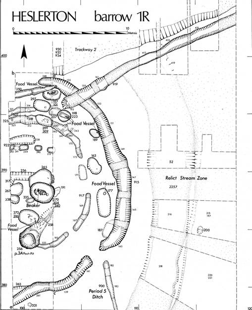
Figure 29. Barrow 1R: Plan
The Mound (Section: Figure 75)
Little mound material survived and it was not possible to make any clear distinction between mound material and relict soils preserved as an old ground surface. A number of medieval or later post-holes, and two gullies which cut across the centre following an east-west alignment, indicated the presence of a late field boundary which also cut across the mound of barrow 1M and area 1N to the east. The grave cuts were quickly identified after removal of the first few spits of mound material in the central area, whilst in between the inner and outer ditches grave cuts could be isolated after the first cleaning of the area. A fragment of human bone was recovered from the mound matrix, 1R240.
The Ditches
In contrast to that in barrow 1M the inner ditch or gully, which enclosed an area measuring 11m in diameter, had a maximum depth of 0.4m, maximum breadth of 0.55m and ill-defined and weathered edges, particularly on the eastern and south-eastern sides; it was interrupted at four points in the area examined. Although it cut through the Period 3A post pit 1R256 on its southern side it could not be traced in the metre wide gap between this feature and the western limit of excavation. To the north, where it was matched by a second similar feature, the gully was both deeper and better defined but its scale indicated that it may have been no more than a marking-out ditch.
The outer ditch, which was interrupted both to the north and to the south-east, had a maximum breadth of 1.25m and a depth of up to 0.7m. On the southern side, where the ditch ran out of the site to the west, it was broad and shallow (0.55m). Although a shallow scoop ran in a westerly direction, as one might expect if the barrow were round, the main ditch alignment turned to follow a more southerly direction for reasons which could not be explained from evidence within the excavated area. A slightly inturned entrance on the south-east side of the monument left a 1m wide gap in the outer ditch, matched by a similar gap in the inner ring gully, which left a narrow causeway giving access to the centre of the enclosed area. To the north, the outer ditch stopped 2m short of the western limit of excavation and did not resume within the excavated area. The primary silts which filled the ditch to a depth of 0.25m contained no artefacts, above this a homogeneous stabilization layer contained a high proportion of aeolian material from which a small number of sherds and worked flints were recovered. On the northern side the ditch was cut by a ditch terminal relating to a Period 6 trackway which passed the northern edge of this barrow and barrow 1L to the east. A second apparently related ditch continued to define the line of the trackway running out of the area to the west, leaving a small entrance c. 2m wide.
The Graves
This barrow produced the largest assemblage of grave goods but bone preservation was still poor. The area as originally stripped did not include the central part of the monument. After the discovery of bone in a shallow scoop, 1R191, against the western limit of the excavation, the area was extended to include the central portion.
The grave sequence can in part be determined from the relationships between some of the grave pits. It is assumed, as in 1M, that the primary phase of the monument is represented by the shallow inner ring gully. A feature of this barrow not matched in the other examples was the widespread distribution, in the grave fills, of disarticulated bones additional to the principal interments, indicating the presence of a number of additional burials. There were no cremations present in the part examined. Not only was the frequency of grave goods higher here than in the other barrows of this group, but there was also a greater variety; three graves contained copper alloy objects.
Primary Burials
1R270 (PL. VB, Figs. 30, 31)
In contrast to the other barrows in this cemetery, this monument contained a single major primary grave in the centre. The sub-rectangular grave pit, located in the southern half of the central area, was the largest of the graves examined, measuring 2.15m long, 1.8m across and 0.84m deep. It had clearly been filled and then subsequently reopened prior to the construction of the mound, and contained one complete articulated and two partial disarticulated skeletons. The greater part of a mature adult male skeleton, 1R340, lay in the base of the grave; the bones had been carefully stacked at the western end of the pit. This burial had been disturbed when a second insertion, 1R304, had been laid in the base of the grave; the lack of small bones in the stack suggests that by the time of this disturbance the body had mostly or completely decayed, the larger bones being collected together having been exposed during the reopening of the grave pit. There was no indication that the primary burial had been accompanied by any grave goods. The later interment, that of a 12-14 year old of indeterminate sex, was laid out in a crouched position on its left side with the head to the east, a Beaker (1R302 AC, Figure 32) placed in the angle between the upper and lower legs. A thin and broken layer of charcoal above this burial indicated the presence of at least two very thin planks which appeared to have been laid immediately on top of the body but no further trace of a possible coffin was seen. The principal fill, 1R271, contained a number of further bone fragments: three vertebrae which appeared to have been articulated at the time of deposition, parts of the long bones, cranium, left clavicle, and right hand of an adult woman aged about 30 at death, distributed randomly within the fill. Immediately sealing the burial 1R304, further fragments of human bone were found mixed in the fill 1R302. This grave was entirely scaled by the mound.
1R265 (Figs. 30 and 31)
This shallow flat based grave pit, which cut both the barrow mound and the primary grave 1R270, contained some tiny fragments of bone and a mandible with teeth indicating an age at death of between 10 and 17 years. The bone fragments were insufficient for sexing the body, which was accompanied by a flint flake (1R266 AF) and a tiny fragment of a copper alloy pin (1R266 AD).
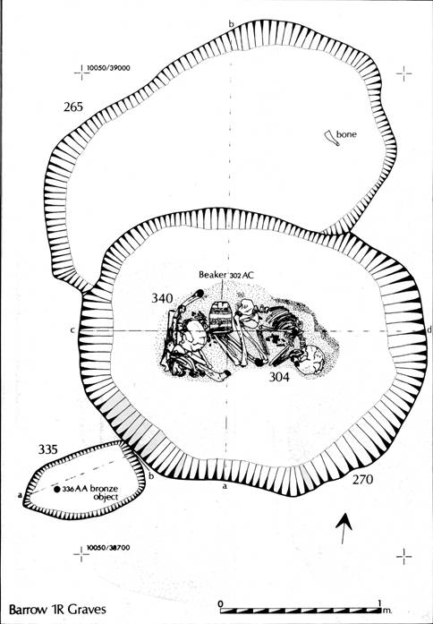
Figure 30. Barrow 1R: Grave plans: 270, 265, 335
1R335 (Figs. 30 and 31)
This was a very small ovate pit which cut the primary grave 1R270 on its south-western side. The pit, which if a grave could only have held an infant burial, contained a small copper alloy button-like object (1R336 AA). No bone or other artefacts indicating the function of the pit were recovered.
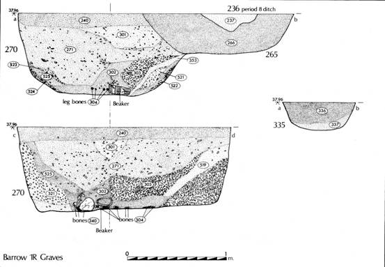
Figure 31.
Barrow 1R: Grave sections: 270, 265, 335
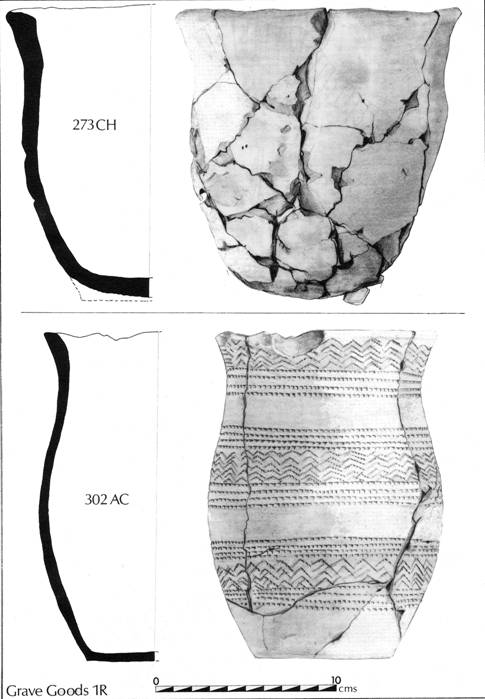
Figure 32.
Barrow 1R: Pots 302, 273.
1R272 (Figure 33)
A sub-rectangular grave pit located to the south of 1R270, cut through the Period 3A post-pit 1R256 and was sealed by the mound. It contained the badly preserved skeleton of an adult male aged more than 35 and possibly even 45. The surviving long bone fragments suggested that the burial had been laid out in a crouched position with the head to the east. An undecorated Food Vessel (1R273 CH, Figure 32) had been placed just behind and to the left of the cranium. A worked flint blade and a point (1R273 CC and CD, Figure 34) and a copper alloy awl (CB) were placed at the left side. As in grave 2C40, Barrow Cemetery 2, they may have been contained in a small bag. Also contained within the fill 1R273 were bone fragments of an infant.
Copper alloy awl or pin: AM No. 832971 SEM Stub A406 Ref. No. WH 82 R273 CB
Composition of metal - the object has a gold rich layer on a corroded core. It may have been gold plated bronze. Alternatively it may have been debased gold, possibly with an enriched surface, in which case its present condition would be due to burial effects (P. T. Wilthew, AML Report 4255).
Associated wood: possibly Alnus sp or Corylus sp. (Jacqui Watson, AML Report 4255).
Two further possible grave cuts were isolated within the central area, 1R267 and 1R338, neither of which contained any bone; both extended beyond the limit of excavation to the west.
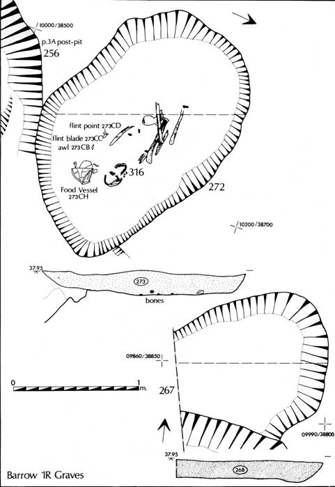
Figure 33.
Barrow 1R: Grave plans: 272, 267.
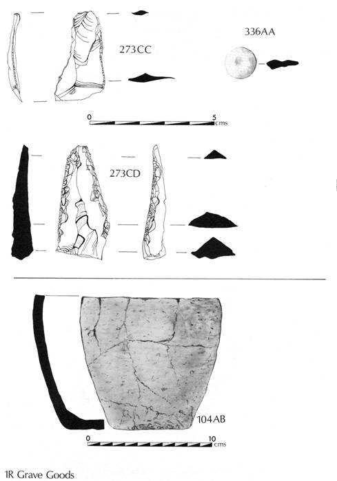
Figure 34. Barrow 1R: Grave goods (flints).
Secondary Burials
The narrow space between the inner ring gully and the outer ditch contained seven definite and one possible grave pits, four of which were in a group on the northern side of the barrow.
1R177 (Figure 36)
The grave was aligned north-south, placed midway between the two ditches on the eastern side of the monument; it was very shallow and contained no surviving bone or body staining. At the northern end on the eastern side it contained the very fragmented remains of a Food Vessel (1R178 AN, Figure 35) standing upright in the base of the grave. The pot, which was undecorated, was badly crushed and distorted.
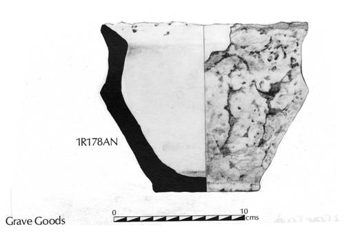
Figure 35.
Barrow 1R: Grave plans: 163, 177.
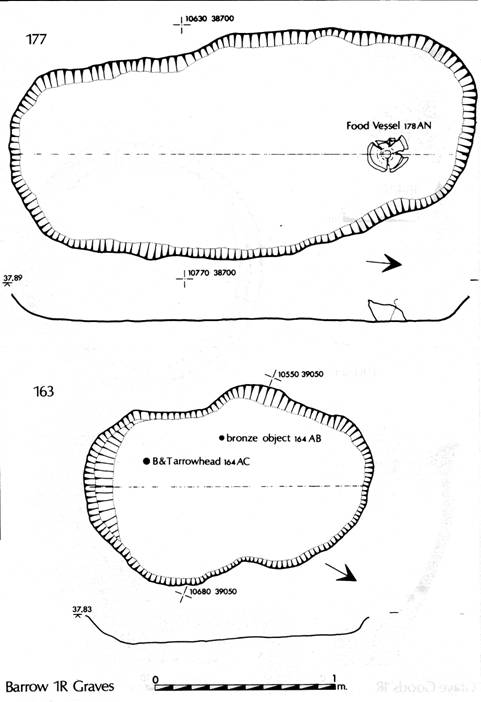
Figure 36. Barrow 1R: Grave plans: 163, 177.
1R163 (Figure 36)
1R163 lay to the north of 1R177, and was a shallow sub-rectangular cut; again containing no surviving bone or body staining. Its function was indicated by the presence of a barbed and tanged arrowhead
(1R164 AC, Figure 37) and a small fragment of copper alloy (1R164 AB).
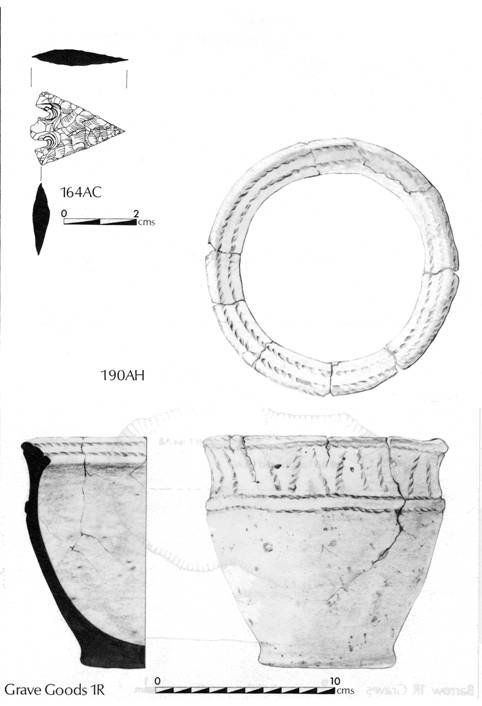
Figure 37. Barrow 1R: Grave Goods 190 (pot) 164 (arrowhead).
1R189 (Figure 38)
A small ovate grave, 1R189 was situated adjacent to the outer ditch on the north-east side of the barrow and contained an inverted Food Vessel (1R190 AH, Figure 37) placed against the eastern side of the cut. The size of the cut suggests that though no bones were recovered it probably contained the burial of a child.
1R198/223 (Figure 38).
1R198 was a small ovate cut on the northern side of the barrow, located between the inner ring gully and the butt end of the period 6 ditch 1R919, which contained a second smaller sub-rectangular cut 1R223 in the base. This lower cut. which was well defined, appeared to represent a primary grave, the top of which had subsequently been entirely cut away by 1R198. It contained fragments of bone, 1R224, including most of the skull, of a small child aged 3-6 years. The burial was accompanied by an upright Food Vessel (1R224 AK, Figure 39) positioned at the eastern end of the cut. 1R198 above, contained a few small fragments of bone including teeth apparently derived from the lower feature, no other bone was recovered. It did however contain an inverted Food Vessel (1R199 AF, Figure 39) positioned above and slightly to the south of the vessel in 1R223 below. It is arguable that this cut could have contained a child burial and that the upper grave was cut to the level of the lower Food Vessel at which point the second burial was inserted causing only slight disturbance of the grave below. The generally poor levels of bone preservation mean that it is impossible to confirm or discount the suggested sequence.
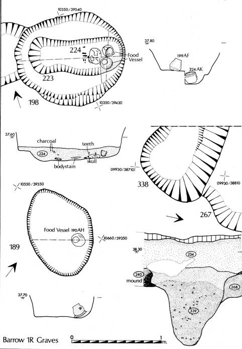
Figure 38.
Barrow 1R: Grave plans: 198, 338, 189.
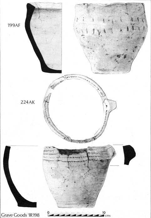
Figure 39. Barrow 1R: Pots 199, 224.
1R299 (Figs. 40 and 41)
This was a shallow trapezoidal cut located to the north of the central area which, since it cut through the inner ring gully, must represent a secondary grave; it contained the fragmentary remains of the skull and long bones of an adult male, 1R309, aged20-30. The position of the surviving bones indicated that the burial had been laid in a crouched or contracted position with the head to the cast. The burial was accompanied by an edge-retouched flint knife (1R300 AF, Figure 34) and a bronze object (1R300 AA). The grave fill, 1R300, also contained a number of very small bone fragments possibly from an infant or child; these may be residual and derive from the disturbance of 1R223 or 1R298, both of which are nearby.
1R297 (Figs. 40 and 41)
Located on the northern side of the monument where it cut through the butt end of the secondary inner ring gully, was a shallow sub-rectangular grave. It contained poorly preserved bones of an infant aged 2-4, 1R298, in which only the skull was substantially preserved. The burial was unaccompanied.
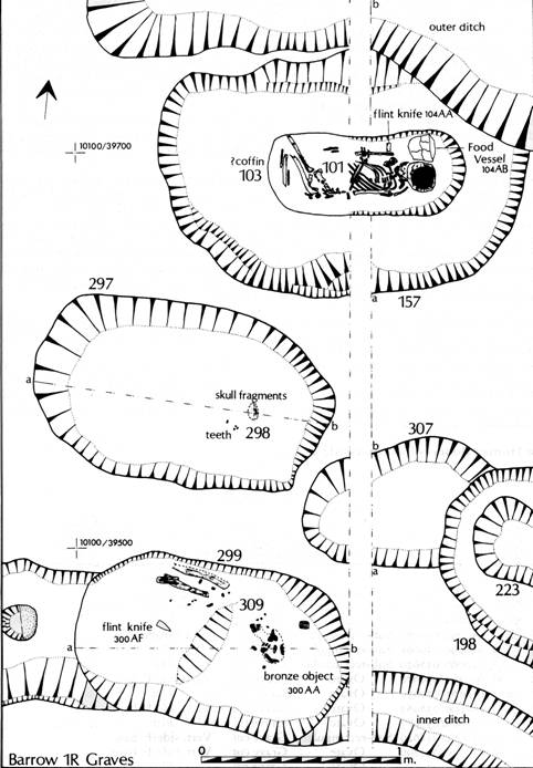
Figure 40. Barrow 1R: Grave plans: 297, 157, 307, 198, 299.
1R157 (Figs. 40 and 41)
1R157 was cut through the inner edge of the northern butt end of the outer barrow ditch, and had in turn been cut along its northern edge by the butt end of a Period 6 trackway ditch. The sub-rectangular grave pit contained the flexed burial, 1R101, of a child aged 7-9. The body, placed with the head to the cast, was accompanied by a small undecorated Food Vessel (1R104 AB, Figure 34) lying on its side in the angle between the left shoulder and the cranium, and a worked flint (1R104 AA, Figure 34) placed adjacent to the pot. The skeleton was contained by a distinctive fill with a 'U-shaped' profile indicating that the body had been contained in a small coffin, possibly tree-trunk type, defined by the backfill of natural sand and gravel. Also contained within the backfill were a number of bone fragments from an adult, probably a female.
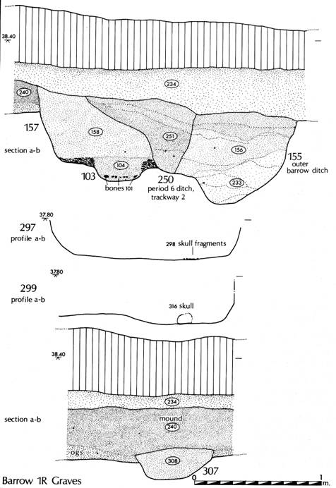
Figure 41. Barrow 1R: Grave sections 297.
Isolated Burials and Flat Graves
1F143 (Figure 43)
A small quantity of calcined bone which included human fragments, was located on the eastern edge of area 1F in a plough-damaged area. The deposit was so truncated that detailed interpretation was impossible.
1S776 (Figure 43)
The earliest of all the Beaker graves was located 75m to the north of Barrow 1M. The large ovate grave, which had cut through the Period 2 ditch 1S779, contained no surviving bone but did contain a small Beaker, 1S777 AA (Figure 42), which itself contained a small flint blade. There was no evidence of any enclosing ditch or associated mound with this burial and it must be viewed as an indicator of flat cemetery traditions.
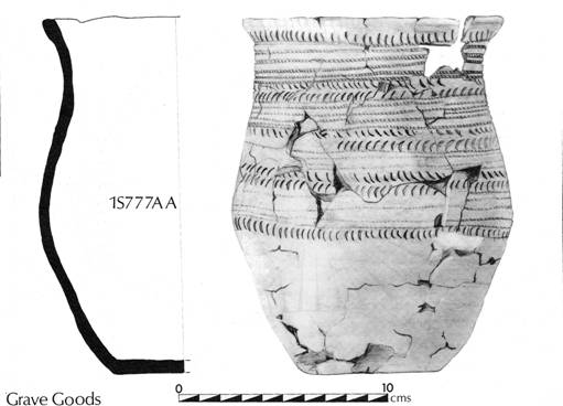
Figure 42.
Beaker 1S777
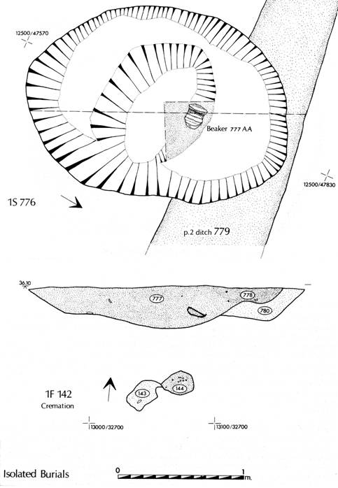
Figure 43. Plans of IS776 1F142
The Human Bones by Jean Dawes (M2/2 I-22)
BARROW CEMETERY 2
In contrast to the central part of Site 1, areas 1A, 1HE and parts of the areas examined on Site 2 had been subjected to erosion by the plough, possibly coupled with wind erosion. The barrow cemetery postulated in this area has since been confirmed by excavation.
During the salvage excavation of 1HE by Dent, a Beaker burial 1HE18 DW (Figure 44), was located which had been subsequently cut through twice by Period 7 burials 1HE10 and 1HEI7. This relationship, together with the discontinuity of the Period 6 ditches in area A, implies the presence of some sort of mound associated with the Beaker burial even though the scale of it must have been very small. A barrow cemetery postulated in this area has since been confirmed. Five metres to the south of this feature a quantity of cremated bone associated with 6 sherds of Bronze Age pottery were located at the base of the windblown sand deposits, perhaps indicating the presence of a further burial from this period.
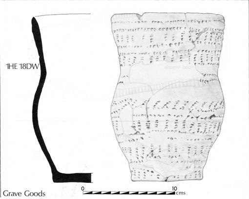
Figure 44. Beaker 1HE18
Fifty metres to the west-south-west of burial 1HE18, a ring gully 1A21 enclosing an area c. 8 m in diameter, was cut by a single burial, 1A18. The ditch, which extended beyond the limits of excavation, survived to its greatest depth against the field boundary which marked the southern edge of the site. The ditch fill, a homogeneous sand, displayed no indication that the ditch had been structural and contained no domestic debris besides a few flint flakes. Burial 1A18, in a prone position with the hands possibly tied together beneath the pelvis, was unaccompanied, and appeared to have been buried alive. The bone was unusually well-preserved and has a single radiocarbon date of HAR6517 2280 ± 80bp (330bc).
Its presence indicates a continuity of function that might already be suggested from the incidence of the early Bronze Age and Anglian cemeteries on the same ground; furthermore, it demonstrates the potential of radiocarbon dating for the identification of periods of activity that would otherwise have remained unnoticed. Detailed discussion of this burial will be included in the second report, on completion of excavation on Cemetery 2.
Fifty metres to the south on Site 2, a single grave 2C40 (Figure 45) indicated the presence of a further barrow. This grave, cut to a depth of 0.45m was aligned east-west and contained no surviving bones. Fragments of tooth enamel were recovered from a patch of ill-defined body staining, 2C42, and indicated that the burial had lain with the head to the west. The burial was accompanied by two small Food Vessels (2C42 AC, Figure 46; and AD, Figure 47), a plano-convex flint knife (2C42 AB, Figure 46) and a copper alloy awl (2C42 AA, Figure 46). They were all located on the northern side of the grave cut at the western end, where the juxtaposition of the awl and knife indicate that they had been contained in a bag. Thirty-five metres to the east of this grave, part of a ring gully was located. Excavation currently in progress has revealed that 2C40 lay just beyond the northern side of a barrow which has yet to be excavated, whilst the ring gully discovered in 1981 was part of a barrow ditch within which two Food Vessel inhumations, a Food Vessel accompanying a cremation, and a second unaccompanied cremation were discovered in 1985. Excavation of this area, 2BA, is currently in progress and will be discussed in full together with the Period 7 cemetery in the second report. At least two barrows in this area remain to be excavated during 1986.
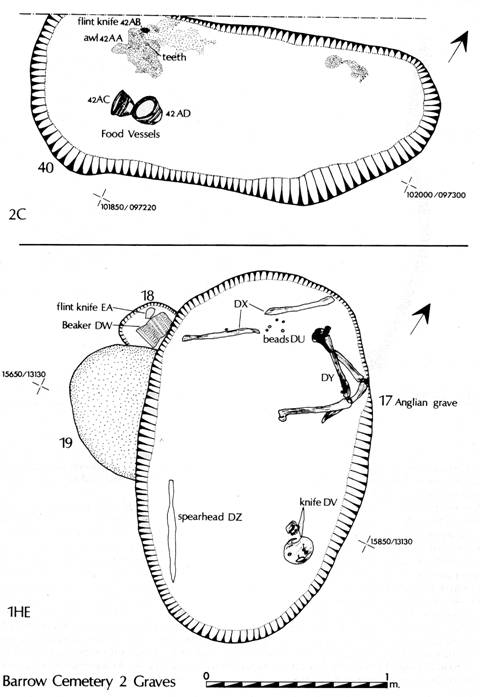
Figure 45. Plans 1HE18 2C40
Human Bones by Jean Dawes (M2/22)
THE POTTERY by T. G. Manby (see M2/23-49)
The sherd material and accessory vessels for the burial series at Heslerton is an extensive one.
Description of the sherd material and the individual pots occurs under the site areas in the microfiche and introductory comments are provided below. The bibliography has been included in the microfiche.
The Beakers
The Beaker pottery comprises both scattered sherds derived from occupational activity and complete vessels accompanying burials. This concentration on the sands at the foot of the Wolds has a parallel in the concentration to the east around the spring head at Staxton Corner. This consists of burials, some with Beakers of N/NR (Brewster 1951), S1 and S4 types (Stead 1959) in Willerby parish and another N/NR in Flixton (Dunning 1933). AOC Beaker sherds were associated with possible post-holes at Sammy Ridings Pit, Flixton and Granger's Pit, Staxton (pers. comm. T. C. M. Brewster), sherds from Sherburn (Roman Malton Museum Collection) and the N2 Beaker from Scampston (Clarke 1970, No. 1381, Figure 501). The types of Beakers from Heslerton and Staxton Corner indicate activity at these localities throughout the full chronological ranges of these vessels. Apart from the Step 3 Beaker (1S777 AA) the vessels closely parallel in profile and decoration Beakers from the Yorkshire Wolds and fit in to the typological scheme for the Yorkshire area (Lanting and van der Waals 1972, 39-40, Figure 3).
Small Beaker sherds were well scattered in the mound and ditch siltings of Barrow 1L and a small number were present in Barrow 1M.
The Accessory Vessels -Comments
IS777 AA (Figure 42)
This is a most interesting vessel with unique features for the Yorkshire Beaker area. Its full reconstruction would modify thoughts on its parallels and affinities; an immediate consideration was to compare the decorative motifs and layout to the PFB vessels of the Netherlands Beaker series where the absence of ornament below the shoulder is a characteristic aspect. The Heslerton vessel lacks the moulded base and is comparable with the South Cave Beaker that has horizontal cord lines down to the shoulder with a fringe of diagonal strokes below (Clarke 1970, No. 1259). The Raindale, Pickering Beaker (Clarke 1970, 1362) has horizontal comb lines confined to the upper two thirds but differs in profile from our vessel. Also to be taken into consideration must be a Beaker from Huggate and Warter Barrow 264 (Mortimer 1905, 317, Figure 945); this has a high rounded shoulder, short neck and outcurving rim. The decoration extends down to mid-height and consists of alternate bands of horizontal lines and herringbone; a zone of herringbone is inside the rim (Hull Museum 215.42).
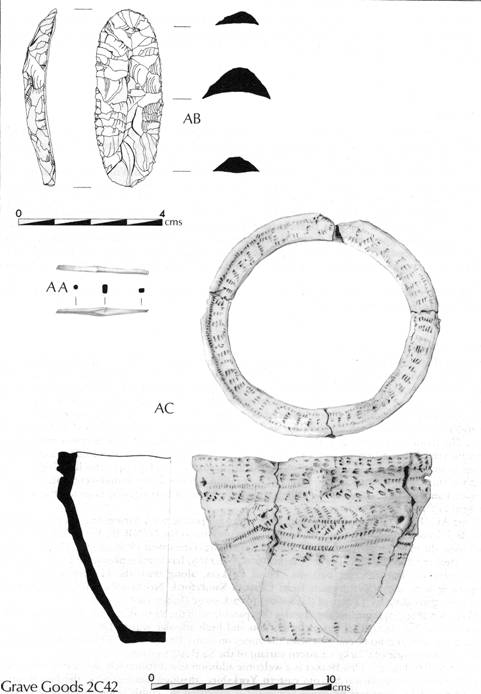
Figure 46. Grave
goods 2C42AC
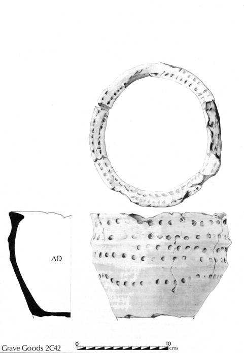
Figure 47. Grave goods 2C42AD
1R302 AC (Figure 32)
This vessel is distinctive in its tall profile with flaring rim. Its best parallel in shape and decorative motif of zones of vertical herringbone is the N/NR Beaker (Clarke 1970, No. 1369) from the massive shaft grave of Rudston Barrow 62 (Greenwell 1877, 253-57; Pacitto 1972). A second Beaker from the same grave (Clarke 1970, No. 1368) has a similar profile and arrangement of decorative zones but different patterns. These Beakers, along with the Heslerton example, are comparable with the N/NR vessels from Chatton Sandyford, Northumberland, post-dating the stake-holes providing a C4 date of (GaK-800) 1670 ± 50 bc (Jobey 1968, 5-30).
1M345 AA (Figure 27)
In profile the vessel is comparable with the S4 Beaker from Rudston Barrow 63 (Clarke 1970, No. 1373) that has a rim cordon and high angular waist. The deep bands of cross-hatching on neck and body contrast with the zones on many late Beakers. The cylindrical neck and cordon are diagnostic of Clarke's Eastern variant of the S2 Beaker group.
1L20 AA-BB (Figure 19)
This Beaker is a welcome addition to a distinctively decorated series of late Beakers distributed southwards from eastern Yorkshire, through Lincolnshire, the Fen Basin and East Anglia. The characteristic panel ornament is executed by comb impressions or incision on normal Beakers and a wider range of shapes with handles. The motifs are mixed with horizontal zones, and the panels are simple lozenges and elongated hexagons (Clarke 1970). In terms of decoration this Beaker is closely comparable with S4 Beakers from:
Staxton (Clarke 1970, No. 1392) Incised. Vale of Pickering
Acklam 214 (Clarke 1970, No. 1211) Incised. Wolds
Folkton 242 (Clarke 1970, No. 1280) Comb. Wolds
Octon (Brewster forthcoming) Comb. Wolds
Handled Pickering (Clarke 1970, No. 1360) Incised. Moors
All these display cross hatched hexagonal panels; at Staxton, Acklam, and Pickering in combination with cross-hatched horizontal bands. Thus in terms of the sole use of hexagons and their interlocking layout to produce the reserved structure in between, it is the Folkton and Octon Beakers that are indicative of the Heslerton Beaker. The laying out of the pattern would have required experience and, an understanding of mathematical proportions.
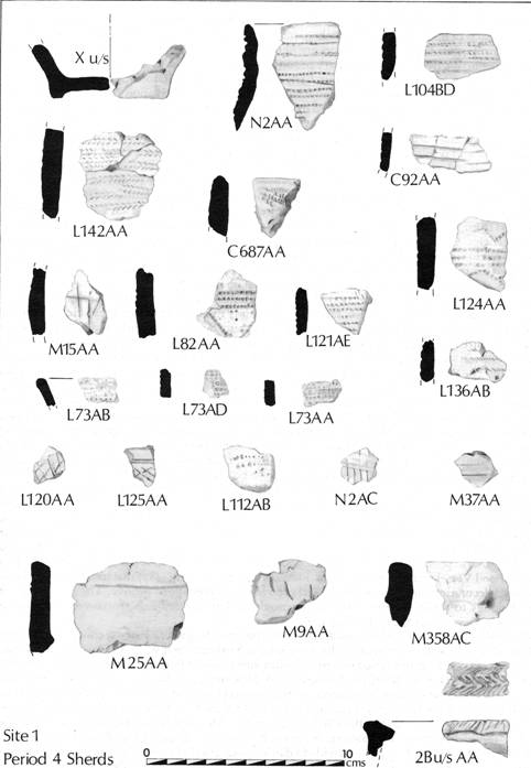
Figure 48. Beaker sherds.
The Food Vessels
The Heslerton site is notable for the number of Food Vessels recovered. Previously the only vessel known came from Kirby Misperton (Yorkshire Museum 1189.47) in the middle of the Vale and the sherds from Granger's Pit, Staxton (T. C. M. Brewster collection) at the foot of the Wolds. Eastern, Yorkshire has the greatest concentration of Food Vessel finds in the British Isles, totalling 355 recorded vessels, 236 coming from the Wolds and 101 from the North York Moors. Not included in these figures are Enlarged Food Vessel urns and the miniature Food Vessels of the accessory cup series. The Food Vessels are essentially known as accessory vessels with burials, the majority inhumations, and only rarely did they contain cremated bones when associated with the minority cremation rite. The vessels are almost entirely of the Yorkshire Vase series, first defined by Abercromby into six types by shape with six sub-types and the exotic handled and footed vessels (Abercromby 1912, I, 93-94). It was noticed that all the types were contemporary; a conclusion confirmed by Mrs M. Chitty's study of Food Vessels from Yorkshire (Kitson-Clark 1937). Before the advent of C14 dating the only avenues available for the interpretation of the vast array of pottery were typology and associations, both ritual and material. A regional study of the Peak District Food Vessels in comparison with those of Yorkshire produced an evolved development classification that reduced Abercromby's types to five, each divided into stages, and three variant types (Manby 1957). Regional preferences in shape and decoration are demonstrable and offer a profitable field of research. The national approach to Food Vessel classification extended Abercromby's Groupings into:
1. Yorkshire Vases
2. Southern English Food Vessels
3. Irish Bowls
4. Irish Vases
These Groupings overlap in the British Isles (ApSimon 1958) and the study of their cultural associations (Simpson 1968) demonstrates that pure cultural assemblages are not present for any Grouping. Only plano-convex flint knives are exclusive to Food Vessels; all other flint, stone, jet, and bronze types were shared with contemporary Beaker and Urn ceramic associations.
The Vase series of Food Vessels in Great Britain have been given descriptive groupings based on shape; Bipartite including shoulder grooved and lugged types (Abercromby types 1 and 3); a Ridged Group, especially tripartite forms (Abercromby type 2); Bucket Group (Abercromby types 4 and 5) (Burgess 1980, 86-89). Within these groupings northern and southern sub-groups are also recognisable. The lugged Food Vessels are not found in Southern England and there is a tendency to refer to these as 'Yorkshire type'; however they are one of the three basic form of the Eastern Yorkshire regional distribution. The regional characteristics of Food Vessels have been demonstrated for Wales (Savory 1957), the Peak District (Manby 1957), Northumberland and Durham (Gibson 1978), and South-western Scotland (Simpson 1965). The sheer number of Food Vessels from Yorkshire has deterred corpus publication but the characteristics of this concentration and other regional groups in Northern England and Southern Scotland has recently been summarised (Pierpoint 1980, 63-123). A social approach to the study of Food Vessels and their burial associations was developed by Pierpoint that also considered the character and quality of the vessels. The traditional typological concept of degeneration of the shape, from fine to coarse, was rightly contrasted with the existence of higher quality vessels of finer fabric and modelling, intensive decoration, and novel features, being the work of specialist potters. Such quality pieces are likely to have been produced for significant interments and are distinctive from ordinary pottery production.
Food Vessels are the most numerous Early Bronze Age ceramic form accompanying burials in eastern Yorkshire; however, both older accounts and modern excavation demonstrate that only a minority of interments were accompanied by pottery. Certainly amongst inhumation burials in Wold barrows only one in four have accessory vessels deposited with them. The situation on the Moors cannot be accurately determined as the acid soil conditions in many barrows has dissolved uncremated human bone and results in a biased majority cremation rite association for Food Vessels.
Irish bowls and vase group vessels (Waddell 1975) are not confined to Ireland and typical shapes and decorative elements are present in Wales (Savory 1957, 205-07), the Peak District (Manby 1957, 9-10), South-western Scotland (Simpson 1965, 26-33), and Central Scotland (Pierpoint 1980, 89, PL. N-IV). The 'Irish' element in eastern Yorkshire was considered by Kitson Clark and, apart from the bowl from Sawdon, was largely seen in terms of false relief decoration on normal Yorkshire Vase forms (Kitson Clark 1937). A further instance is the divided lugs on the Peasholme, Scarborough Food Vessel (Scarborough Museum 862.38). The use of comb impressions so favoured in the Irish Groups is a rare technique employed on eastern Yorkshire Vessels (Pierpoint 1980, Figure 4. 6-7). 'Irish' elements also appear in the Northumberland vessels (Gibson 1978).
In view of the vast numbers of Food Vessels of both the Yorkshire and Irish Groups very few C14 dates are available (Gibson 1978, 46, Figure iv: 6). Certainly too few to provide a realistic understanding of the development of the various groupings of Yorkshire, Southern English, and Irish Food Vessels. The Yorkshire Food Vessel Group has its origin in the northern Peterborough tradition represented by the Rudston style in Yorkshire (Manby 1975, 59) and that of Meldon Bridge further north (Burgess 1980, 39). The decorative traits of these late Neolithic styles are continued in the respective regional Food Vessel styles of Yorkshire and Southern Scotland. Burgess sees Food Vessels first being deposited with burials in his Overton Period in Southern England c.2000-1650 BC and persisting into the succeeding Bedd Branwen Period c. 1650-1400 BC (Burgess 1980, 80-84 and 116). In eastern Yorkshire only one radiocarbon date has been obtained from charcoal associated with a Food Vessel cremation at Garton Slack Site 7 (HAR-1236) 1600 ± 70 bc (Brewster 1980). This is close to the dates from Amesbury (NPL 75I) 1640 ± bc; Aberdour Road, Dunfermline (SRR 292) 1631 ± 40 bc (CloseBrooks et al.); Trelyston IB4 (CAR-280) 1695 ± 70 bc and NB3 (CAR-283) 1600 ± 60 bc (Britnell 0982); and the mean of the two dates from Harland Edge, Derbyshire (BM-210) 1750 ± 150 bc and (BM-178) 1490 ± 150 bc (Riley 1966). A later group of dates are (UB-450) 1460 ± 165 bc for a burial with a fine quality vessel at Tallington, Lincs. (Simpson 1976) and (HAR-2677) 1350 ± 50 bc for a dugout coffin containing a cremation with Food Vessel at Dygsgwlfa Fawr in Wales (Britnell 1982), 189). The Tallington vase so closely resembles that from Garrowby Barrow C97 (Mortimer 1905, 143, Figure 280) in profile and decoration that both are the work of the same potter; the same may be said for the Food Vessel from Wetwang Slack Site 4 (Brewster 1980, Figure 487) that has the same false relief and cord decoration but lacks the additional groove below the lugged groove. The Dysgwylfa Fawr vase belongs to the Irish series, elaborately moulded with divided lugs, furrowed and false relief decoration (Savory 1957, 299, E1. Figure 9.9).
The hollowed-out tree-trunks used as a coffin for the Dysgwlyfa Fawr cremation belongs to a group of early Bronze Age burials well represented in Yorkshire and Wessex (Elgee 1949 and Ashbee 1957). Food Vessels accompanied tree trunk coffin interments at Pockley and West Tanfield in North Yorkshire and at Bishops Waltham, Hampshire (Ashbee 1957, 153, Figure 9). Contemporary with Food Vessels but without ceramic association are the monoxylous coffins found in eastern Yorkshire at Gristhorpe and Willy Howe, Cowlam that have provided the C14 dates of (HAR-4995) 1670 ± 70 bc and (HAR-4424) 1640 ± 46 bc (Brewster forthcoming). Monoxylous coffins were used over a long period; the earliest from Cartington, Northumberland was associated with a Beaker, from the description of AOC class, and has provided a date of (GU-1648) 1840 ± 65 bc (Jobey 1984). The latest monoxylous coffins have interments in Wessex with Aldbourne-Edmondsham assemblages such as the Hove, Sussex coffin that has provided a radiocarbon date of (BM-682) 1239 ± 46 bc.
The recognition of tree trunk coffins was based on favourable conditions for the preservation of wood such as water-logging before the advent of modern excavation techniques. The use of such coffins for prestigious burials must have been more widespread than available records indicate. Parallel with the monoxylous coffin burial rite in England are the tree trunk coffin burials of Northern Europe in the Netherlands, Northern Germany, and Denmark (Coles and Harding 1979, 295-308).
The Accessory Vessels -Comments
1L56AA (Figure 19)
A well modelled vessel of almost lobular form but the arrangement of the decoration perpetuates the shoulder dividing neck from body.
1L147AA (Figure 18)
This vessel is outstanding amongst the Food Vessels of Eastern Yorkshire by virtue of the combination of comb and false-relief decoration. Both are minor techniques of ornament (Pierpoint 1980, 76). The nearest parallel is the fragmentary vessel from How Tallon, Barningham on the Pennines above Teesdale in north-western Yorkshire (Coggins and Clews 1980, 24, Figure 6). Comb and false-relief are a major element of the "Irish" Food Vessel Group, both bowl and vase forms. The combination is a major diagnostic feature of the Food Vessels of Clyde-Forth-Argyll distribution in Scotland (Pierpoint 1980, 70-89, Figs. 4 and 6-7) distinguishing them from Yorkshire, Peak District, and Northumberland distributions.
A further aspect of more immediate local connections are the combination of beaker derived motifs on the lower part of the body of this vessel consisting of vertical herringbone zones, filled bar chevrons and filled standing triangles. All these motifs executed in comb were widely employed on S-Beakers in eastern Yorkshire (Clarke 1970, Nos. 1283, 1293, 1298, 1335, and 1400), that is Lanting and van der Waals Steps 5-6. Beaker derived motifs are not a major element of Yorkshire Food Vessels but the direct imitation in comb of such traits are a direct indication of the contemporary nature of late Beakers and Food Vessel production in the region,
1R190AA (Figure 37)
A simply decorated vessel, the diagonal impressions in contrast with the intensive decoration in zones that is usual on Yorkshire Food Vessels. Apart from the diagonal, the shape and thick horizontal cord lines on bevel, rim and shoulder closely resemble a vessel from Mortimer's Life Hill Barrow 28, on the Wolds north of Driffield (Mortimer 1905, 200, Figure 495).
1R224AK (with 1R199AF; Figure 39)
This is an uncommon form of Food Vessel, outstanding because of the single lug attached immediately below the lip. Single lugged vessels have been found in East Yorkshire previously at Driffield Barrow 278 and Towthorpe Barrow 26. The former site was Howe Hill, Sunderlandwick and decorated with cord line impressions that also occur on the shoulder and broad internal rim bevel (Mortimer 1905, 296, Figure 296). The second vessel accompanied a flexed inhumation and has a broad oval lug below the rim decorated with a herringbone pattern on its exterior and upper surface with cord line impression. The same decoration was applied to the rim bevel, a zone immediately above the base and the upper half of the vessel where horizontal lines divided the three uppermost rows (Mortimer 1905,12, Figure26)
A vessel accompanying a pair of inhumations at Elton, near Peterborough, is similar in profile and decoration to the Heslerton vessel but the lug lies just below the decoration zone and is conical in profile (Greenwell 1877, 15, No. 39). A similar plain cup with a single horizontal lug comes from Upper Hove Park Barrow 24 near Swaffham, Cambridgeshire (Cambridge University Museum Acc. No. 214984). A globular vessel from Rothwell, Northants, has a single vertical lug on its rounded shoulder (Cambridge University Museum Acc. No. 18.206). A final example comes from a bowl barrow at Bratton, Wilts, excavated by Colt-Hoare, accompanying a cremation and a 'large urn' and is closer in profile to the Towthorpe vessel but the horizontal lug on the shoulder has a vertical perforation. The cord line decoration on the rim bevel and upper half of the vessel is one of the more complex kind seen on the Towthorpe example (Annable and Simpson 1964, 63, No. 497).
All these are basic vessel forms not greatly responsive to typological developments other than the lug and the nature of the decoration. They may be placed in a wider group of exotic Food Vessels that includes footed (Manby 1969, 276), handled and lidded forms whose distribution is concentrated in the Eastern Midlands and Yorkshire. On the other hand, the Heslerton and Elton vessels must be compared with the Durrington Walls style Grooved Ware assemblages at Carnaby Top and North Carnaby Temple where the same vessel shapes, lugs, and cord decoration are present (Manby 1974). The chronological range of this Grooved Ware style and Food Vessels is still based on a small number of dates but the indications of partial contemporaneity of these ceramic types are evident (Gibson 1982, Figure 4). While most elements of Yorkshire type Food Vessels derive from Rudston style Peterborough Ware, a contribution from the Grooved Ware repertoire would be possible
2C42AC and AD (Figs. 46 and 47)
A pair of Food Vessels accompanying the same interment is a scarce association in Yorkshire but proportionately more frequent in the Peak District (Manby 1959, 4-5). Such associations demonstrate that the variant types of Food Vessels are contemporary in use and parallel in their development. In Eastern Yorkshire vessels of Types 1c and 4(n) accompanied a cremation deposit at Towthorpe Barrow 1 (Mortimer 1905, 2, Figs. 2 and 3,) the only instance of a paired accompaniment from the Wolds. In North-east Yorkshire a cremation at Brotton, on the Cleveland coast, had vessels of Type 2(iv) and 3(v) (Hornsby and Stanton 1917, 263). The only other dual association of Food Vessels in eastern Yorkshire were single vessels at the heads of a pair of inhumations laid side by side on the floor of a central barrow grave at Cawthorne (Bateman 1861, 207-08), of types 1a(n) and 2(n) (Sheffield City Museum J93. 794 and 825).
In both vessels from the present grave the potter has made the neck and shoulder groove of equal proportions and in the Type 1b vessel has inserted lugs into the neck in addition to the shoulder groove. This variant arrangement is rare in eastern Yorkshire but two groups can be recognized. The first consists of two vessels with the narrow shoulder groove holding the usual four lugs, the deep neck above has a single large lug. The fine fabric of both vessels and their decoration indicate they are likely to have been the work of the same potter although the findspots are on opposite sides of the Vale of Pickering, 30 km apart, at Folkton (Greenwell 1890, 12, Figure 4) and Cawthorne (Pierpoint 1980, 119, PI. VNI). The second group to which the Heslerton vessel belongs have neck and shoulder groove of equal proportion and the four lugs in each are alternately spaced. Type 1b vessels of this variant come from the Wolds at Thorpe (Rudston) (Abercromby 1909, 1, Figure 135), Riggs 41 (Mortimer 1905, 181, Figure 456) and Garton Slack C37 (Mortimer 1905, 2io, Figure 5i5; Pierpoint 1980, PI. IX). Also from the northern side of the Vale of Pickering from Ampleforth (Yorkshire Museum ION.47), and Seamer Moor (Abercromby 1909, 1, Figure 39) has provided a further variant with two shoulder grooves with lugs below a normal neck (Coombs, forthcoming). This variant Type 1b must be placed in the exotic grouping of footed, lidded and handled Food Vessels; along with the rarer Type 1c their distribution is confined to Yorkshire and the East Midlands. They are absent from the regional assemblages of the Peak District, Southern England, Wales, Northumberland, and Scotland, but strangely the 1b form appears in the Enlarged Food Vessel-Encrusted Urn series of Northumberland, Wales, and Scotland (Cowie 1978).
DISCUSSION
The early Bronze Age burials and barrow series from Heslerton provide an important body of new data which suggest that traditional views regarding the distribution, topographical location, constructional sequence, and function of the barrow mound itself require detailed reassessment. The discovery of an isolated and typologically very early Beaker flat grave (1S776) 80 m to the North of Cemetery 1, together with a second similar grave containing a burial accompanied by a Beaker and a V-perforated jet button associated with Cemetery 2, when considered in the light of the Beaker flat cemetery located in a similar topographical position at Staxton (Stead, 1958), 10 km to the East, may indicate that the flat grave is less exceptional in this period than current evidence suggests. There may be some significance in the apparent early date of the Beaker from 1S776, with its continental attributes and local fabric; however without a C14 date little more can be said.
Aerial photography associated with the excavation has indicated that the distribution of ring-ditch features, the majority of which probably represent early Bronze Age barrows, is widespread along the southern margins of the Vale of Pickering (Figure 15). If this interpretation is correct, further such cemeteries must exist in the centre of the Vale situated on small gravel islands that would at this time have been isolated within an extensive tract of marshland to the south of the River Derwent. The topographical positions of these features, which are most frequently in groups, display a uniformity which must be a direct reflection of the early Bronze Age landscape.
Besides demonstrating a wide variety of topographical locations for barrows whether singly or in groups, aerial photography has indicated that the density of the distribution of these monuments in the Vale is at least as great as that found on the Wolds or the Moors where past research has been almost exclusively concentrated. The fact that none of the three barrows excavated in Cemetery 1, nor any hint of Cemetery 2, was visible from the crop mark record must be taken as an indication that those ring ditches recorded from the air represent only a small proportion of the total, more of which may be preserved beneath the aeolian sand deposits; the implications for any assessment of the early Bronze Age population are self evident.
The scale of the mounds of Barrows 1L and 1M was perhaps in comparison with barrows either on the Wolds or the Moors, and they would never have been very dominating features of the landscape; the mounds as excavated were almost intact. Barrow 1L showed no signs of plough damage of any period and that it became partially buried by aeolian sands soon after its construction is indicated by the survival of the spoil heap resulting from the digging of grave 1L2131 which cut through the fill of the barrow ditch. Both a Roman trackway and an associated field boundary gully partially respect the monument, the trackway cutting through part of the mound. After this period it appears that the mounds became completely sealed by aeolian sands. An examination of the sections through Barrow 1M indicate that since the early Iron Age, when a field boundary cut across the southern edge of the mound, there had been little damage to the surface of the mound. Adjacent to the field ditch to the north there was clear evidence of a headland, whilst to the south an area of leached soil seemed to derive from the presence of a hedge-bank above. In both these cases the volume of the surviving mound material was not markedly different from that of the ditch.
Work still in progress on Cemetery 2 has included the excavation of two additional barrows with at least one more example awaiting examination during 1986. The contrast between the monuments in the two cemeteries already indicated from the work on Site 1 and sample trenches on Site 2 has been confirmed. The discovery of three further Food Vessels and a further Beaker burial confirm the broad contemporaneity of the two cemeteries. Detailed discussion of this cemetery and the contrasts with Cemetery 1 will be forthcoming when excavation is completed and C14 calibrations returned, for publication in the second report; for now it will suffice to point out the principal differences. The barrows in both cemeteries feature mixed burial rites, and burials accompanied by Food Vessels or Beakers. Both cemeteries contain multiple burials in single grave pits, both sites include beaker flat graves, though in Cemetery 2 this evidence needs clarification. Structurally, however, the barrows display little in common, a situation no doubt exacerbated by plough damage over Cemetery 2, where no evidence of any surviving mound has so far been recovered. The dimensions of the ring ditches, which in both cases are slighter than those generally accompanying upland barrows, provide the most dramatic contrast. Where the ring ditch around Barrow 1M measured 28m in diameter and the smallest of the three barrows excavated in cemetery 1, 1R, was 17.5m, those in cemetery 2 were both smaller and of a similar size, 2BA264 measuring 12.5 m in diameter, 2BA174 measuring 11. 5 m. Whilst the scale of the monuments as a whole is smaller in Cemetery 2, the grave pits recently examined here were larger than any excavated in Cemetery 1; three out of the four contained coffins. The density of burials associated with each of the barrows in Cemetery 1, however, was far higher than that in Cemetery 2, where each of the two barrows so far examined contained only two grave pits.
A sequence based upon the single major primary burial beneath the centre of a mound into which secondary burials were cut has little to support it from Cemetery 1. Only in the case of Barrow 1R was there a major central burial (1R304); in the case of 1M there was some indication that there had been a burial near the centre of the inner ring gully, but the only surviving evidence was two fragments from the long bones of a child contained in a cut only 0.18 m deep. In the case of 1L there were no burials at the centre; in fact the primary burials, of which there were five, appear to have been arranged in an arc around the centre-point of the ring ditch. The density of the burials in each monument varied, with 1M having both the lowest density and a varied distribution. Detailed interpretation is hampered by the limited bone preservation particularly in this area; evidence of burials within the inner ring gully was limited to that described above. The only other certain burials in 1M were all located in the eastern half of the monument where they were concentrated adjacent to, and in one instance cut into, the outer ditch. There was sound evidence that the western half of the mound had been affected by flooding and associated erosion from the relict stream channel which here flowed between the two barrows 1R and 1M. In contrast to some of the later period field boundaries, which revealed that the extend of flooding during the late Iron Age or Roman period was such that silts and clays were deposited in ditch fills over 100 m from the stream channel, the extent of flood-borne deposits was limited to the western and north-western sides of the barrow, perhaps indicating occasional flash-flooding rather than regular and extensive floods.
The unusually high level of preservation of the mounds in Cemetery 1 is an important feature of the site, since as a result we are able to study the development sequence of each barrow to a degree not possible in plough damaged examples. In all cases the barrow mounds themselves represent a late feature in the development of the monuments, each of which had started as a flat cemetery, perhaps defined by an enclosing gully. This survived as the inner ring gully in 1M and 1R, within which were a number of graves, but in 1M it would appear to have been deliberately backfilled soon after it was dug. The source of backfill is not known but was certainly not the outer ditch which was largely cut into gravel. All three barrows contain examples of multiple interment in the same grave. The poor bone preservation, particularly in barrows 1L and 1M may have biased the record so that further examples of multiple interment could not be isolated.
The earliest dated burial was beneath barrow 1R, constructed on the western bank of the stream which had provided a focus of activity during the preceding periods. A C14 date Of 2110 ± 80 bc for the redeposited burial 1R340 is considerably earlier than date for the N/NR Beakers from Chatton Sandyford (1670 ± 50 bc; Jobey 1968), which most closely parallel the Beaker accompanying 1R304 which was inserted into the grave pit prior to the construction of the mound. Further C14 dates from 1R304, 1R316, 1R309, and 1R101 should help isolate the date range for the monument in some detail. The presence of six Food Vessels, including an undecorated example in grave 1R272 which was sealed by the mound, indicates, on the basis of the very small number of Food Vessel C14 dates, that the flat cemetery stage may have lasted for hundreds of years before the mound was finally constructed.
A feature of this barrow was the number of disarticulated bones distributed widely in the grave fills, grave cuts 1R270, 157, 272, 299, and within the barrow mound 1R240, all containing disarticulated skeletal fragments; only in the case of grave 1R270 was there any clear evidence of the source of some of these fragments. This grave, besides containing the articulated burial 1R304 and stacked remains of 1R340, contained both partially articulated and completely disarticulated fragments derived from at least one other burial throughout the grave fills. A series of postholes sealed beneath the northern side of the mound of this barrow may derive from a mortuary structure of some type, but without further examination of the remainder of the monument, which extended beyond the limit of excavation to the west, the interpretation of these features remains elusive.
Considering the very large area excavated at this site it is remarkable that no settlement evidence contemporary with the barrows has come to light. That the area was used for limited agriculture prior to the construction of the barrows was indicated by the Period 2 gully sequence, sealed by barrows 1L and 1M, and confirmed by McPhails examination of the soils in the gully beneath 1L (M2/01-10). A ring gully, 1C454, measuring 5 m in diameter with possible stake-holes in the base was originally interpreted as an early Bronze Age structure on account of a plano-convex flint knife, the only find in the ring gully, and Beaker sherds found in the immediate vicinity. Two similar ring-gullies related to the Period 6 trackway in area 1S support an alternative suggestion that this feature, which was already truncated during stripping of the overburden prior to the start of the excavation, was a haystack gully of a much later date. Recent work on Site 2BA has revealed a large ditched or palisaded enclosure sealed by one of the barrows of Cemetery 2, but this feature remains as yet undated, although further excavation in 1986 may produce firm dating evidence.
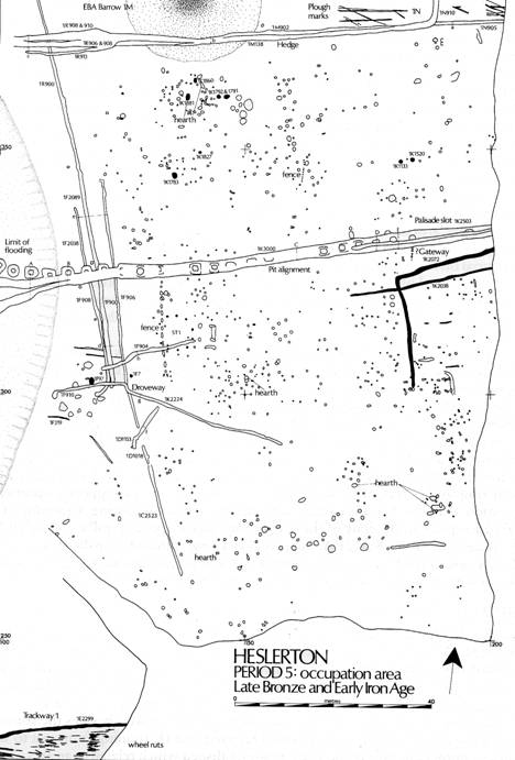
Figure 49. Period 5 plan.
PERIOD 5: THE LATE BRONZE/EARLY IRON AGE
After the Period 4 Barrow Cemeteries went out of use, the site was evidently abandoned. A high level of aeolian activity was indicated by the sealed spoil heap associated with grave 1L2131. The results of thin-section analysis of the soils in areas 1K and 1F (M1/76-95) indicate that woodland regenerated during the middle Bronze Age, major activity not resuming until the end of the Bronze Age c. 1000 BC
During this period activity at Site 1 was at its most extensive: besides the construction of a major landscape boundary which bisected area 1K running from east to west, 1K3000, a number of field boundaries were established which related to an area of open settlement serviced by an east-west trackway in area 1E. The greater part of the settlement area was examined in area 1K during 1980, and although structural remains were also examined in areas 1C and 1D, both these areas had been partially truncated by quarrying prior to their excavation. Despite the preservation of extensive areas of buried soils in area 1K the quantity of pottery and other artefacts recovered was very limited, making the reconstruction of the structural sequence difficult; rarely did any direct relationships, which could be used in the phasing of the features, survive.
Limited time and resources dictated an aggressive sampling approach, especially with regard to the buried soils which covered the greater part of the occupation area. It was clear that the sequence of events that sealed the old ground surface was long and complex and that the gradual deposition of aeolian sands was an intermittent process which may have been interspersed with periods of erosion such that the landscape that was eventually sealed was not a single entity but a series of contiguous surfaces which varied widely in date.
THE EVIDENCE
Minor Boundaries (Figure 50)
Three ditches, aligned roughly north-north-west to south-south-east, represent a primary phase of land division subsequent to the construction of the Period 4 barrows but prior to the cutting of the pit alignment discussed below. The paucity of artefacts recovered from their fills means that none can be securely dated. The most westerly of these ditches, 1F908, was one of a pair of clearly related features which ran for nearly 40m through area 1F. At its southern end it curved through ninety degrees running away from the stream channel to the west before running north-north-west: an ill-defined butt end within the area of stream activity to the north suggests that when it was cut a stream still flowed in the channel between the two barrows 1M and 1R. As with the other ditches in this group its scale was small, measuring only 0.5 m across and 0.25m deep at its greatest. Immediately to the east a second ditch or gully followed its line, 1F900; by this stage, however, the stream channel had dried up, or adopted a new course to the west of the excavated area. This ditch or gully, measuring 0.75m across and 0.35m deep at its greatest, extended for over 100m to butt out respecting the gap in the south-east side of the outer ditch of barrow 1R (Figure 28). The third ditch, which was first located in area 1C (2523), ran through 1D where a second ditch 1D2010 crossed its line as part of an entrance and then ran through 1F parallel with and 3.5m cast of 1F900. Like the other examples it was very slight. At its northern limit the ditch appeared to turn to the west; at this point it was barely identifiable and it is more likely that the short length which extends to the west is part of one of the Period 2 ditches, which can be traced in fragments across area 1K to the cast. All had weathered edges and shallow u-shaped profiles.
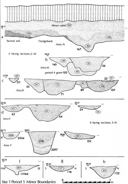
Figure 50. Minor Boundaries
All three of these ditches were subsequently cut by two ditches, 1K2458/1F904 to the north and 1D2010/1K2224/1F910 in the south, which defined a funnel shaped droveway focusing on what must have been a ford across the stream and opening out to the cast. The southern droveway ditch began in the centre of area 1D and then ran west-north-west for 32m into area 1F where a pronounced kink in its line resulted from its following the line of 1F906 for 2m before turning due west and extending nearly 20mtowards the stream channel. The northern ditch was both shorter and more substantial, starting 10m from the western limit of 1K and extending into area 1F where it followed a more gentle bend towards the southern ditch to form a 3m wide bottle-neck extending 5m towards the stream.
Major Boundary (Pls. VIA, and VIB, Figure 51)
At an early stage in this period the site was bisected by the cutting of a major landscape boundary, 1K3000, which in its first phase was constructed as a pit-alignment. This feature continued to function as a boundary, though probably of reduced status, until Period 7. Its east-west alignment was respected by field boundaries to the north in areas 1N, 1M, and 1R, by the trackway examined in area 1E and by an enclosure to its south in 1K. The continuity of this boundary, whilst important in itself, had led to constant recutting which had removed much of the evidence from the pit alignment; only in area 1F, where later recuts followed amore southerly course across the relict stream channel, did pits survive undamaged by subsequent ditch cuts. This boundary was excavated with box sections cut at 5m intervals along its line giving regular sections which quickly led to the identification of this primary element. The pits, which at the surface were square or sub-rectangular in plan, were up to 2m deep and 2-2.5m across, spaced regularly at intervals of 1-2m. Although the whole of this boundary could not be excavated there was no evidence to suggest any deliberate gap or gateway within the area examined. Both the scale of this boundary, which has been traced from the air running for several hundred metres to the west of the excavation, and the presence of similar alignments elsewhere in the project area, in Sherburn to the east and on the Wolds to the south, indicate more than a purely domestic land division.
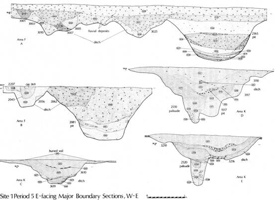
Figure 51. 1K3000 Sections.
On the eastern side of area 1K, where only the very lowest parts of each pit had survived later recuts, the pits had quickly filled with redeposited natural derived from the erosion of their sides. In area 1F, where three pits and the greater part of a fourth had survived later recuts, amore gradual sequence of filling could be identified. The primary silts in these pits were shallower than those found further to the east on account of the more compact nature of the natural silty sands and gravel through which they had been cut. There was no evidence that the pits had ever contained posts, nor had they been deliberately backfilled as one would expect if they had been dug to take bushes for a hedge. There was no indication that during this primary phase the pits had been cleaned out; rather they had been left exposed to the elements to stabilize when filled to a depth of c. 0.5m. That the relict stream channel had continued to flow throughout this period could be demonstrated by the presence of clays derived from flooding in the fills of the pits and later ditches: however, during this period the stream must have followed a channel further to the west than those examined in the excavated area. That flooding may have been more extensive to the west, is implied by the change in alignment of later phases of this boundary, traced on the adjacent Site 10 from the air. During this stage flooding appears more localized than that affecting later phases of the monument, only affecting the three pits nearest to the stream channel.
Given the scale of these features individually and as a group, it is clear that a large amount of spoil must have been produced during their initial excavation; no clear evidence of any associated banks could however be isolated.
In its second phase the pit alignment was cut through at the eastern end by a 2m deep narrow slot, 1K2503, of which only the lower 0.4-0.5m survived later recuts. This slot, the base of which measured c. 0.3m across, had vertical sides and may have served a function as a palisade slot. No evidence of individual timbers could be isolated; however, in a number of sections, the fill of the slot was divided between a sandy and a more gravelly matrix along a vertical line perhaps indicating the presence of timbering. The slot ran for 30m before terminating at a well-defined butt end. To the south a shallow ditch or gully 1K2038 may have been contemporary; it was parallel with the slot and terminated at a roughly parallel position. No evidence survived to indicate whether the line of the slot had been continued to the west either by the cutting of a ditch or by cleaning of the pit alignment which, by this stage, had already been largely filled. Had the slot contained timbering its function must have been to restrict the movement of stock rather than defensive, given the lack of any other linked elements of a similar scale. A group of post-holes, aligned at a right-angle between the slot and the parallel ditch, may indicate the presence of an associated fence and gateway; it is unfortunate that the area to the cast, which may have contained the evidence required to explain the function of these features, was destroyed during earlier quarrying.
Both to the north and south of the pit-alignment extensive deposits of buried soils survived, protected from modern agriculture by a deposit of aeolian sand, which at its greatest was over a meter thick. To the north the limit of these relict soils was well defined by an east-west ditch, 1N905/M907/1R910, (PL. VIIA) which also defined the northern limit of occupation during this period. In the eastern part of area 1N the distinction between the soils to the north and south of this boundary was at its greatest. In contrast to the almost black soils to its south, those to the north, whilst still darker than the sealing layer of wind-blown sand, were a dark brown in colour; most importantly they were associated with ploughmarks, the primary series of which clearly respected the line of the ditch.
Immediately to the south of the ditch cut, a metre wide strip of thin buried soil may indicate the presence of a hedge bank on this side; certainly any such bank could not have lain to the north where ploughmarks ran right up to the lip of the ditch. No ploughmarks could be detected to the south of this ditch. In its second phase this ditch, which cut across the southern side of barrow 1M and the Period 4 stream channel in 1R, turned in the centre of area 1N to run due north for nearly 10m before butting out.
To the south of the pit-alignment at its eastern end a shallow enclosure ditch, 1K2072, which may be contemporary with the first ditched phase of the major boundary, entered the site from the cast extending for 20m parallel to and at a distance of 4m from the major boundary, before turning through a right-angle and running a further 20m in a southerly direction. As with 1K2038, through which it was cut, the cast-west portion appeared to define a narrow track or pathway against the southern edge of the principal boundary 1K3000.
The southern limit of activity during this period is less well defined than that to the north on account of the fact that a large area between areas 1A and 1C had already been quarried away prior to the present excavations. Area 1C, the central portion of 1D and much of area 1B had been truncated by quarry activity and it is not possible to ascertain how large a percentage of the archaeology had been destroyed. Had there been any major cast-west ditch system, however, the base at least would probably have survived; none was found. Excavation of Trackway 1 in area 1E and the examination of both the trackway and a possible floor layer to its south in two excavation rubbish pits on Site 9, 40m to the west, indicates that the occupation area was much more extensive than it originally appeared.
Trackway 1(PI. VIIB, Figure 52)
This trackway, which like the later trackways to the north had formed a hollow way defining its centre, was delimited by a small U-shaped ditch to the north and a second much slighter gully to the south. Entering area 1E from Site B to the west, where it was buried by a greater depth of aeolian sands, this feature, measuring 7.5m across, was demonstrable on the basis of a complex sequence of wheel-ruts both cutting and filled by a compacted layer of aeolian material. Since the upper layers had been truncated prior to the start of the excavation, the active life of this feature cannot be securely dated; pottery (Figure 53) in the northern boundary ditch, however, clearly demonstrates that in its first phase it can be assigned to this period.
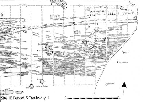
Figure 52.
Trackway 1.
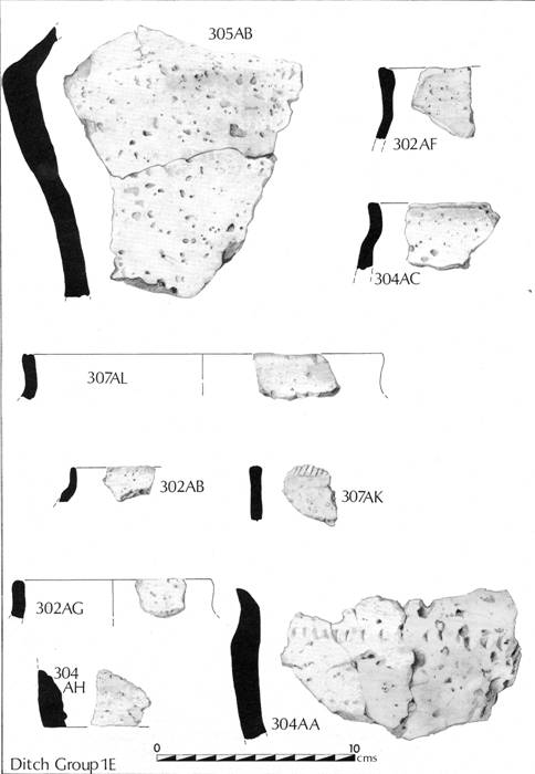
Figure 53. Pottery Group: Ditch 1E
A feature of the wheel-ruts was both the narrowness of the individual ruts coupled with what was frequently a V-shaped profile. If the wheels were very narrow and the sand was soft when they formed, the nature of the individual ruts can be easily explained as indicating intensive use by narrow wheeled vehicles during a period of aeolian deposition interspersed with wet conditions. It was difficult to isolate matched pairs of ruts since they were so tightly packed; where they could be a wheel separation of 1-1.5m was demonstrable. Only 25m of the trackway was available for examination but this was sufficient to determine its east-west alignment, parallel with the major boundary 1K3000 to the north.
Structures
The area bounded to the north by field boundary 1N905/1M907/1R910 and by Trackway 1 to the south contained a wealth of structural evidence, particularly throughout area 1K; the majority of structural features can be assigned to this period. Structural evidence was almost entirely restricted to post-holes. The dispersed nature of the evidence coupled with the rarity of stratigraphic relationships makes the phasing particularly difficult. The evidence has been subdivided into two groups of structures based on the degree of certainty in the interpretation; those structures which were clear during excavation are considered least suspect; the remainder were identified during post excavation. The two structural types most common throughout the lowland Iron Age, round houses and four post type structures, are both present in quantity. All are defined by a number prefixed with and ST as illustrated on the interpretation plan.
Circular/Sub-circular structures
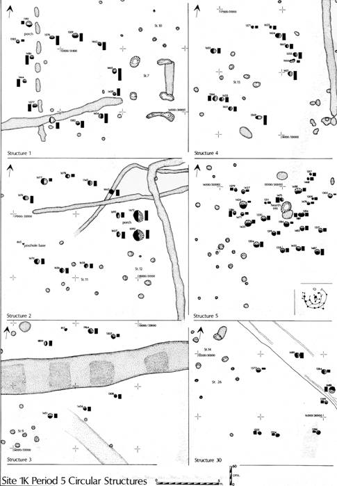
Figure 54. Circular and sub-circular structures.
Structure 1 (PI. VIIIA)
Contexts 1K1444, 1K1577, 1K1582, 1K1454, 1K1459, 1K1465, 1K1462, 1K1309, 1K1576, 1KI486
A round house, located 8 m to the south of the pit alignment near the western edge of area 1K, 7m across, represented by a single ring of ten post-holes evenly spaced at 2m intervals; they varied in depth from 0.21 m to 0.38m. No post pipes survived, but the size of the post-holes, which were all ovate in plan, suggest that they contained posts varying in size from 0.24m to 0.35m across. Two further post-holes 1K1190 and 1K1583 located to the north-west of the ring may indicate a porch.
Structure 2
Contexts 1K1140, 1K1678, 1K1677, 1K1676, 1K665, 1K1670,1K1656, 1K1658,1K1607,
1K1695, 1K1090, 1K1672 and possibly also 1K1663
A well-defined round house, was located 5m to the south of the pit alignment in the eastern half of 1K. A porch facing east was represented by two large post-holes situated just over a metre to the east of the ring. The post-holes were broader but shallower than those in Structure 1. If the structure was at all symmetrical then two post-holes were missing on the western side; this is not unlikely since the western part was within one of the strips cut to natural in the initial sampling of this area. Context 1K665, a concentration of pottery in a shallow scoop in the natural, may have been all that survived of a post-hole. The relationship between this structure and enclosure ditch 1K2072 suggests it was not contemporaneous, the pottery indicating that it post-dates this structure.
Structure 3
Contexts 1K1809, 1K817, 1K1964, 1K1307, 1K145I, 1K1456, 1K1308
The structure was represented by an arc of four post-holes to the north and another of three to the south of the pit alignment. The post-holes are uniform with the exception of 1K1817 which was very small. These two arcs indicate a structure measuring c. 7.5-8m in diameter, pre-dating the pit alignment; thus belonging to the earliest phase of Period 5.
Structure 4
Contexts 1K1667, 1KI255, 1K1601, 1Kl624, 1K1625?, 1K1571, 1K1653, 1KI266, 1K1651, 1K1569, 1K1666
A group of post-holes to the west of the enclosure ditch 1K2072, at its southern end, may indicate the presence of a further round house of similar scale to those above. The post-holes were shallow, 15-28cm in depth, but uniform in scale. 1K1666, 1K1571, and 1K1625 were all smaller and may represent associated stakes. This is the least convincing of the circular structures defined.
Structure 5
Contexts 1K1426, 1K1471, 1K1425, 1K1204, 1K1218, 1K'455, 1K1487, 1K1217, 1K1468 1K1317, 1K1428, 1K1427, 1K13N, 1K1220, 1K1219, 1K1482, 1K1476, 1K1488, 1K1475, 1K1184, 1K1189, 1K1394, 1K1195, 1K1447
This group of features, located between the droveway ditches in the western half of 1K, belongs to a different class of structures from Structures 1-4; not only was it smaller, with a diameter of just under 7m, but it also appeared to have incorporated two concentric rings of posts centred on a hearth indicated by an ovate patch of sand burnt to a depth of 25cm. Two post-holes, 1K1386 and 1K1579 may indicate that this structure had a porch facing the west.
Structure 30
Contexts 1K1377, 1K1689, 1K1284, 1K1688, 1K1399, 1K1396, 1K1324, 1K1323
Located south of the main boundary between Structures 1 and 2 and composed of eight shallow post-holes, the structure appears to have suffered badly from erosion, especially on the western side: towards the east, the average depth of the post-holes increases from 5cm to 18cm. Four-post structures 14 and 26 immediately to the north-west may be associated.
Structure 6 Area 1KH House (PL.VIIIB, Figure 55)
In response to the discovery of an unusually dense scatter of pottery, an associated oven base or hearth, and a dense distribution of post-holes, the north-western corner of area 1K, at the northern limit of the occupation zone, was subdivided. Area 1KH, covering less than 300 sq.m, produced the highest density of Period 5 ceramics of any part of the site. Not only was the quantity of ceramic material higher than that encountered elsewhere but it also includes material from both of the ceramic phases with parallels from both Scarborough and Staple Howe. The very fragmentary nature of this material is in keeping with the interpretation that the exposed old ground surfaces in this area included floor layers or at least unabraded occupation surfaces. The high density of the post-holes may imply either that the principal structure, centred just to the cast of the oven 1K1881, was completely rebuilt at some stage, or more likely that the wall line on the eastern side was rebuilt or reinforced by the addition of further posts. Whichever is the case, the structure had a longer life than the others present on the site. The pottery shows a marked concentration on the eastern side where there is some indication of a porch.
Only in the case of this structure and Structure 1 can rubbish pits be directly related. It must be significant, however, that since the ceramics derived from the immediate area of this structure span a period in excess of 200 years, the quantity of occupation debris is minimal. The size of the post-holes in this structure were generally more substantial than elsewhere, and whilst there are clearly a number of constructional phases, the ceramic evidence prevents their detailed interpretation.
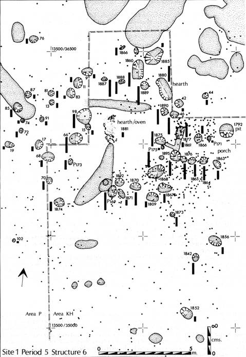
Figure 55. Area KH and finds distributions
Sub-rectangular structures (Figure 56)
More than 20 small sub-rectangular post-hole settings indicate the presence of a number of four-post structures. Frequently the pattern has been extended to incorporate more than the basic four posts. As with the circular structures identified above, the following structures include both those which can be ascribed with a high degree of certainty and a number which emerged only after examination of the evidence during post excavation. In view of the density of post-holes within the occupation area, it is likely that several more structures remain to be discovered; it is likely, in some areas, that the posthole distributions would be responsive to the type of pattern recognition programs developed by Gary Lock for Danebury (Cunliffe 1984).
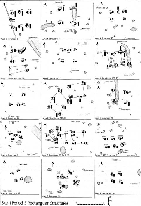
Figure 56. Sub-rectangular structures
Structure 7
Post-holes 1K1163, 1K11193, 1K1434, 1K1433
Slots 1K1390, 1K1393
The largest of the four-post structures examined, Structure 7 measured 3m square and was situated immediately to the cast of the round-house Structure 1, respecting the terminal of the southern droveway ditch 1K2224. Of the four massive post-holes two on the eastern side, where the post-holes were linked by a shallow slot, had been recut. To the south a deep curved slot may have been associated, perhaps providing anchorage for a ladder. The scale of the post-holes indicates that this structure must have been substantial.
Structure 8
Post-holes 1K1176, 1K1199, 1K1225, 1K1683, 1K1684, 1K1685, 1K1686
A large rectangular structure, measuring 3 by 3.5m,located centrally between the two round houses Structure 1 and 2. It was defined by six principal post-holes, forming the two sides with a seventh shallow post-hole placed centrally at the western end. From the postholes, it is clear that the structure was built out of massive posts up to 0.45m across.
Structure 9
Post-holes 1KI262, 1K1361, 1K1376, 1K1448, 1K1392
Defined by a rectangle of four post-holes and enclosing an area measuring 2 by 1 m, with a fifth posthole in the centre. The post-holes, though uniform in size, were all very shallow, being not more than 0.15m in depth. This was the only structure of this type discovered.
Structure 10
Post-holes 1KI453, 1KI489, 1K1363, 1KI452, 1KI449
A rectangular structure, measuring 2. 5 by 2m, located between Structures 7 and 9, was indicated by three very shallow (5cm deep, and two deeper, 15cm deep) post-holes.
Structure 11
Post-holes 1K1657, 1Kn674, 1KI267, 1K135I
Four shallow post-holes, measuring 8-12cm in depth, enclosing an area 2m square and cutting across the southern side of Structure 2, demonstrate the presence of this structure.
Structure 12
Post-holes 1K1253, 1K1605, 1K1671, 1K1603, 1K1602
Located 2m to the east of Structure 11 and to the south of the porch of Structure 2, these five posts indicate a structure measuring 2m square. In contrast to Structure 11 the corner post-holes were quite substantial, cut to a depth of 0.26-0.29m. The small post-hole 1K1671 on the northern side of the structure may indicate the presence of a ladder.
Structure 13
Post-holes 1K1762, 1K1033, 1K1095, 1K1764
This 2 m square setting was located within the area defined by the enclosure ditch 1K2072; a small curving slot on its eastern side was probably associated. The post-holes suggest that it was constructed from timbers measuring 0.25-0.4 m across.
Structure 14
Post-holes 1K1180, 1K1322, 1K1179, 1K1395
A four-post structure, measuring 2m square and located to the east of Structure 5. The post-holes, though uniform in scale on plan, varied in depth between 7 and 21cm. A second group of four post-holes, 1K1177, 1K1178, 1K1185, 1K1186, define a 3 by 1m area, were all very shallow but may define a related structure.
Structure 15
Post-holes 1K1102, 1K1572, 1K1570, 1K1103, 1K1618
This possible structure located within the area enclosed by the post-holes of Structure 4 measured 2.25 by 1.25 m. The three post-holes which defined the north-eastern side were both larger and deeper than the two that defined the opposite side.
Structure 16
Post-holes 1K1070, 1K1405, 1K1406, 1K1770
Structure 17
Post-holes 1K1413, 1K15S1, 1K1568, 1K1061
Structure 18
Post-holes 1K1373, 1K1374, 1K1565, 1K1554
A large number of post-holes around the southern end and to the cast of the enclosure ditch 1K2072 indicate the presence of a sequence of four post structures in this area. To the east a shallow gully which cut the buried soil 1K400 but did not cut into the natural beneath may represent an associated drip gully. The post-holes at the eastern endof the group showed evidence of recurring and the most acceptable interpretation is that here a series of four post structures had been constructed over a long period of time. The post-holes of the latest structure not only cut through the buried soils but also appeared to cut through the western lip of the gully. Following this interpretation, at least three four post structures measuring just over 2m square can be defined.
Structure 19
Post-holes 1K1535, 1K1534, 1K1359, 1K536
In addition, a number of possible four post type structures have been identified. The groups are listed below, their dimensions listed in the microfiche (M2/53-56)
Structure 20
Post-holes 1K1511, 1K1512, 1K1508, 1K1510
Structure 21
Post-holes 1K1829, 1K1822, 1K1728, 1K172I, 1Kl7I4
Structure 22
Post-holes 1K1320, 1K1743, 1K1811, 1K1210, 1K1812, 1K1727, 1KI294
Structure 23
Post-holes 1K1845, 1K1832, 1K1847, 1K1833
Structure 24
Post-holes 1K1838, 1K1839, 1K1834, 1K1846
Structure 25
Post-holes 1K1780, 1K17S1, 1K1771, 1K1773
Structure 26
Post-holes 1F
A dense scatter of post-holes at the eastern end of area 1D and extending into 1C to the south are less easily interpreted. A large number had been recut indicating that the area had been the setting for structures which were replaced over a long period of time.
Note: The data for Period 5 structures is available on M2/53-56.
The Pits (Figure 57)
Only ten pits contained appreciable amounts of ceramic material, and even these assemblages were limited. The pits were all small, less than 1.5m across and less than 0.4m deep, suggesting that their function as rubbish pits may well have been secondary; however, there was no indication of what their primary function may have been. As an indication of the extent of occupation the pits offer little, but given the very shallow nature of those excavated in areas 1F and 1K, more may have been entirely removed in areas 1C and 1D prior to the start of excavation.
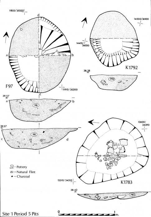
Figure 57.
Period 5 pits.
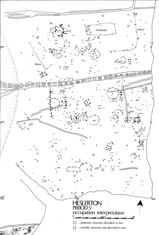
Figure 58. Period 5 Occupation Interpretation.
THE LATER PREHISTORIC AND ROMAN POTTERY by Val Rigby (see M2/57-70)
Introduction
Despite the discovery of two vessels which were substantially complete at the time of deposition, most contexts produced plain body sherds less than 20 by 20mm. Almost all of the prehistoric, and much of the Roman pottery examined, consisted of sherds of handmade fabrics tempered with such soluble grits that they had been entirely leached out by the action of acid ground water, leaving a friable and vesicular clay matrix. Such a combination of sherd type, size, and condition severely limits the information to be recovered from the pottery.
Method of recording
All sherds from all contexts have been classified and the average condition of each group estimated using a 6-point scale:
A: all sherds from a pot
B: complete profiles
C: several sherds from the same pots
D: sherds over 40 X 40 mm
E: sherds between 40 X 40 mm and 20 X 20 MM
F: sherds less than 20 X 20 MM
Where possible, sherds have been classified by both form and fabric; however, plain body sherds could be classified only by fabric. All rims and bases have been recorded, with an estimate of the amount of circuit surviving. Where appropriate, attempts have been made to work out the number of pots represented in a context, using various criteria. At all stages, despite the limitations imposed by the condition of the material, sherds have been checked for joining sherds within and between contexts. This information is recorded in the manuscript archive.
The condition of the sherds
From over 500 contexts examined, only 20 produced later prehistoric sherds greater than condition F, i.e. 20 by 20mm. They are seven ditches; 1C635, 1K38, 1K72, and 1K458, and the east-west ditches in areas 1E (299/307) and 1T, and the middle north-south ditch in area 1X (62); ten pits; 1F6, 1F98, 1K133, 1K502, 1K712, 1K783, 1K792, 1K827, and 1K876; one post-hole; 1C430 and the plough mark 1F319/20. The largest sherds and hence the "best" groups concentrate in the adjacent areas 1F and 1K, and may indicate that this was a nucleus of later prehistoric occupation, or that the area has not suffered such severe damage.
The quality of these "best" groups is still very variable, for example, the pit 1F98 and the ditch 1K72 each included a pot which must have been complete, or substantially complete, at the time of deposition, while the remaining pots are represented by anything from 1 to over 20 sherds, some looking more worn and residual than others. In contrast, the Pit 1F6 and the post-hole 1C430 contain groups of no more than three sherds from a single vessel, subsequently further fragmented. Since 1F6 includes rim sherds, the vessel can be classified, but since only body sherds were recovered from 1C430, the form cannot be classified or dated.
The remaining features produced only small, plain body sherds with so few joins that practically every sherd appears to form a different pot. It is clear that such sherds had enjoyed a long and varied history of disturbance and redeposition between the initial discard of the original vessels, and the final deposition of individual sherds into the contexts from which they were excavated.
Most sherds from the layers interpreted as windblown and buried soils were also small and worn, differing little in size and degree of weathering from sherds found in the majority of defined features. The most notable exception are those sherds recovered from the "buried soils" of area 1F which are even more abraded and markedly water-worn, suggesting that they were deposited by the stream during floods.
The small size and light weight of all F condition sherds is such that, even if they are typologically datable, they cannot provide reliable dating evidence for the feature of layer in which they were found. It is all too easy for such sherds to be intruded to considerable depths into both earlier and later features by the simple processes of consolidation and subsidence of the filling, as well as worm action and the activity of small mammals.
Quantification and estimated vessel counts
The small size and vesicular condition of most sherds rendered weighing an unsatisfactory method of quantification. A simple sherd count was used, coupled with various attempts to estimate the actual number of vessels represented in the 'best' groups.
The 'best' groups produced only four rim and base associations in the form of two 'complete' pots and two rim to base profiles; in addition, there were 56 rims and 18 bases representing different vessels. The equivalent totals for the site as a whole are just 70 rims and 37 bases, emphasizing that the "best" groups produced the bulk of the significant pottery (see Table 1M2/68).
Both counts show an interesting imbalance of rim and base totals. One contributory factor must be the difficulty of identifying small base sherds from large handmade pots when no wall edge survives. However, even if the base totals are doubled to allow for this problem, there is still a marked deficit. Furthermore, when the individual rims and bases in the 'best' groups were checked, they proved to be from different vessels, implying that a lot of mixing and disturbance had taken place before final deposition.
The composition of the pit group 1F98 suggests that actual selection may have taken place after the initial breakage of a pot, and on subsequent occasions also. Judging from the condition and size of the sherds, it was probably a rubbish deposit, not an accretion of accidentally silted sherds. The most complete vessel, no. 7 (AK), was substantially intact at the time of its discard, so that 1F98 can be considered as its initial place of discard. There is a complete rim and body circuit, but the lower body is so very friable and the inside surface so abraded that no base sherds could be identified; it may be that the uncertain state of its base was the cause of its discard. The second most complete vessel, no. 8 (AE), is represented by a complete profile from rim to base; however, the rim and base do not join, because they are from opposite sides of the pot. The initial place of discard of this pot presumably lay elsewhere, and was followed by sufficient disturbance for six sherds from opposite sides to be deposited together. The existing rim and base sherds, and possibly the missing ones too, are of a size and shape to have made useful scoops or spoons.
No body or rim sherds could be identified for the largest surviving base in the group, no. 9 (AL), which survives as about half the base circuit, with no wall edge. It appears to have been trimmed in antiquity to produce a flat lid or platter which subsequently broke into two or more pieces. The remaining sherds in the group enjoyed a much longer and more incident prone history than nos. 7 (AK) and 8 (AE), but show no signs of re-use, like no. 9 (AL).
Using rim count alone eight vessels are represented in 1F98, but only four by base count. When the sherds were sorted according to likely vessels, a total of 20 was achieved, which exceeds the added rim and base totals. If the combined total of rims and bases under-represents the actual minimum number of vessels so greatly, the same is likely to be true for the site as a whole.
The Fabrics
Where identifiable, the wheel-thrown Roman wares consist of typical products of the local Norton, Throlam, and Crambeck potteries, which developed into important regional production centres in the late third and fourth centuries. The earliest Roman ware are three small and worn samian sherds, one each from South, Central and East Gaul, and dated from the late first to the early third century. There is a body sherd from a lattice decorated jar in grey sand-tempered ware which is more likely to date to the second rather than to the third century, but otherwise, few if any wheel-thrown or handmade vessels pre-date AD 270.
Three basic fabrics have been identified amongst the handmade sherds, they are:
(a) vesicular or corky wares, where little or none of the original tempering survives
(b) flint tempered
(c) rock or erratic tempered wares
Matt black inclusions can be seen in some of the light coloured clay matrices. They are chopped organic and vegetable matter, or crushed fired clay (grog) or naturally occurring clay pellets. Because it is difficult in the hand specimen to see and distinguish between them, they have not been used as criteria in the fabric types.
Vesicular wares account for over 95 per cent of the total of handmade sherds. In a few examples some crushed crystalline calcite and matt chalk fragments survive and together, they are the most likely candidates for the original main tempering agents. A few shell-tempered sherds occur amongst the mass of calcitic fabrics found at Staple Howe so an element of doubt remains.
The vesicular fabrics have been subdivided according to void size; those with an average range of void-size less than 2 mm are classed as 'fine wares', while those averaging over 2 mm are 'coarse'. There is a certain relationship between wall-thickness, surface finish, and void or temper size. Predictably, smaller and more thin-walled vessels, with well-smoothed and glossy burnished finishes, are 'fine wares', with more carefully selected and smaller inclusions than larger and thicker-walled vessels. Some bases showed the effect of rough-casting on the underside of the base, where they had been stood to dry on a surface of loose grits, before firing.
With the exception of twenty-eight sherds, all vessels from the "best" groups are in vesicular fabrics, both coarse and fine versions. Typological evidence from Staple Howe and Castle Hill, Scarborough, suggests that calcitic tempering was introduced as early as the ninth century BC, while evidence from later sites in the region show that it continued in use until the end of the Roman period. In a few cases, it has been possible to isolate some Roman vesicular wares due to a combination of colour, sandy textured matrix, and surface finish; however, most groups of small, plain body sherds remain undated.
Flint tempered wares (FTW) are scarce, with a total of eighty-three sherds. Generally, the calcined flint is rather cube-like in shape, and fairly coarse, over 2mm in length, and is set in a fine-grained clay matrix. Most of the unclassifiable plain body sherd should be of late Bronze Age date, but some could be Neolithic. Their contexts are concentrated in the adjacent areas of 1F, 1KH, 1K, and 1M, the most significant being the post-holes of area 1K and the so-called 'floor layers' of area 1KH. It is there that one of the few rim sherds in FTW, decorated with finger-tip impressions along the top edge of the rim, occurs below some fragmentary examples of the plain and shapeless typological phase (Phase SP), and so provides the only relative stratigraphy on the site for the two phases.
Erratic tempered wares are even scarcer than flint, with a total of thirty-four sherds, only one of which is a diagnostic rim sherd (no. 10, 1F98AA). Thin-section analysis of sherds from other sites in the region, in particular the Burton Fleming Cemetery and the Rudston Villa, has shown that the rock fragments comprise a wide variety of crushed basalt, granite and mica schist used individually and together. There are no outcrops of such rocks in the region of the Yorkshire Wolds. The nearest geological source of basalt is the Great Whin Sill, and its associated dykes which occur in the Cleveland Hills and the North Yorkshire Moors, about 50km to the north. The nearest sources of granite are Shap Fell and the Lake District of Cumbria, the Cheviots in Northumberland and, more generally, Scotland and Scandinavia.
These rock-tempered wares are not therefore obviously local to the region. They could have been introduced as complete pots as a result of trade or exchange, or of population movement, which could have varied from nomadism and transhumance to migration or even immigration. However, no single source area has granite and basalt in close proximity, and this is necessary because there are examples with mixed tempering amongst the pots from Burton Fleming. Moreover, a number of different types of basalt and granite are present and no single source area could provide the full ranges to satisfy all of the different temper associations identified. If rock tempered wares reached the area through the movement of pottery or population, or even both, then a very complex interaction must have taken place, with the pottery originating in a number of widely scattered regions, including Scandinavia.
A much simpler explanation is that these exotic rock fragments were originally erratic boulders, introduced from Scotland and Scandinavia during the final glaciation of the region, and deposited in the glacial drift when the ice retreated. Research into the glacial erratics of northern and eastern Yorkshire shows that all of the varied types of basalt and granite are present in the glacial drift. Prehistoric potters could have collected boulders and pebbles from superficial secondary sources like plough-soils, stream beds and coastal beaches, while many would have been recovered from potting clays as they were being dug. The term Erratic Tempered Wares (ETW) is therefore preferred to Rock Tempered Wares, and is used throughout the discussion and the catalogue.
The dating of ETW may eventually depend upon its absence from Staple Howe, its scarcity at West Heslerton, less than 5 per cent in the features included in Tables 1 and 3 (M2/68, M2/70), and its abundance in the Iron Age cemetery at Burton Fleming (Excavated by I. M. Stead). At Burton Fleming, ETW is particularly associated with small, shapeless, and plain vessels, with lumpy, roughly finished surfaces. However, the situation is not entirely simple because there is a carinated jar of type 4B, no. 10 (1F98AA), in ETW, in the pit group 1F98, which shows that the ware was being made before the fourth century BC, the earliest date for the Burton Fleming cemetery. At Castle Hill, Scarborough, there is a varied range of forms in ETW which show that this type of tempering had a longer history, extending back into the Bronze Age, than at first appears at Staple Howe and Burton Fleming.
The Forms
A summary of the incidence of forms found in 15 of the 20 "best" groups is given in Table 2 (M2/69). It highlights two separate typological groupings or phases which occur in different features, the first comprising angular and decorated forms, Group AD, and the second, limited to rather shapeless and plain forms, Group SP. Because of their physical separation, the two phases may be of chronological or functional significance (i.e. indicating areas of different but contemporary activity requiring different types of pottery). Since the sample size is comparatively small, and the sherd condition poor and uninformative, it is possible that the effect is simply accidental.
The best and largest groups of Group AD pottery occur in the pits 1K783, 1F98, and 9B1, the hearth, 1K881, and the east-west ditch in area 1E (299-307). All sherds decorated with finger-nail impressions made directly into the body wall are in vesicular wares, with the exception of one rim sherd, with finger-tip impressions along the tip edge of the rim, which is in FTW. The bulk of the sherds in Group AD contexts are in vesicular fabrics, although FTW and ETW are represented, the most notable example being the carinated jar, no. 10 (1F98AA), which is typologically the earliest form in ETW to be identified at West Heslerton, Staple Howe, and the Burton Fleming Iron Age cemetery. There are a number of shapeless and plain forms present in Group AD groups, but they are rather different to those occurring in Group SP.
The basic forms and decoration of Group AD can be paralleled widely in southern Britain, but they occur in fabrics more or less heavily tempered with flint. Such assemblages have been assigned to the transitional period between the late Bronze and early Iron Ages, perhaps the eighth to sixth centuries BC (Barrett 1980, 297). There are regional and chronological differences in the kinds of temper used in which local geology is an important factor. In some areas, supplies of flint were easily available, and so it continued to be used for much of the first millennium BC Where naturally 'tempered' glauconitic and shelly Jurassic clays, and the sandy clays of the Triassic were accessible, they could and did increasingly replace flint towards the middle of the first millennium. When and where flint was rare or unobtainable, then alternative tempering agents had to be found.
At Staple Howe, Group AD forms occur almost exclusively in fabrics tempered with crushed crystalline calcite and chalk. There is, however, at least one decorated jar in shelly ware, so that it was presumably brought in from the region to the south, near the north bank of the Humber, where shelly clays outcrop. Vesicular fabrics are predominant in Group AD forms at Castle Hill, Scarborough, although they do also occur in FTW and ETW. It appears therefore that calcite and chalk were the main regional tempering agents for the Yorkshire Wolds and the Vale of Pickering, during typological Group AD.
Group SP forms occur in the area of the area 1K "round-house" (1K2007), the pit 1K792 and ditch 1K72. No convincing carinated or decorated forms of Group AD have been identified in these groups, despite the presence of shapeless and plain types in Group AD. The crucial difference between the phases is therefore the absence of Group AD types in Group SP, rather than the presence of shapeless and plain forms.
There are no obvious changes in the choice and preparation of the clays and tempering, for the fabrics are still vesicular. Two points are worth noting. First, the range of vessel sizes is increased, with a greater number of small vessels occurring in Group SP than in Group AD. Secondly, what slight vessel-shape there is, is mainly achieved by altering the wall-thickness - normally it is thickened at the shoulder, and less frequently at the rim edge, and it is slimmed-down at the neck or rim. Such changes alter the exterior shape of the vessel without greatly altering the shape of the interior, which is a rather wide-mouthed bucket-like shape. This technique was used on several pots in the Burton Fleming Iron Age cemetery which tends to support a date later than Group AD for Group SP; however, it was also used effectively to produce some of the most sharply carinated jars of Group AD e.g. no 1(1K783AA).
The area 1KH "floor layers" may have provided some relative dating evidence for the two phases, in the form of the Group AD decorated rim in FTW, discussed above. It was found below the Group SP groups, which implies that Group AD is the earlier. But, unfortunately, the sherds are small and worn, and in some areas there are definite Roman and Medieval sherds, so that little reliance can be placed upon the stratigraphy (Table 3). The presence of the Group SP types in the Burton Fleming and Danes Graves cemeteries, and of type 17A in ditches of the Rudston Villa, imply that these at least are at home in the periods succeeding Group AD, rather than preceding it.
Three vessels warrant separate consideration because of their apparently very close continental connections - they are the shallow conical bowl, Type 1, no. 37 (1F6AK and AN), and two rounded bowls or cups, Type 9C, no. 41 (1D10AL and 1K860AE). In their fabrics, they differ little from the bulk of the vesicular wares, although no. 41 (1D10AL) does include some fine flint inclusions. Therefore, there is no obvious reason to consider them as anything other than local products. They are all 'fine' burnished vessels; the conical bowl is particularly interesting for the most glossy finish is confined to the upper and visible surface, the lower, hidden surface having an altogether duller finish to it.
On the continent, these forms were introduced before the end of Hallstatt A, were most common in Hallstatt B, particularly in burials, and continued into early Hallstatt C. Since their protoypes were contemporary with at least part of the period of Group AD, it is unfortunate that none is helpfully stratified.
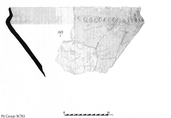
Figure 59.
Pottery from pit 1K783 (1)
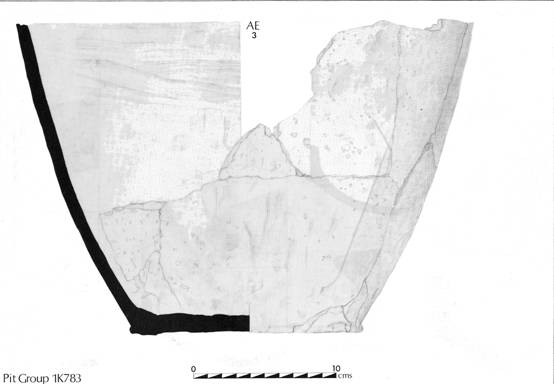
Figure 60.
Pottery from pit 1K783 (2)
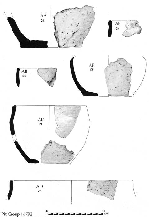
Figure 61.
Pottery from pit 1K792
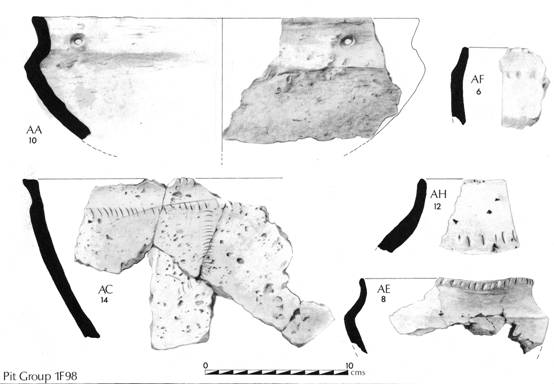
Figure 62.
Pottery from pit 1F98 (1)
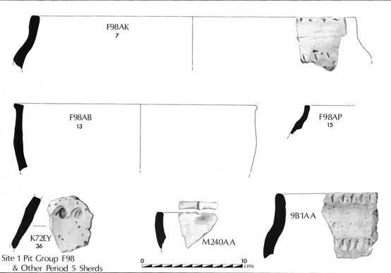
Figure 63.
Pottery from pit 1F98 (2) and Staple Howe Ware.
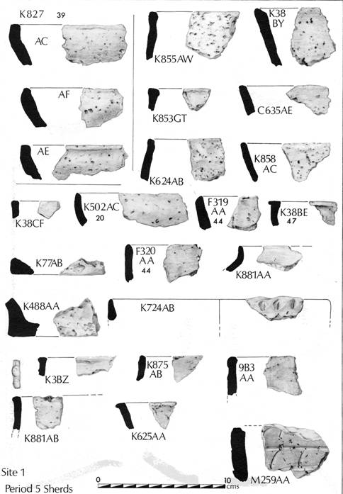
Figure 64. Iron
Age pottery (1).
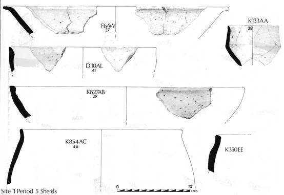
Figure 65. Iron
Age Pottery (2).
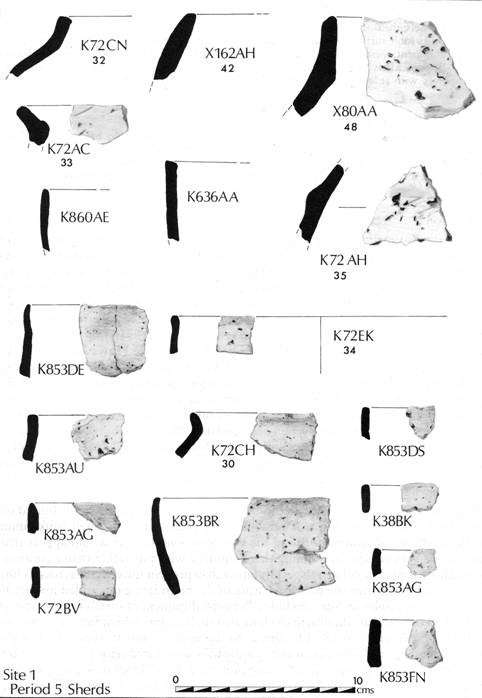
Figure 66. Iron
Age Pottery (3).
Conclusion
Despite its condition, the later prehistoric pottery from West Heslerton has contributed useful information in the study of ceramic developments in the region, in the first half of the first millennium BC. Two typological groups have been isolated which appear to be of chronological significance, and which assist in the fuller understanding of the large assemblage found at Staple Howe.
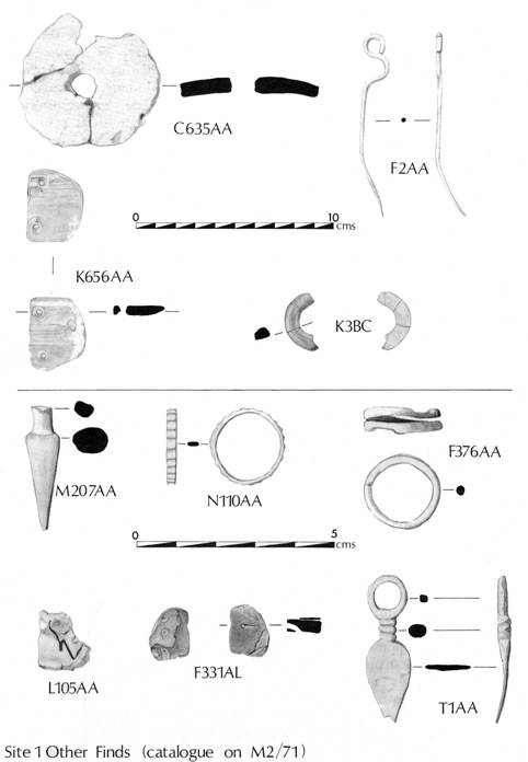
Figure 67. Other Artefacts.
DISCUSSION
The late Bronze/early Iron Age activity on Site 1 extends over an area of more than 1 hectare and although a number of major features and structures can be isolated, the overall interpretation is hampered by the small quantity of artefacts and the lack of any faunal material coupled with a lack of similar sites in northern England. Environmental evidence derived from the buried soils and aeolian layers above is confined to that from the soil, which was not conducive to the preservation of either pollen or seed remains. The principal importance of the occupation at this site lies in its setting within the wider landscape which includes the palisaded enclosures at Staple Howe and Devil's Hill, situated 1.2km to the south (Brewster 1966 and forthcoming). The pit-alignment, which appears to form a focus for the occupation, is clearly a landscape feature of considerable importance. It can be traced, from the air, extending more than 2 km to the west and, when connected with other segments within the project area can be shown to be part of a extended system of boundaries which may be used to demonstrate the presence of large, 800 hectare estates with Staple Howe and Devil's Hill as central places. The date at which the pit-alignment was constructed cannot be accurately ascertained on present evidence; however the pottery sequence and two Carbon I4 dates, may throw some light on this problem.
The land use pattern identified in the excavation and examination of the buried soils, indicates that the occupation area remained as pasture with a hedged bank running parallel to the pit-alignment forming the northern boundary. It would appear that in this case the very reason for defining this boundary with pits rather than a continuous ditched feature may have been to permit rather than prevent movement across its line; if this were to be true then the political nature of the boundary gains added importance. Two further examples on Site 1 include a Period 6 alignment of small circular pits to the north of area 1S, and an alignment of elongated shallow pits which form a boundary to the Period 7 cemetery in 1A. On Site 2, to the south, a fourth type which is more correctly termed a post-pit alignment appears to be associated with Period 7 features.
We are unable at present to fully interpret the role of Trackway 1 as part of this occupation area, since most of it and the area to the south had been quarried away prior to the excavation. The possible floor layers located to the south of the line of the trackway on Site 9 indicate that the occupation extends beyond the trackway to the south, further work in the areas to the west of the present site would produce important new results and must be contemplated if quarrying is to be extended into these areas. The complex series of wheel ruts in this trackway indicate that the trackway was used intensively by wheeled vehicles, probably over a long period; only further excavation can demonstrate the full date range of this activity. Its contemporaneity with the occupational sequence in its primary phase can be demonstrated from the pottery from the northern boundary gully 1E2299. The occupation evidence to the south of the trackway may indicate that far more was destroyed prior to the start of excavation than was originally thought.
The structural sequence and dating of the occupation area as a whole has to rely heavily on the interpretation of a very small artefact assemblage. This however does include material that can be closely paralleled at Scarborough, Staple Howe, and Devil's Hill (Brewster 1963 and forthcoming). Scarborough Castle Hill must certainly conceal a late Bronze/early Iron Age promontory fort beneath the Roman and medieval features for which the site is best known. Staple Howe, the principal type site for this period in the whole of the North, and Devil’s Hill, which closely parallels it, are both small palisaded enclosures which, whilst intensively occupied, can only have contained a very small population. The lack of excavated structures at Scarborough, which has produced a wealth of material from small pits, means that attention must be directed towards a comparison with Staple Howe in particular. The structural sequence at Site 1 includes both of the principal structure types found in the British Iron Age, namely round-houses and four-post type structures.
The most striking parallel is between the Staple Howe "granary" and Structure ST8 situated in the centre of 1K just to the south of the pit-alignment. This structure, whilst it displays similar overall dimensions, was based upon seven rather than the five posts of the Staple Howe example; given the difference in the subsoils on the two sites this fact is less significant than one might believe. "Post for post" comparison on sites with wildly differing subsoils is likely to prove of less value than the comparison of dimensions and overall scale. A second large four-post structure, ST7, is also comparable in scale; furthermore, on its eastern side the corner posts were linked by a shallow slot which shows a striking similarity with "water collector 1" recorded by Brewster. Structure 6 in area 1KH is likewise paralleled with "water collector 2" at Staple Howe. Given the sandy nature of the soils on Site 1 and the ready availability of water from the relict stream channel, this is unlikely to have been the function of these slots on Site 1. An examination of the plan of Staple Howe Hut II reveals that here "water container 1" may have been an integral part of a small five-post structure, which throws some doubt upon the interpretation of this structure as a whole. An examination of the rectangular structures at Site 1 reveals a number of different basic types based on variants of the four-post arrangement, amongst these a six-post arrangement in which the longer sides turn in slightly at one end (ST27) can be paralleled by two structures on the Howe which were incorporated in Brewster's Hut III.
The whole question of the function of the Site 1 structures is difficult on account of the lack of associated evidence; however the lack of hearths in general must suggest that the majority of the structures were not built for human habitation, or at least if they were it may have been occupation of a transitory nature. Only in 1KH Structure 6 did good evidence of an oven and a hearth survive with a related series of post-holes and domestic refuse. Again a comparison with Staple Howe is necessary; Brewster’s Hut II contained both an oven base and a hearth located three metres away within the postulated structure. At the centre of Structure 6 a natural gravel involution appeared to have formed the basis of a small oven measuring 1.25 by 0.75m; around this natural outcrop of gravel eroded and burnt chalk blocks had been packed and bonded with clay. This feature, which had been damaged by agricultural activity, was further disturbed during stripping of the site; enough however survived to identify it as the base of a small oven. Three metres away to the north-east a soil hearth was located which appeared to have been outside the main structure. Elsewhere a hearth was associated with the concentric rings of posts which define stricture ST5. Only in area 1C were further hearths located and in this case the surface of the site had been so severely truncated by quarrying operations prior to the start of excavation that their association with any of the post-holes would be purely speculative.
The structural evidence for Period 5 covers a broad timespan, which at its greatest would have extended from the ninth to fifth centuries BC, in which Rigby has identified two basic ceramic groups (AD, angular and decorated, and SP, shapeless and plain). Whilst the end of the occupation activity can be fairly securely dated to the fifth century its beginnings are difficult to isolate; certainly there is no apparent occupation during the Arras period so well known from the square ditched barrow cemeteries (Stead 1979). At its most limited, the activity must have extended over at least 200 years given the ceramic associations with Scarborough and Staple Howe and thus, although an extensive collection of structures are present, there need never have been more than a few active at any one time. There is some indication in area 1KH that here occupation occurred during both ceramic phases, though whether this represents continuous or intermittent activity we can not say from the surviving evidence. The unenclosed location, poor artefact selection, and limited frequency of artefacts in general indicated that the site is one of low status in comparison with Staple Howe. Only two bronze objects from this period were recovered, both swans-neck pins. The construction of the pit-alignment must demonstrate a highly stratified but fully integrated society, based on the two palisaded sites, and it is certain that further examples can be found in similar topographic locations elsewhere on the Wold scarp. Two alternative interpretations may be offered for the structural and occupational activity on Site 1; in both cases it would appear that occupation was short-lived and intermittent. One alternative is that the activity should be directly related to the occupancy of the palisaded enclosures on the Wold scarp to the south and that it represents part of a transhumance economy in which the structures served as temporary habitation sites for both people and stock at certain times of the year only, permanent occupation being located ill the high status settlements. This interpretation can be largely discounted since it implies a far lower population than might be expected, based on the energies required to build the pit alignment; moreover the palisaded sites are really too close to justify the settlement structures even if some sort of transhumance economy were being practised. In the light of recent work on the linear settlement recorded from the air to the north of Site 1, an alternative and more plausible interpretation can be offered. In the subsequent period settlement activity becomes focused on an east-west trackway following the 30m contour through the project area. Along the line of this trackway a series of overlapping settlement enclosures can be identified which indicate a considerable degree of lateral movement in the settlement development. If the occupation evidence at Site 1 is seen as a prototype for the linear settlement which developed during the later Iron Age, then we must consider the sample examined as part of an evolving linear settlement which is repeatedly deserted and reoccupied, perhaps in response to the effects of overgrazing. The precise relationship between this open settlement and the palisaded enclosures can only be postulated but, given the presence of the major boundaries, a socio-political relationship not unlike that between the medieval manor and village provides a suitable interpretation of the evidence at hand.
The excavation and interpretation of this area, building on the foundations laid by Brewster in his excavations at Staple Howe and Devil's Hill, has revealed a previously unknown element in the occupation and operation of the early Iron Age landscape and should be seen as the basis for more detailed problem-oriented research in the future.
PERIOD 6
The evidence indicates that during this period the site was in use as part of an agricultural landscape. The principal features examined included field and trackway boundary ditches and limited structural evidence indicating occupation concentrated in areas both to the east and west of Site 1. The continuity of the field boundaries established in Period 5, including the major boundary first established as a pit alignment, is confirmed by the presence of later recuts in all cases. A number of new boundaries were also established which indicated that Period 6 may be subdivided into two distinct phases.
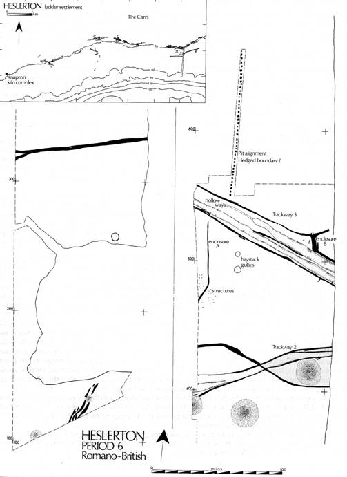
Figure 68. Period 6 plan.
TRACKWAYS
Two ditched trackways ran across the northern part of Site 1. The earliest, Trackway 2, cut across the
northern edge of Barrow 1R and ran in a east-north-easterly direction also cutting the northern side of
barrow 1L. The track was represented by a shallow depression varying from 5m to 10m in breadth. The trackway ditches showed evidence of having been recut, particularly in the eastern half of the site.
The southern trackway ditch was only excavated in areas 1L, 1R and partially in 1T. The northern ditch could not be isolated in area 1R, but the limits of the track were well defined by the fills of the track itself which contained a high clay element. In contrast to the other trackways examined no wheel ruts survived. The samples excavated contained a few finds; a bronze point and a piece of galena were recovered. The dating of the pottery suggests that this was the earlier and in use during the second and third centuries A. D. In comparison with Trackway 3 to the north, the "hollow way" that had formed between the two boundary ditches was shallow, no more than 0.2m deep.
Trackway 3, which traversed areas 1R, 1S, 1T, and 1X running north-west to south-east, was very much wider than Trackway 2 and possessed a much more pronounced "hollow way". For most of the part examined, the northern and southern trackway ditches were separated by a gap of 20m; in area 1X the northern ditch diverged in an easterly direction to meet another boundary before returning to join the general line of the trackway. On the western side of 1R a single hollow way was present covering the southern half of the trackway; by the eastern side of the site two very large hollow ways had formed. Wheel ruts were observed both in area 1R and in 1X, but in contrast to the complex series of layered wheel ruts identified in the Period 5 trackway in 1E, they were comparatively rare. A date in the third or fourth centuries A. D. is indicated both by the pottery and a single bronze coin (Victorinus, 268-70 A. D.) from the fill of the trackway in area 1X.
ASSOCIATED FEATURES (PLS. IXA and IXB)
Only one feature, a ditch 1T901/902, had a direct relationship with Trackway 2. The primary phase of this ditch entered 1R from the west, running directly east-west 25m to the north of the trackway, and then turned into 1S to run in a south-easterly direction, following an alignment parallel with Trackway 3, 80m further to north, before terminating with a well defined butt end against the northern ditch of the southern trackway. The fills of this well defined U-shaped ditch contained a similar clay element to the trackway fills.
Contemporary with, or pre-dating the trackway an enclosure had been defined by a small U-shaped ditch, 1R230/2004 (Enclosure A), which entered the site running in a north-easterly direction at the centre of 1R and then turned to run northwards for 50m before stopping 4m to the south of the trackway. A second ditch, almost entirely cut away by a later trackway ditch, entered the site from the north-west and ran 15m before turning sharply to the south and stopping just to the south of the trackway, leaving a 4m wide entrance into the enclosure. At the northern end of the enclosure, which in common with areas to the cast had been plough damaged, there was no evidence of occupation. At the south end post-holes demonstrated the presence of three four-post structures and a possible fence line. Two of the four-post structures were contained within the angle of the enclosure and seemed to respect its line, the third lay outside to the south-east; the fence line crossed the line of the enclosure ditch. Just over 20m to the cast of the enclosure two shallow ring gullies, 1S500 and 1S524, with diameters of 5m and 4m respectively, may have been drainage gullies around haystacks; their small size and the lack of domestic debris or other nearby structural remains argue against any structural function. A similar feature was found in area 1C, 1C454.
To the north of Trackway 3 a pit alignment, 1S924, extended 120m to the north before leaving the excavated area; at the southern end a gap of just over three metres between the pit alignment and the trackway may have been an entrance. This alignment was excavated in isolation. The pits, all of which were half-sectioned, were of fairly uniform size and shape and spaced at 2.5m intervals, measuring 1.5-2m in length, 0.8-1.2m in breadth and 0.5-0.75m in depth. They had not contained timbers but after the formation of rapid silt layers filling the lower halves, had stabilised and subsequently filled with aeolian deposits.
The change in the ditch alignments and frequency of recuts on the northern side of Trackway 3 in area 1X is difficult to interpret. A pair of post-holes, contained within the angle between the cast-west and north-south elements of the trackway ditch, one with an associated slot extending 1m to the south, may have been part of a structure aligned north-south, the southern part of which was entirely removed by the northern hollow way. A burnt pit just to the north of the cast-west ditch, and the relatively high distribution of pottery in the immediate area of the ditch junction, indicate a higher level of activity than was generally present in this part of the site. The double ditch 1X912/920 (Enclosure B), which ran north-east from the ditch junction, was earlier than the trackway ditch and it seems likely that the primary phase of activity in this area comprises three ditches which define the limits of a pre-trackway enclosure. A change in scale of the trackway ditch as it returns to follow the line of the track may indicate that the enclosure continued to function whilst the trackway was in use. To the south of Trackway 3 the ditch 1T902 which butted against Trackway 2 was recut, its line being extended (1M905) through the track and beyond before turning in an easterly direction, cutting across the southern edge of Barrow 1L; both the alignment and pottery contained within this ditch indicate that this phase was contemporary with the operation of Trackway 3.
At the southern end of Site 1 further Period 6 ditches may define a pathway running through areas 1A and 1HE in a north-easterly direction. The irregular shallow gullies spaced 2 m apart may alternatively derive from a loosely defined field boundary. The gap in ditch 1HE37 has been used to argue for the presence of a Period 4 barrow.
Late recuts in both the east-west ditch which, cut through the southern side of Barrow 1M, and the major boundary defined by the Period 5 pit alignment, indicate that these features continued to function as field boundaries throughout this period.
OCCUPATION
Examination of the pottery has identified further Period 6 material from areas 1K, 1D, and 1C. Period
6 pottery associated with the enclosure ditch 1K72, situated in the south-eastern quadrant of area 1K, where it defines two sides of an enclosure extending beyond the site may indicate that this feature should be assigned to Period 6.
PERIOD 7: ANGLIAN
Discussion of the Anglian evidence will be dealt with in later reports.
The Heslerton Project developed as a result of the discovery of Anglian
inhumations in 1977, when 35 graves were examined. A further 50 graves were examined
between l978 and 1981, and a further 40 in areas 2BA and 8AA during 1985. This
is the third inhumation cemetery in the North of England to be examined
extensively using modern techniques.
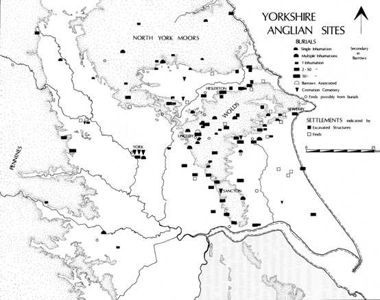
Figure 69. E. Yorkshire Anglian sites
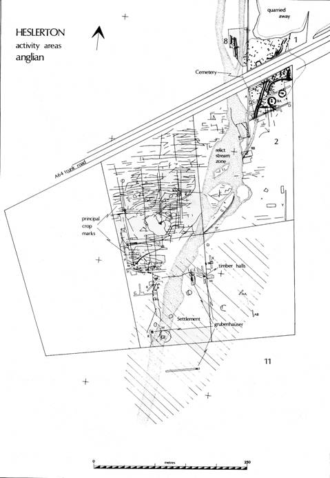
Figure 70. Period 7: cropmarks and activity areas.
THE CEMETERY
The cemetery (Figure 71), which originally covered c. 10000 sq.m, is divided by the A64 trunk road, and evidence recovered during the autumn/winter of 1985 indicates that whilst the northern and western boundaries have been fully defined, the limit on the eastern side is more complex than was originally thought. To the south the limit is marked by Barrow Cemetery 2, which provided the focus for the location of the Anglian Cemetery. In areas 1HE and 1A the eastern limit appeared to be defined by a pit alignment comprising shallow sub-rectangular pits, but recent excavation demonstrates that this is not necessarily the case since both inhumations and a number of plough damaged cremations beyond this line to the east may indicate that the cemetery has more than one focus.
To the north quarrying had already removed a large area before excavation began but since the northern limit of the grave distribution in 1B did not extend beyond the most northerly graves in 1HE, it seems likely that this boundary is firm.
From the evidence so far gathered, a number of differences between the two areas examined are apparent. Owing to a slight difference in the subsoils the level of bone preservation was considerably higher on Site 2 than on Site 1. On Site 1 the graves were dispersed; though a degree of grouping may be identified, there is no obvious indication of internal planning. By contrast, the areas so far examined on Site 2 indicated that the core of the cemetery lay here where the distribution was more compressed. A group of weapon graves, 2B64, 2B69, and 2B63, laid out in a row may indicate some deliberate planning. A second distinctive group in which the majority of the burials were of children was examined near the eastern limit of area 2BA during 1985.
The majority of the burials were accompanied, the grave groups including weapons, annular, cruciform and square-headed brooches, bead necklaces, pottery, and a number of less common object types. An important body of textile evidence survived in association with many of the metal objects; flax linen and woollen articles were both present. The summary report on the textile evidence has demonstrated the presence of tablet weaving, tabby, plain tabby, twill and diamond twill (Walton, pers. comm.). The cemetery group may be dated to the fifth, sixth and possibly early seventh centuries A. D.
Two graves deserve special mention; 1B103, (PL.XA) a horse burial, was clearly a ritual deposit in which a five-year-old mare was buried, the head having been removed and placed in the centre of the grave, the body then being laid around it with a bit between the legs. In area 2F the burial of a woman aligned west-east (2F13) had been disturbed by the burial of a male aligned north-south (2F12). The upper burial was accompanied by a bent spearhead, the lower burial by two annular brooches, a chip-carved cruciform brooch, sixty-two beads, and a number of bronze cylinders. These cylinders strongly resemble those reported by Mortimer from Driffield (1905, 281, Figure 802; 291, Figure 873); they had apparently contained small bundles of textile and may perhaps be interpreted as having functioned as lace ends on some elaborate piece of decorative clothing. A large amount of textile evidence survived beneath the brooches. On the reverse of the cruciform brooch a runic inscription, thought to spell out a personal name, had been scratched across the foot.
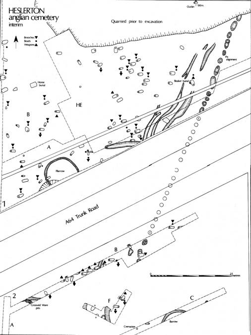
Figure 71. The Anglian Cemetery
SETTLEMENT
Sampling excavation on Sites 2 and 11 during 1982 examined a number of timber-framed and sunken-featured structures (Figure 72), the distribution of which suggests an occupation area of up to 1600 sq. m.
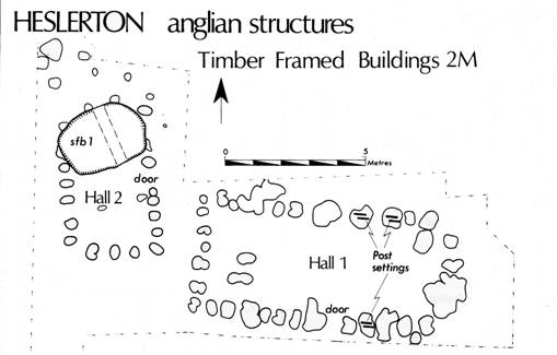
Figure 72.
Anglian Structures
Of the three sunken-featured buildings partially examined, two appear to have had cavity floors, the other a sunken floor. The fills contained large quantities of animal bone, unfired clay loom weights, and pottery. The small finds included fragments of single and double-sided bone combs, glassware, and a single bronze wrist clasp; Niedermendig lava and other imported stone types were also present.
Two structures were located in Trench 2M (PL. XB) The smaller, measuring 5.5 by 3m, was aligned north-south with a doorway to the cast. This structure had in part been cut by one of the sunken-featured buildings. The second, aligned east-west, with a central doorway to the north, measured 9 by 4m. This feature is closely paralleled by Hall 2 at West Stow (West, pers. comm.), although its construction from vertical planks has more in common with the structures found at Cowdery 's Down (Millett 1983).
FIELDS
Over 200m to the north of the cemetery a number of features indicated the
presence of fields. A shallow gully represents the last phase in the major
landscape boundary, first established in the late Bronze Age. A second ditch
40m to the north appears to be contemporary. These fragments indicate that the
Anglian fields, like those established in the prehistoric period, follow the
general east-west axis of the landscape.
FURTHER SETTLEMENT EVIDENCE: HESLERTON SITE 21
A small-scale research excavation undertaken at Sites 20 and 21 included the examination of two sunken-featured buildings associated with Anglian pottery including fragments of buckelurne, worked bone and weaving equipment.
CONCLUSIONS
The excavation at Heslerton Site 1 has shown that the Vale of Pickering was at least as intensively occupied from the later prehistoric period onwards as the two traditional centres of activity, the Yorkshire Wolds and the North York Moors. More importantly the Vale includes important and extensive deposits of aeolian material which have provided exceptionally well-preserved stratigraphy which is not susceptible to aerial photography or conventional surveys based upon fieldwalking.
The Mesolithic activity has provided some indication of what level of activity one might expect from dry land sites in the area. The light soils provided a setting for very early agriculture; however, the lack of artefacts and nature of the fills of a series of later Neolithic field gullies suggests that this activity was brief, and that at this stage extensive areas were available for arable cultivation so that large areas could be intensively worked and then abandoned in favour of other sites in the vicinity. The concentration of later Neolithic activity on the Wolds is clearly part of a much wider landscape, including other types of monument such as the avenue crossing Heslerton Site 1. The C14 date of HAR-6630 4060 ± 80 bp (2110 bc) from Barrow 1R implies that the relationship between Beakers, Food Vessels and the Peterborough/Fengate ceramic traditions may be more closely related than has been suggested; further dates will provide data which might help in the interpretation of the late Neolithic pits and the relationship between these three distinctive pottery styles.
The early Bronze Age landscape of the Vale includes the barrows and the flat cemeteries. The barrow mounds appear to be late developments which mark the final or penultimate stage in the development of these features which for a considerable period remained as flat cemeteries. The frequent multiple and disarticulated burials indicate a higher degree of continuity from the Neolithic than has been accepted in the past. The two partially excavated barrow cemeteries are in two discrete linear zones which extend beyond the limits of the excavations both to the east and west, demonstrating a structure to the landscape which indicates a valuable avenue for research. The topographical locations of these monuments and the scale of the final mounds argue against any Vocational model based on landscape dominance, and in favour of a distribution based on the economics of an intensively cultivated landscape in which areas of overworked and partially sterile soils provide a suitable setting for these long lived monuments. Certainly the examples excavated demonstrate contemporaneity and much longer life than has been generally accepted in the past. The two barrow cemeteries, when viewed in the light of crop mark sites to the east and west, belong to extensive linear zones of barrow construction, spaced 250 m apart and following the contours of the land. It is disappointing that, given the large scale of the excavations, no definite trace of occupation could be identified.
When the barrows went out of use, woodland regenerated coupled with an increase in aeolian soil movement which could perhaps be related either to the breaking in of new ground, probably to the north of Site 1, or complete overworking of shallow soils to produce a 'dustbowl' effect.
Soon after 1000 BC the site became the setting for extensive occupation activity, with the construction of a massive pit alignment boundary and a large number of timber-framed structures. This boundary continued in use until the Anglo-Saxon period, having been replaced by the construction of a palisade and then by a series of ditches. This feature can be linked to others similar in the wider landscape to suggest "estates" covering c. 800 hectares, centred and possibly maintained from the palisaded sites at Staple Howe and Devil's Hill. The late Bronze/early Iron Age occupation, probably ending c. 500-450 BC should be viewed as occasional occupation rather than permanent; arable fields lay to the north of the occupation area which was located on pasture to the north and south of the pit alignment. The occupation area was serviced by a trackway and might best be seen as the prototype for the linear settlement which ultimately succeeded it 500m further to the north. Limited crop and excavation evidence in this area suggests that there was considerable lateral movement of this settlement. An alternative would be to view the occupation area as part of a transhumance agricultural landscape; this seems the least plausible interpretation given the small scale of the local landscape. Amongst the circular structures of this date only one contained a hearth and some of the others may not have been for human habitation. A large number of four post-type structures were identified; a multitude of different structures could have been based on this simple post arrangement. The lack of pottery from Site 1 in comparison with the quantity and quality of material from Staple Howe suggests a low status site.
By 400 BC the site was again deserted in favour of the linear settlement to the north, which skirted the edge of a large expanse of fenland type environment in the centre of the Vale. An increase in intensity of land use to the south may have led to the extensive flooding which deposited clay silts in the major landscape boundary, which by this stage had reduced in scale to a small ditch with an associated bank.
During the fifth century AD an Anglian cemetery, possibly a double cemetery, was established based upon Barrow Cemetery 2 with an associated settlement 400m further to the south-east.
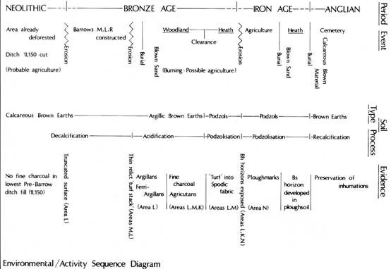
Figure 73.
Environmental and activity sequence diagram.
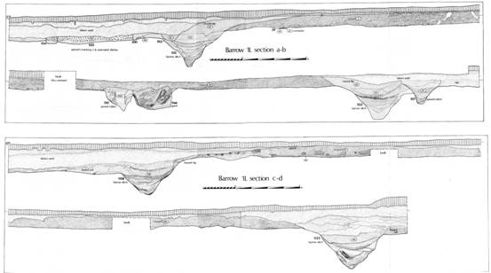
Figure 74.
Barrow 1L: fold out section.
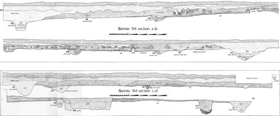
Figure 75.
Barrow 1M: fold out section.
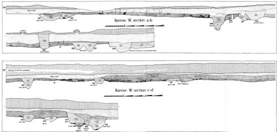
Figure 76. Barrow 1R: fold out section.
ACKNOWLEDGEMENTS
The nature of archaeological research is such that results can only be achieved through a team effort. This report represents the fruition of the labours of hundreds of individuals and a number of institutions working within a framework of limited time and resources.
Thanks are due first to Jim Carter who discovered the site and brought it to the attention of Mike Griffiths, the County Archaeologist, without whose determination and support the project could never have been completed. The HBMC (formerly the DOE), in particular Bill Startin, ensured that funds were available both for the excavation and the preparation of this report. Pre-excavation research and administrative assistance has been provided by the Archaeology Section of North Yorkshire County Council; special thanks are due to Paul Chadwick and Percival Turnbull. Their efforts would have been to no avail had it not been for the generosity of the landowners: E. Cook and Son (Site 1) and West Heslerton Farms (Site 2), who both granted permission for work to proceed and made every effort to ensure that adequate time was given for the excavation to continue.
The bulk of the work was undertaken by the volunteers and supervisors, too numerous to mention by name but to whom I am indebted. Tim Allen acted as assistant director until 1981 since when Christine Haughton has added this to the task of undertaking all the finds work.
Many of my colleagues both in the field and in universities have offered advice and assistance, in particular the specialists whose names appear in the text, the late T. C. M. Brewster who laid the foundations upon which this work has been built, Philip Rahtz, David Hill, Barry Jones, lan Kinnes, Terry Manby, and John Hurst. The drawings in this report were mostly prepared by John Hanson excepting the artefact illustrations which are by Glenys Boyles. The task of typing and editing the text has been undertaken by Christine Haughton throughout. This report could not have been brought to press as quickly without the assistance of Sharp Electronics (UK) who have donated computer hardware, software and support over the last three years.
This report could not have been written without the dedication of my associate authors Christine Haughton and John Hanson; thanks are also due to Ian Kinnes, Martin Millett, and Tim Schadla-Hall who read the manuscript and offered helpful comments and suggestions. The responsibility for errors, whether of fact, omission or interpretation must, however, remain my own.
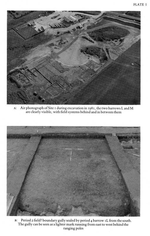
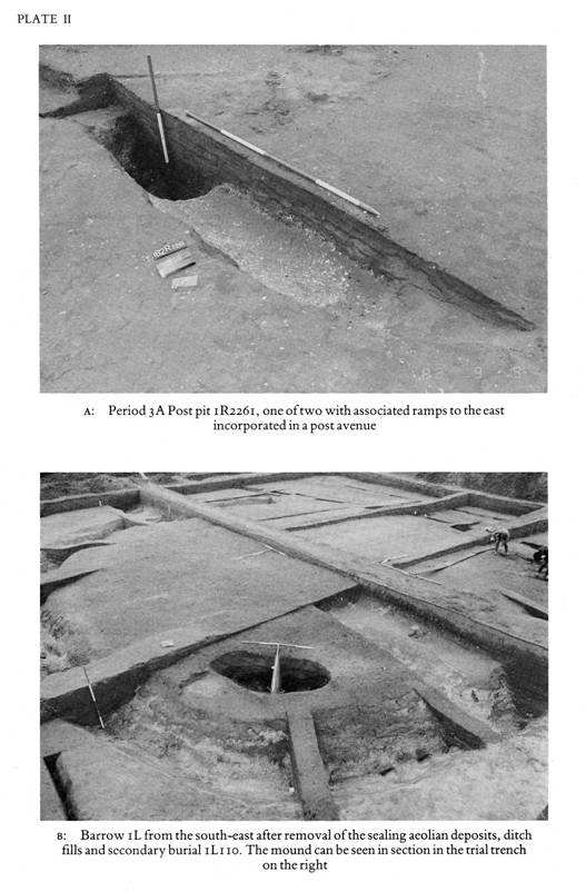
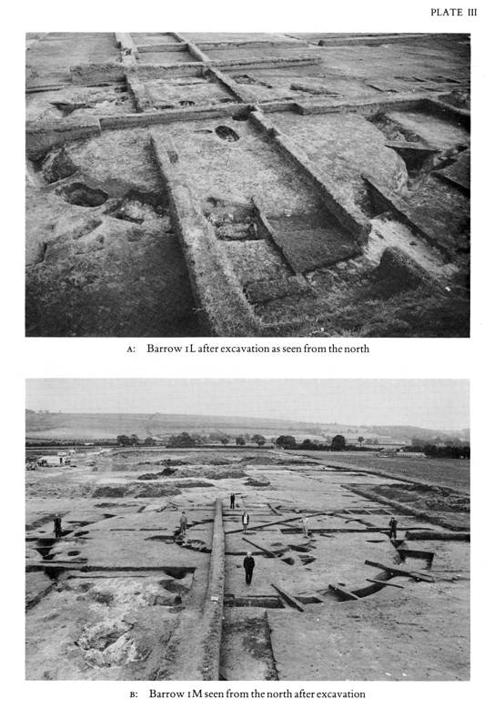
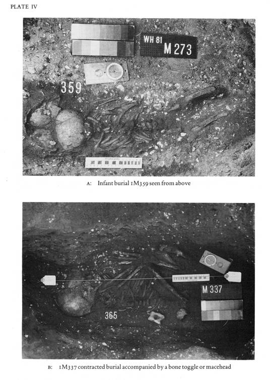
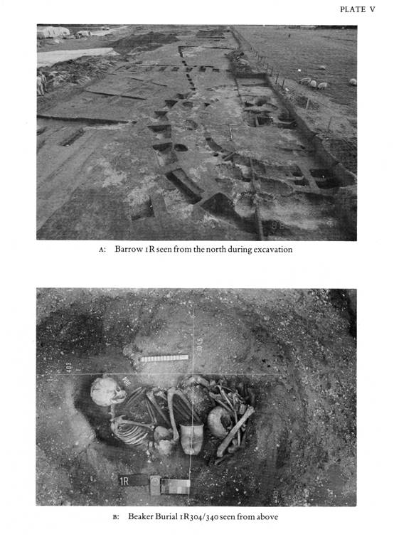
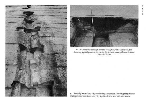
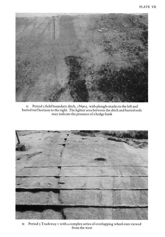
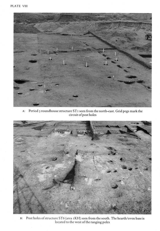
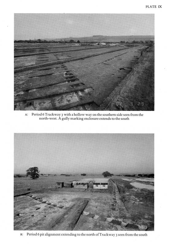
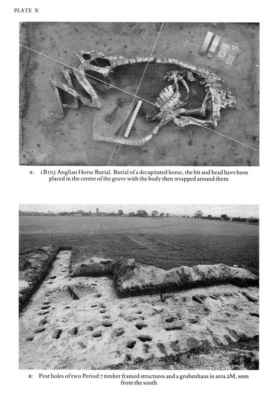
BIBLIOGRAPHY
The bibliographies for the specialist reports appear in the microfiche after the relevant sections.
Alcock, L. A. 1973 Arthur's Britain, Harmondsworth: Pelican
Barker, G. (ed.) 1981 Prehistoric Communities in Northern England: essays in economic andsocial reconstruction, Sheffield: University Press
Bowen, H. C. and Fowler, P. J. (eds) 1978 Early Land Allotment in the British Isles, Oxford: BAR
Brewster, T. C. M. 1952 Two Mediaeval Habitation Sites in the Vale of Pickering, York: Yorkshire Museum
Brewster, T. C. M. 1957 Excavations at Newham's Pit, Staxton, 1947-8, Yorkshire ArchaeolJ., 39 (1957), 193-223
Brewster, T. C. M. 1963 The Excavation of Staple Howe, E. Riding Arch. Res. Committee
Brewster, T. C. M. 1981 The Devil's Hill, Current Archaeol., 76 (1981), 140-41
Burgess, C. 1980 The Age of Stonehenge, London: Dent
Burgess, C. and Miket, R. (eds.) 1976 Settlement and Economy in the Third and Second Millennia B.C.,Oxford: BAR
Burgess, C. and Shennan,
S. (eds.)
1976
The beaker phenomenon: some suggestions. Settlement and Economy
in the Third and Second Millennia B.C. ed. Burgess,
C. and Miket, R. (1976), 309-26, Oxford: BAR
Challis, A. J. and Harding, D.W. (eds.) 1975 Later Prehistory from the Trent to the Tyne, Oxford: BAR
Clark, R. M. 1975 A calibration curve for radiocarbon dates Antiquity, 49 2Si-66
Clarke, D. 1970 The Beaker Pottery of Great Britain, Cambridge: University Press
Cowie, T. 1978 Bronze Age Food Vessel Urns, Oxford: BAR
Cunliffe, B. 1978 Iron Age Communities in Britain, (2nd edition), London: Routledge and Kegan Paul
Cunliffe, B. 1984 Danebury: an Iron Age Hillfort in Hampshire, London: Council for British Archaeology
Cunliffe, B. and Rowley T. (eds.) 1978 Lowland Iron Age Communities in Europe, Oxford: BAR
DOE 1975 Principles of Publication in Rescue Archaeology, London
Donaldson, P. 1977 The Excavation of a Multiple Round Barrow at Barnack, Cambridgeshire, 1974-76, Antiq.J., 57, 197-231
Drewett, P. 1979 New evidence for the structure and function of Middle Bronze Age round houses in Sussex, Archaeol. J., 136, 3-11
Elgee, H. W. and F. 1949 An Early Bronze Age Burial in a Boat-Shaped Wooden Coffin from North-East Yorkshire. Proc. Prehist. Soc., 15, 87-106
Evans, J. G. 1975 The Environment of Early Man in the British Isles. London
Evans, J. G., Limbrey, S. and Cheere H (eds.) 1975 The Effects of Man on the Landscape: the Highland Zone, London: Council for British Archaeology
Fleming, A
1978
The Dartmoor Reaves. Early Land Allotment in the British Isles: asurvey of
recent work, ed. Bowen, H. C. and Fowler, P.
J. 17-41, Oxford: BAR
Frere, S. S. 1978 Britannia (rev. edn.) London: Routledge and Kegan Paul
Glasbergen, W.
1954
Barrow Excavation in the Eight Beatitudcs. The Bronze Age Cemetery between
Toterfout and Halve Mijl, North Brabant,
N. The Implications. Palaeohistoria, 3, 1-204
Greenwell, W. and Rolleston, G. 1877 British Barrows, Oxford: University Press
Harding, D. W. 1974 The Iron Age in Lowland Britain. London: Routledge and Kegan Paul
Jobey, G. 1968 Excavations of Cairns at Chatton Sandyford, Northumberland, Archaeol. Ael., 46, 5-50
Lanting, J. N. and van der Waals, J. D. 1972 British Beakers as seen from the Continent, Helinium 12, 20-46
Lynch F. and Burgess, C. (eds.) 1972 Prehistoric Man in Wales and the West, Bath: Adams and Dart
Manby, T. G. 1974 Grooved Ware Sites in the North of England, Oxford: BAR
Manby, T. G. 1975 Neolithic Occupation Sites on the Yorkshire Wolds. Yorks Archael.J., 47, 23-59
Manby, T. G.
1980
Bronze Age Settlement in Eastern Yorkshire. Settlement and Societyin the
Later Bronze Age, eds. J. Barrett and R.
Bradley, Oxford: BAR
Megaw, J. V. S. and Simpson, D. D. A. 1979 Introduction to British Prehistory, Leicester: University Press
Millett, M. 1983 Excavations at Cowdery's Down, Basingstoke, Hampshire, 1978-81 Archaeol.J., 140, 151-279
Mortimer, J. R. 1905 Forty Years Researches in British and Saxon Burial Mounds in EastYorkshire, London: A. Brown and Sons
Musson, C. R. 1970 Round Houses. Current Archaeol., 2, 267-75
Pierpoint, S. J.
1981
Land, settlement and society in the Yorkshire Bronze Age. Prehistoric
Communities in Northern England. Essays in
Economic and Social Reconstruction, ed. G. Barker,
Sheffield: University Press
Powlesland, D. J. 1981 West Heslerton. Current Archaeol. 76, 142-144
Powlesland, D. J. 1986 Staple Howe in its setting (forthcoming)
Pryor, F. 1974 Excavation at Fengate, Peterborough, England: 1st Report, Toronto: Royal Ontario Mus.
Pryor,F. 1978 Excavation at Fengate, Peterborough, England: 2nd Report, Toronto: Royal Ontario Mus.
Renfrew, C. (ed.) 1974 British Prehistory: a new outline, London: Duckworth
Spratt, D. (ed.) 1982 Prehistoric and Roman Archaeology of North-East Yorkshire, Oxford: BAR
Stead, I. 1979 The Arras Culture, York: Yorkshire Philosophical Society
Thurnam, J. 1873 On Ancient British Barrows, especially those of Wiltshire and the adjoining counties. Archaeologia, 43, 285-544
Vatcher, F. and L. de 1965 East Heslerton Long Barrow, Yorkshire: Eastern Half. Antiquity, 39, 49-52.
Watson, J. 1984 Identification of organic material associated with metal objects from West Heslerton, Yorkshire, AML Report 4255
West, S. E. 1969 The Anglo-Saxon village of West Stow: an interim report of the excavations, 1965-68. Medieval Archaeol., 8, 1-20
Wilson, D. (ed) 1981 The Archaeology of Anglo-Saxon England. Cambridge: University Press
INDEX TO THE MICROFICHE
M1/01-33 The First Flint Report by Gillian Wilson
M1/34-71 The Second Flint Report by Gillian Wilson
M1/72-74 Methodology and Stripping Methods
M1/75 Period 0: The Earlier Mesolithic
M1/76-95 The First Soil Report by Richard MacPhail
M2/01-10 The Second Soil Report by Richard MacPhail
M2/11-17 Palaeostream Bed Study by S. Zylawyj
M2/18-22 The Human Bones by Jean Dawes
M2/23-49 The Late Neolithic and Early Bronze Age Pottery by T. G. Manby
M2/50 The Molluscs by M. Allen
M2/51-52 The Plant Remains by M. Allen
M2/54-70 The Later Prehistoric and Roman Pottery
M2/71 Other Small Finds: Catalogue
M3/01 Barrow L Graves
M3/02 Period 0 1R52 Stream Bed Sample Trench
M3/03-41 Site Master Plans
This paper was originally published with the aid of a grant from the Historic Buildings and Monuments commission for England.